Please register to participate in our discussions with 2 million other members - it's free and quick! Some forums can only be seen by registered members. After you create your account, you'll be able to customize options and access all our 15,000 new posts/day with fewer ads.
I'l be posting updates as best I can in here regarding Tornadoes. Since the other thread was "first twisters" I figure we're in the 2nd half of the year now.
Lets start with today..
Check out this 3D capture of a cell in Oklahoma right now. Within 30 minutes time it went from a cloud forming and billowing to a monster cell.
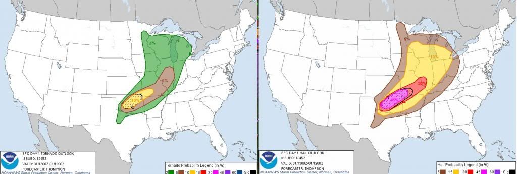
TORNADO WARNING FOR...
CENTRAL CANADIAN COUNTY IN CENTRAL OKLAHOMA...
* UNTIL 615 PM CDT
* AT 533 PM CDT...NATIONAL WEATHER SERVICE METEOROLOGISTS DETECTED A
SEVERE THUNDERSTORM CAPABLE OF PRODUCING A TORNADO. THIS DANGEROUS
STORM WAS LOCATED 7 MILES NORTHEAST OF HINTON...AND MOVING EAST AT
25 MPH.
IN ADDITION TO A TORNADO...LARGE DESTRUCTIVE HAIL UP TO TENNIS BALL
SIZE IS EXPECTED WITH THIS STORM.
* LOCATIONS IMPACTED INCLUDE...
EL RENO.
3D view of Tornado Warned Cell in OK just west of Oklahoma City right now. Lots of rotation. Heading towards Oklahoma city but might go north of there (and Moore)
Speechless. AGAIN!!! Multiple voticies within one massive storm. I cant even keep going with reports. Good luck to everyone, Here's just a couple reports. We wont know until sun comes up what the extent in. Man o Man
I appreciate your input here Cambium, I DO!! I'm streaming one of the OKC stations online, and have been flip flopping between Fox, CNN, and the Weather Channel. The width of this thing just astounds me! One of the tornadoes is coming right at Tinker Air Force Base. Another went through the I-44- I-35-I-40 interchange a half hour ago. Sadly, it is a somewhat chaotic scene. the reporters are saying that there is so much rain coming down that some of the traffic on the interstates are a parking lot. They can't see where they are going-period. wall clouds are on three sides of the tornado. On the Oklahoma weather thread, one of the posters said one of the tornadoes is angling SOUTH!
As I'm watching the tube now, it is really dark.
The storm people called it right. They said this afternoon was trouble. It is. Sadly.
Please register to post and access all features of our very popular forum. It is free and quick. Over $68,000 in prizes has already been given out to active posters on our forum. Additional giveaways are planned.
Detailed information about all U.S. cities, counties, and zip codes on our site: City-data.com.

 Please register to participate in our discussions with 2 million other members - it's free and quick! Some forums can only be seen by registered members. After you create your account, you'll be able to customize options and access all our 15,000 new posts/day with fewer ads.


")