Please register to participate in our discussions with 2 million other members - it's free and quick! Some forums can only be seen by registered members. After you create your account, you'll be able to customize options and access all our 15,000 new posts/day with fewer ads.
That's quite exceptional. I wonder how this cold spell compares with previous ones in years just gone as this one is causing all sorts of problems not experienced in 2010
The Elfstedentocht (Eleven Cities Tour) a Dutch 200km speed skating race has been rated a 80% chance of going ahead. A unique event in that it can only be held when temperatures allow the ice to develop to a sufficient thickness along the entire route. Its only been held 15 times since 1909 the last time being in 1997; they're estimating up to 2 million spectators if it's given the go-ahead. Fingers crossed!
The Elfstedentocht (Eleven Cities Tour) a Dutch 200km speed skating race has been rated a 80% chance of going ahead. A unique event in that it can only be held when temperatures allow the ice to develop to a sufficient thickness along the entire route. Its only been held 15 times since 1909 the last time being in 1997; they're estimating up to 2 million spectators if it's given the go-ahead. Fingers crossed!
That's quite exceptional. I wonder how this cold spell compares with previous ones in years just gone as this one is causing all sorts of problems not experienced in 2010
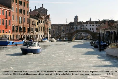
Overall to me (a non-European observer) it looks more severe than 2010, but not so much in Western Europe as in Eastern Europe. I believe it's far colder in Eastern Europe and Russia this time than in 2010, and also colder in the Mediterranean. I don't recall Venetian canals freezing in 2010 or multiple North African snow events in a short period. It looks like that's due mostly to a very cold, very deep cut-off part of the polar vortex that's lingering over Eastern Europe and if memory serves me correctly it looks like it's going to be parked there for a while.
I don't think it's significantly colder than 2010 in Eastern Europe. It's of comparable intensity it seems, though colder lows were reached this year in the Baltic countries.
As an example, Minsk in Belarus in January 2010:
Average: -9/-16°C (4/15°F)
Coldest high: -19°C (-2°F)
Coldest low: -28°C (-18°F) History : Weather Underground
I chose Minsk cause it's roughly the center of what I'd call "Eastern Europe", maybe the result is different for other cities. Apparently Minsk had a -21°C/-32°C day this year so a bit colder for extremes, but let's wait how it evolves in the longer term.
Overall to me (a non-European observer) it looks more severe than 2010, but not so much in Western Europe as in Eastern Europe. I believe it's far colder in Eastern Europe and Russia this time than in 2010, and also colder in the Mediterranean. I don't recall Venetian canals freezing in 2010 or multiple North African snow events in a short period. It looks like that's due mostly to a very cold, very deep cut-off part of the polar vortex that's lingering over Eastern Europe and if memory serves me correctly it looks like it's going to be parked there for a while.
I don't know about eastern Europe but in Holland the Elfstedentocht was apparently going to happen relatively recently (January 2010?) but had to be cancelled at the last minute - presumably if it goes ahead this time then it's been a more severe cold snap. Also in Scotland there's a similar tradition called the Grand Match, a curling match on a loch which needs seven inches of ice thickness to take place - this was going to go ahead for the first time in decades in January 2010 but they had to cancel because apparently road conditions were bad enough it wouldn't have been safe enough to get ambulances out in case people fell through the ice. I don't think it's been cold enough in Scotland this winter for the lochs to freeze much if at all though.
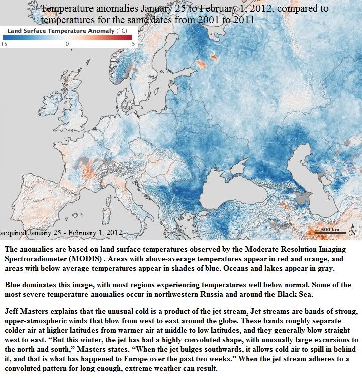
This map above shows temperature anomalies for Europe and western Russia from January 25 to February 1, 2012, compared to temperatures for the same dates from 2001 to 2011. The anomalies are based on land surface temperatures observed by the Moderate Resolution Imaging Spectroradiometer (MODIS) on NASA’s Terra satellite. Areas with above-average temperatures appear in red and orange, and areas with below-average temperatures appear in shades of blue. Oceans and lakes appear in gray.
Blue dominates this image, with most regions experiencing temperatures well below normal. Some of the most severe temperature anomalies occur in northwestern Russia and around the Black Sea.
Masters explains that the unusual cold is a product of the jet stream. Jet streams are bands of strong, upper-atmospheric winds that blow from west to east around the globe. These bands roughly separate colder air at higher latitudes from warmer air at middle to low latitudes, and they generally blow straight west to east. “But this winter, the jet has had a highly convoluted shape, with unusually large excursions to the north and south,” Masters states. “When the jet bulges southwards, it allows cold air to spill in behind it, and that is what has happened to Europe over the past two weeks.” When the jet stream adheres to a convoluted pattern for long enough, extreme weather can result.
The Arctic Oscillation (AO) Index provides an indication of whether the jet stream has formed an unusual bulge. When the AO is strongly negative, jet stream winds are comparatively weak, meaning it has drooped southward over Europe, dragging frigid air with it. A negative AO also often means unusual cold and snow over North America, but due to other factors, much of the United States has experienced below average snowfall.
^^ Interesting map. I seem to remember around the 10th-12th last February the monthly CET (national average temperature) was around 7 or 7.5C, similar to the all-time record high for the month (a record which has somehow stood since 1779 despite recent efforts). This year the same average is below freezing, and though I'm not expecting it to end that low, we have only had eight sub-zero Februarys in over 350 years - quite the contrast!
Close to an ice day today at 0.1C/32.1F as the maximum.. nice to see some icicles too which I have not seen since December 2010 as far as I can remember
Please register to post and access all features of our very popular forum. It is free and quick. Over $68,000 in prizes has already been given out to active posters on our forum. Additional giveaways are planned.
Detailed information about all U.S. cities, counties, and zip codes on our site: City-data.com.

 Please register to participate in our discussions with 2 million other members - it's free and quick! Some forums can only be seen by registered members. After you create your account, you'll be able to customize options and access all our 15,000 new posts/day with fewer ads.


 .
.