Please register to participate in our discussions with 2 million other members - it's free and quick! Some forums can only be seen by registered members. After you create your account, you'll be able to customize options and access all our 15,000 new posts/day with fewer ads.
Britain's cloudiest town and one of the cloudiest in the world is currently one of the hottest places in the country at 27C/81F.. in fact Scotland and North West England are the hottest places in the country - these places would struggle to reach 80F in summer but in May!?.. crazy..
Weird is more like it. Weren't these places the hottest in the U.K. last March, too?
Here, it's 73F with completely clear and deep blue skies.. true blue dome day, much nicer than the milky coloured sky of yesterday.
That's one of the biggest reasons why I abhor humidity. The clearer, cleaner skies is a big plus. When it's clear and sunny I like to have a lot of visibility.
Quote:
Originally Posted by Superduy
High a of 7c today.. what a JOKE!
I consider it a nice cool shot. Then again, I prefer much cooler summers than you do so I'll let you be .
Quote:
Originally Posted by Cambium
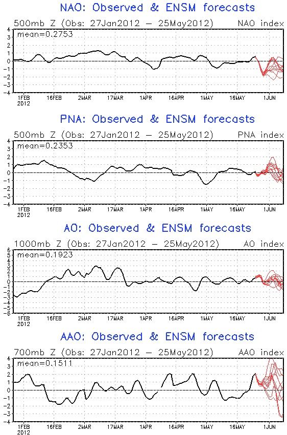
All ensembles models agree on the NAO tanking the most since last year..
Yep. "Big time" cooling is coming to some parts of the States. The NAO will induce more persistent troughing in early June .
Below is a snapshot of one of the chillier model runs (it's well-supported, so pay attention):
For June 1 there will be a strong cold front (with possibly some severe thunderstorms) moving through, and the backside of a low-pressure system is pegged to feature breezy and extremely cool conditions for some areas. A huge region stretching as far south as western Tennessee might not make it out of the 50's on June 1 . There may be another big area that won't make it out of the 40's. A spot near the Quad Cities is progged to have a high of 45F according to this run. The night-time temperatures are also very cool for this time of year in this region (<50F), although it doesn't look like record lows are in jeopardy, though record low maximums may be shattered in spots.
Sub-60F highs stretching that far south seemed very unusual to me, so I poured over the older COOP stations this morning. From the 1890's to the present, those parts of western Tennessee have never had a sub-60F high on June 1 (or May 31 or June 2 for that matter).
If this occurs, and there is a good chance it will, then it will be historically unprecedented for this late in the season. Many Midwesterners will be getting a taste of what life is like in my dream climate if this verifies .
That's one of the biggest reasons why I abhor humidity. The clearer, cleaner skies is a big plus. When it's clear and sunny I like to have a lot of visibility.
I consider it a nice cool shot. Then again, I prefer much cooler summers than you do so I'll let you be .
Yep. "Big time" cooling is coming to some parts of the States. The NAO will induce more persistent troughing in early June .
Below is a snapshot of one of the chillier model runs (it's well-supported, so pay attention):
For June 1 there will be a strong cold front (with possibly some severe thunderstorms) moving through, and the backside of a low-pressure system is pegged to feature breezy and extremely cool conditions for some areas. A huge region stretching as far south as western Tennessee might not make it out of the 50's on June 1 . There may be another big area that won't make it out of the 40's. A spot near the Quad Cities is progged to have a high of 45F according to this run. The night-time temperatures are also very cool for this time of year in this region (<50F), although it doesn't look like record lows are in jeopardy, though record low maximums may be shattered in spots.
Sub-60F highs stretching that far south seemed very unusual to me, so I poured over the older COOP stations this morning. From the 1890's to the present, those parts of western Tennessee have never had a sub-60F high on June 1 (or May 31 or June 2 for that matter).
If this occurs, and there is a good chance it will, then it will be historically unprecedented for this late in the season. Many Midwesterners will be getting a taste of what life is like in my dream climate if this verifies .
Any hope of that goodness making its way down here to Georgia?? Please, pretty please???
Let's hope this cold front brings some HUGE thunderstorms our way too - this hazy sun, blue sky, no rain crap is getting old far too soon...
I'm amused at the links in your favorites bar. Doesn't put us any closer to figuring out where you live, but we can figure what climates you like.
*evil laugh* Everything in my computer system is carefully designed to booby-trap anyone trying to figure out where I live . Seriously, you can figure out what climates I like to monitor, though there is not necessarily a correlation to what I like (but usually there is, and in this case I follow the usual pattern). As an example, do you really think I like Santa Monica, California's climate?
Quote:
Originally Posted by NorthStarDelight
Any hope of that goodness making its way down here to Georgia?? Please, pretty please???
Although Georgia will be pretty off from the main axis of chill, I've looked at that same model run and, just as I expected, the frontal passage makes it through to your area a bit later. That particular model run has the front clearing your area sometime during the night of June 1-2, with a low in the upper 40's in Atlanta. June 2 is progged to have a high of 75F in your location, followed by a low of around 50F and a high around 70F on the 3rd. 80's return soon enough, though, but this occurs region-wide.
So, if this system verifies, you won't get the brunt of the chill but North Georgia should get some cooling. Anything below 50F is abnormal this time of year in Atlanta, and your June 2 record low of 49F would be in jeopardy.
As for thunderstorms, it looks like there are some thunderstorms ahead of the front, but don't bet on my assessing anything more than that, because I am neither knowledgeable about how to interpret big thunderstorm potential on model runs nor did I even take more than a glance at the thunderstorm potential.
Looking back, the "axis of chill" has a nice sound to it .
Spring is the driest and sunniest time of the year here. May has been slightly warmer than average but still nicely cool. The Sun now sets after 10 PM and nautical twilight lasts throughout the night so there's plenty of light already. Personally I'm not a big fan of the California style blue skies every day, can't wait for summer rains to arrive.
Although Georgia will be pretty off from the main axis of chill, I've looked at that same model run and, just as I expected, the frontal passage makes it through to your area a bit later. That particular model run has the front clearing your area sometime during the night of June 1-2, with a low in the upper 40's in Atlanta. June 2 is progged to have a high of 75F in your location, followed by a low of around 50F and a high around 70F on the 3rd. 80's return soon enough, though, but this occurs region-wide.
So, if this system verifies, you won't get the brunt of the chill but North Georgia should get some cooling. Anything below 50F is abnormal this time of year in Atlanta, and your June 2 record low of 49F would be in jeopardy.
As for thunderstorms, it looks like there are some thunderstorms ahead of the front, but don't bet on my assessing anything more than that, because I am neither knowledgeable about how to interpret big thunderstorm potential on model runs nor did I even take more than a glance at the thunderstorm potential.
Looking back, the "axis of chill" has a nice sound to it .
Man, if this verifies, I'll be in heaven. That'd be *awesome* for down here for early June, almost miraculous, even.
Oh yeah, the "axis of chill" does have a nice ring to it, doesn't it?
Please register to post and access all features of our very popular forum. It is free and quick. Over $68,000 in prizes has already been given out to active posters on our forum. Additional giveaways are planned.
Detailed information about all U.S. cities, counties, and zip codes on our site: City-data.com.

 Please register to participate in our discussions with 2 million other members - it's free and quick! Some forums can only be seen by registered members. After you create your account, you'll be able to customize options and access all our 15,000 new posts/day with fewer ads.


 .
. .
.
 .
. Please, pretty please???

 . Seriously, you can figure out what climates I like to monitor, though there is not necessarily a correlation to what I like (but usually there is, and in this case I follow the usual pattern). As an example, do you really think I like Santa Monica, California's climate?
