Please register to participate in our discussions with 2 million other members - it's free and quick! Some forums can only be seen by registered members. After you create your account, you'll be able to customize options and access all our 15,000 new posts/day with fewer ads.
The effects of the "severe" drought came quickly, the grass was pretty lush a few weeks ago (despite the drought) but turned into straw almost instantly in many spots.
Long Island, NY:
The grass all over the Tri-State area is not in the best shape. However, the rain showers yesterday did help. My lawn is much greener than it was a week ago.
It not so surprising. Look at the data for NWS Central Park.
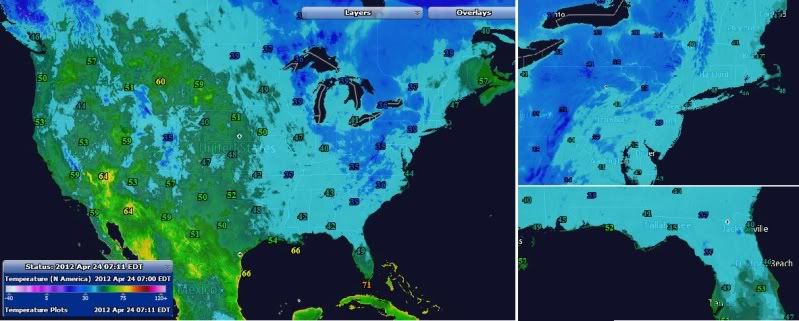
Infrared Loop From NOAA. Pretty cool. Watch the front slide East, Storm develop in Gulf, front stalls, storm moves up the coast and merges with the northern jet behind the front.
Link to their Story: http://www.nnvl.noaa.gov/MediaDetail2.php?MediaID=1051&MediaTypeID=3&Resour ceID=104603 A Nor’easter storm is bringing heavy rains and snow to many parts of the Northeast U.S. The system developed as a large front moved across the U.S. on Friday, combining with a smaller convective system off the coast of Florida. As this system moved north, it intensified and drew in cold air from the Great Lakes region. Lake–effect snows of up to 12-18 inches have fallen in the higher elevations of West Virginia through New York. Winter storm warnings have been issued by the National Weather Service for these areas. This time-lapse animation uses infrared imagery from the NOAA GOES-13 satellite to track the storms’ movement from April 20-23, 2012. Nor’easters are most commonly associated with winter storms, but can occur at any time of the year.
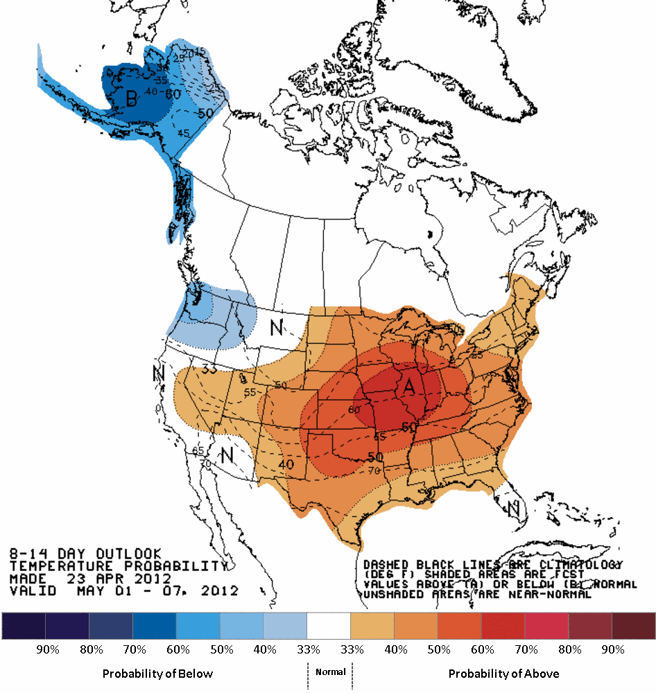
I don't known if anyone saw the update for May issued yesterday for the USA and southern Canada. If they are correct - then May 2012 could pick up where April 2012 left off in the central and eastern USA. MMT have been from 2 to 4 F above normal at most NWS stations in the USA, although the center of the warmer than normal conditions seems to have been in the I-95 states. NWS stations from Washington Dc to parts of NJ have been as much as 5 to 6 F above normal. This is what they are thinking for May 2012:
Looks like May will be warmer than normal for mos of us outside the PNW.
This current storm is really something, not to mention a rare event. The people on the internet are comparing this one to the October 2011 blizzard, but to me it looks a lot more similar to the late November 2011 snowstorm that stretched from Mississippi to Michigan; the structure is similar, not to mention the big dry slot and overall ragged appearance. The Weather Channel has a webpage (http://www.weather.com/outlook/weather-news/news/articles/snowpril-slideshow_2012-04-23 - broken link) with pictures for what they're dubbing "Snowpril" (really an awful moniker). There's also an article of totals from the storm, which are pretty heavy for this time of year, and also it seems that Jim Cantore was visited by Santa Claus (no doubt both of them were attracted by the snow )
There's also something new that has showed up on The Weather Channel. On April 30, frosty weather is forecast to occur in places where temperatures below 40F that late in the year are unusual. Lexington, Kentucky is forecast to be 38F on the 30th and Nashville is forecast to be 39F. That's cold enough for some frost on the rooftops if it's a clear, calm night.
If this occurs then it would continue the current cooling trend relative to normal that has taken hold since midmonth or so. The cool airmasses continue to have much more of a punch than they did in most of March and the first half of April, and as Spring/early Summer progresses it doesn't seem to be getting much warmer in the Eastern interior, at least not until past 10 days out. This is also consistent with what the JMA and a few other forecasts predicted would happen, and that involves an autumn and winter with close to record cold temperatures overall, with conditions averaging colder than normal across the 48 contiguous States.
We in the Pacific Northwest got a temporary reprieve from the epic cold and wet conditions we have had to endure this spring season. Last Friday (4/20) was the start of a four day stretch of weather that would have compared favorably to late June; sunny, warm, comparatively windless and not too muggy. High temperature records fell like ninepins all over our region, the Northern Rockies and southern Alberta. It has been a grand sabbatical!
All that comes to an end today (4/24) when February returns with a vengeance. Periods of rain are forcast on a daily basis clear to the end of the first week of May and temperatures return to their 5 or so degrees below seasonal norms.
It was nice while it lasted.....
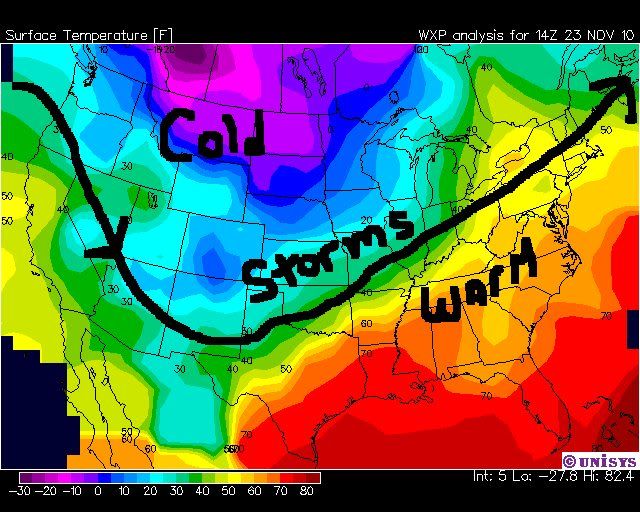
No doubt...not a good patten for you guys. The pattern has been stuck in this configuration since last November (more or less):
.
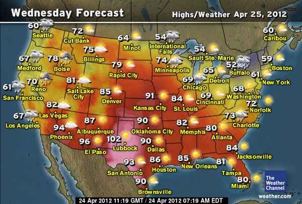
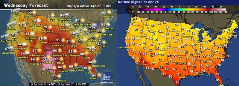
Now that trough has retreated all the way up to the high plains... the heat is building in the eastern half of the desert Southwest. As we really get going into May, June, July...etc and the desert heat starts building, the central of the USA could get very hot. Already the 90's and low 100's are showing up in West Texas. Here is Wed forecast highs. Texas will see upper 90's to low 100's, hotter than most of Florida or AZ:
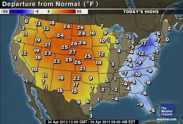
And Wednesdays forecast next to the normals shows even Florida below normal and most of East coast thanks to the trough. I guess the spin stops here. lol
I think the pattern becomes the most obvious when one reads a from press realease NOAA/NWS:
State of the Climate
National Overview
March 2012
National Oceanic and Atmospheric Administration
National Climatic Data Center
•Year-to-Date (January-March).
•The first three months of 2012 were also record warm for the contiguous United States with an average temperature of 42.0 degrees, which is 6.0 degrees above the long-term average.
•For the January-March period, 25 states east of the Rockies had three-month average temperatures which were the warmest on record, and an additional 16 states had temperatures for the first-quarter of 2012 ranking among their ten warmest. Numerous cities had a record warm January-March, including Chicago, Boston, and Washington, D.C. No state in the Lower-48 had 3-month temperatures below average.
•The nationally-averaged precipitation total for January-March was 0.29 inch below the long-term average. States across the Pacific Northwest and Southern Plains were wetter than average, while the Intermountain West, parts of the Ohio Valley, and the entire Eastern Seaboard were drier than average.
• Warm maximum and minimum temperatures dominated across most of the Northeast, Upper Midwest, Ohio Valley, Northern Rockies and Plains, Southeast and South regions. Half of the Southeast region experienced extremes caused by drought and a record 27 percent of the South region experienced extremes caused by heavy 1-day precipitation events
I think a few days in a 90 or 120 pattern mean little. If NOAA is attempting to spin anything...then I’m with them. If this is what temps look like a few degrees below normal...lol
Please register to post and access all features of our very popular forum. It is free and quick. Over $68,000 in prizes has already been given out to active posters on our forum. Additional giveaways are planned.
Detailed information about all U.S. cities, counties, and zip codes on our site: City-data.com.

 Please register to participate in our discussions with 2 million other members - it's free and quick! Some forums can only be seen by registered members. After you create your account, you'll be able to customize options and access all our 15,000 new posts/day with fewer ads.


 )
)