Please register to participate in our discussions with 2 million other members - it's free and quick! Some forums can only be seen by registered members. After you create your account, you'll be able to customize options and access all our 15,000 new posts/day with fewer ads.
Yep, snow is still continuing in parts of the West on the same day that people have gathered for the Solstice in Stonehenge.
Quote:
…WINTER WEATHER ADVISORY IN EFFECT FROM MIDNIGHT TONIGHT TO NOON TUESDAY FOR ELEVATIONS ABOVE 6500 FEET…
RAIN IS EXPECTED TO CHANGE OVER TO SNOW LATE THIS EVENING AND WILL LAST INTO TUESDAY MORNING. SLUSHY SNOW ACCUMULATIONS AND POOR VISIBILITIES ARE POSSIBLE AT LOGAN PASS AND LIKELY IN THE HIGHER TERRAIN OF GLACIER NATIONAL PARK. PERSONS AT LOGAN PASS AND THOSE VENTURING INTO THE HIGHER BACK COUNTRY SHOULD BE PREPARED FOR WINTER CONDITIONS.
SNOW ACCUMULATIONS: 1 TO 3 INCHES POSSIBLE AT LOGAN PASS WITH 4 TO 6 INCHES LIKELY ABOVE 7500 FEET.
What I dont get is.... snow has been continuing to fall above 6000 feet for months now here and there. That altitude is like the high peaks of the NorthEast yet we NEVER see this much snow in April/May/June up there. Whats the difference between 6000 feet in the West and 6000' in the East?
What I dont get is.... snow has been continuing to fall above 6000 feet for months now here and there. That altitude is like the high peaks of the NorthEast yet we NEVER see this much snow in April/May/June up there. Whats the difference between 6000 feet in the West and 6000' in the East?
Since if anything, our summers (in Northern New England) are cooler than the interior west, it's probably because our summers are more variable. The PNW spring and summer is cooler than here at sea level, so lower elevations are prone to snow.
I assume you mean greater snowfall not snow cover? We also only have one peak that gets above 6000 feet, and it does get regular snow in the spring, but not consistent snow cover past April.
What I dont get is.... snow has been continuing to fall above 6000 feet for months now here and there. That altitude is like the high peaks of the NorthEast yet we NEVER see this much snow in April/May/June up there. Whats the difference between 6000 feet in the West and 6000' in the East?
Keep in mind that Montana, Wyoming, and Idaho is at a much higher lattitude than most of the peaks in the Applachians as well. Plus I am pretty sure the higher peaks in the area that have snow cover year around probably has the net effect of dropping the temperature.
As far as the mountain ranges in the PNW goes, they are pretty much at the same lattitude as the maritime provinces in Eastern Canada (Prince Edward Island, Nova Scotia, and New Brunswick). Plus most of the weather comes out of the Gulf of Alaska, which is pretty chilly even in the summer.
...WIDESPREAD SNOWMELT AROUND SOUTHCENTRAL ALASKA RESULTING IN
ELEVATED WATER LEVELS ON ALL AREA RIVERS...
REASON FOR STATEMENT: WARM TEMPERATURES THIS WEEK HAVE CAUSED SOUTHCENTRAL RIVERS AND
STREAMS TO BECOME SWOLLEN WITH SNOWMELT. A SIGNIFICANT SNOWPACK
REMAINS IN THE UPPER ELEVATIONS DUE TO THE COOLER THAN NORMAL SPRING. WARM TEMPERATURES AND HIGH FREEZING LEVELS WILL PERSIST THROUGH
SATURDAY BEFORE A PATTERN CHANGE ON SUNDAY BRINGS A RETURN OF COOLER
ONSHORE FLOW. RIVER LEVELS WILL CONTINUE TO RISE AND LIKELY CREST
THIS WEEKEND. ISOLATED THUNDERSTORMS THURSDAY MAY CAUSE FURTHER
RISES.
EXPECTED IMPACTS:
AT THIS TIME...FLOODING IS NOT EXPECTED ALTHOUGH SOME RIVERS AND
STREAMS MAY APPROACH BANKFULL OR EXPERIENCE VERY MINOR LOCAL FLOODING
IN LOW LYING AREAS. WATER LEVELS WILL BE HIGH ENOUGH TO CAUSE LOCAL
BANK EROSION ESPECIALLY ALONG THE MATANUSKA RIVER. RECREATIONAL
ENTHUSIASTS SHOULD EXERT CAUTION AND BE ALERT FOR HIGH WATER.
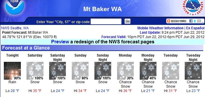
Looking at data for Mt. Baker. Every location running well above average for the entire year, even as we crawl into Summer time. Every Max snow pack depth measured in the last 50 years..with 60% of the snowpacks breaking Max records since 1999
The Avg snow pack for the area is 141″. The current snowpack as of today is 211″
Last year at this time, the snowpack was 241″
Through 2011 the Max record for snow pack at Mt. Baker was 270″ in 1999, the lowest snow pack recorded was 20″ in 1934
Looking at data for Mt. Baker. Every location running well above average for the entire year, even as we crawl into Summer time. Every Max snow pack depth measured in the last 50 years..with 60% of the snowpacks breaking Max records since 1999
The Avg snow pack for the area is 141″. The current snowpack as of today is 211″
Last year at this time, the snowpack was 241″
Good to hear this year is nearly as bad as last. It would have been frustrated to hear the opposite.
Please register to post and access all features of our very popular forum. It is free and quick. Over $68,000 in prizes has already been given out to active posters on our forum. Additional giveaways are planned.
Detailed information about all U.S. cities, counties, and zip codes on our site: City-data.com.

 Please register to participate in our discussions with 2 million other members - it's free and quick! Some forums can only be seen by registered members. After you create your account, you'll be able to customize options and access all our 15,000 new posts/day with fewer ads.


 Only 1 month of no snow. lol