Please register to participate in our discussions with 2 million other members - it's free and quick! Some forums can only be seen by registered members. After you create your account, you'll be able to customize options and access all our 15,000 new posts/day with fewer ads.
Closer Look at the Winter Season, Next Week's Storm and Factors for the Winter Forecast
Thanks Joe for the input on the east-based blocking. The timing of the ridging in the West and positioning of the blocking will probably make it difficult for this storm to skip to the East Coast. It looks more like a strong, single wave that moves up through the west side of the Appalachians with an upper low trailing. It's under this upper low that we can see some snow in the Appalachians. Farther north, in upstate New York, it may be cold enough for mostly snow in some areas.
Like I talked about yesterday, the cold will last two to three days, not a week. It will not hold and I still do not see that happening for a while.
Snowfall Map for 2012-2013
The map above is our snowfall map. Now we have had above-normal snow depicted all the way down into the southern Appalachians and interior Gulf states. The normal amount of snow in a season is low across this region. A couple of storms during the year can easily give normal. The cooling of the water temperatures off the Southeast coast could make some impact on how much snow falls this far south. The rapid intensification of storms could be farther up the coast if you look strictly at the water temperature anomalies. They are above normal farther north, but it is mostly the upper pattern that determines the development which is hard to get specific this far out. So, I am not going to change anything in this area. However, the confidence has weakened a bit based on the water temperature anomalies.
Water temperature anomalies
Normal snowfall
What is interesting about these two maps below is the change in snowfall this year compared to last expected for the southern Appalachians and Northeast. We get that ridge to build near the West coast, then we will get the northern jet diving to meeting up with the southern branch result in the change map just below.
Snowfall change
As far as temperatures, the Upper Midwest and the Southeast will see the biggest change from last year. Remember these areas were 6-9 degrees above normal last year.
Temperature change this year compared to last year...
However, looking at the big picture, the southern Appalachians and interior Gulf Coast will probably have the biggest change, with the Midwest and mid-Atlantic in a tie for second.
Biggest keys:
1.More blocking which we feel will be the case. However, will there be more west-based blocking or east-based blocking? West-based is more favorable for cold and more snow east.
2.Polar and sub tropical jet active and coming together at times for the east and staying away from the central Rockies and interior Northwest for most of the winter.
3. Snowpack much greater this year across Canada compared to last year. Air masses will be colder as they arrive in the Plains and Midwest this year compared to last year.
4.Positive height anomaly position near western Alaska. Does this retrograde to northeast Asia, allowing upper trough to remain south of Alaska and a positive PNA to hold with more ridging in the west and a mean trough in the East?
We seem to be having problems with videos making it to the blogs right now. Once we solve that issue, I will enter that into the blog. I apologize, because my video today discusses the storm.
That's some mighty cold air over Colorado. I thought it was never ending torch there?
Just kidding. And of course that map is currently in fantasy land.
Yeah. If that happens I promise I will be baptized in what is left of our dried up lake.
EDIT: Oh, it's past midnight out here in Colorado and the temperature is a balmy 60°. That's in Northern Colorado, just 75 miles from the Wyoming border and at 5,000 ft. in elevation. Amazing.
Last edited by Cosmicstargoat; 11-22-2012 at 12:36 AM..
December 1st is not too far... Winter is just around the corner.
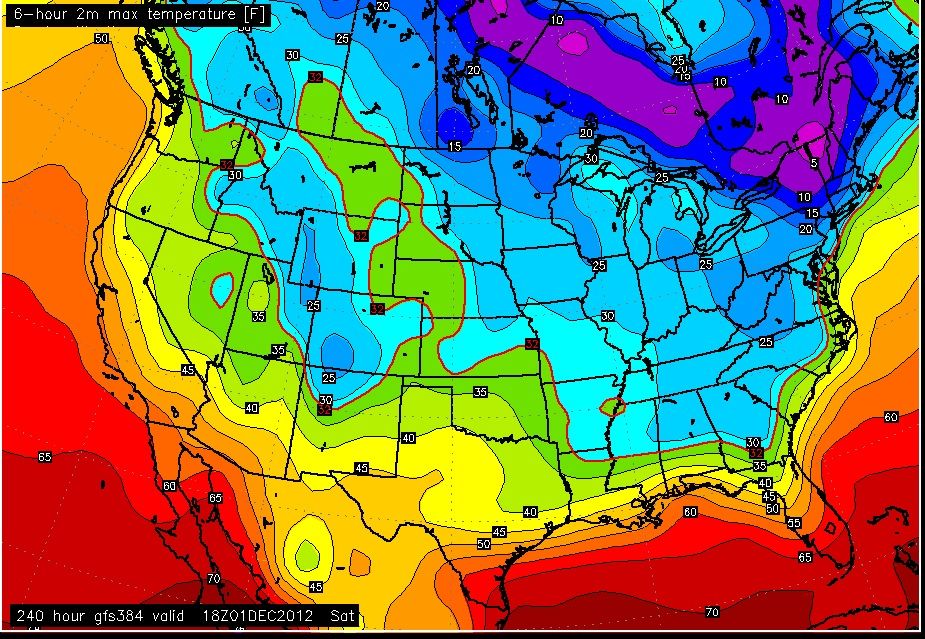
I just saw a "crazy" run of the GFS just now....
Here's what it shows.
Temps December 1st.
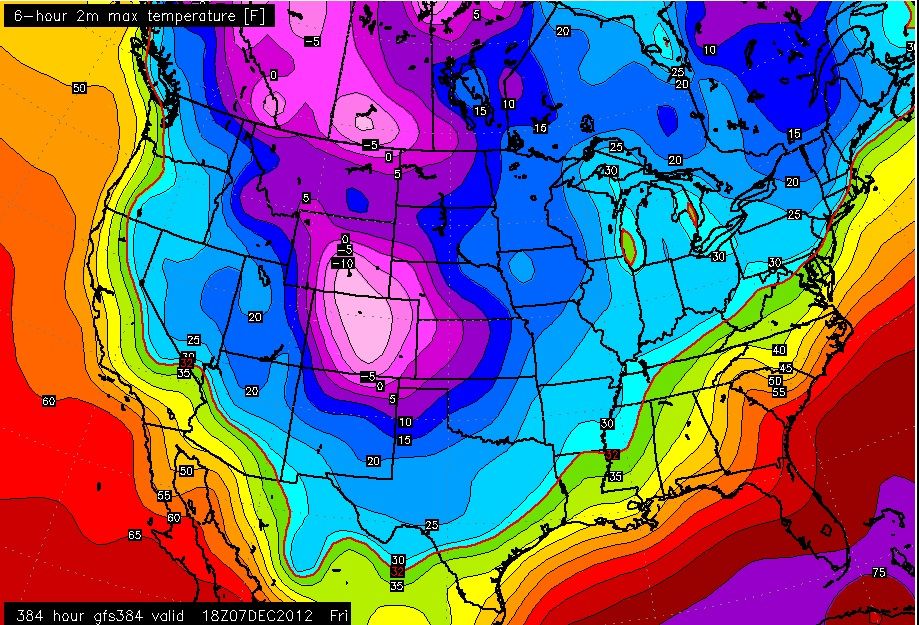
Sit down for this one... Temps for Beginning of December on the 7th.
All the long range forecasts I have seen have already quietly canceled the cold and snow that they were touting over the Rockies just a few days ago. I don't know why places like Accuweather bother with their long term, daily forecasts as there is 100% chance that they will change them as the specific date approaches. It seems they always hype cold and snow, only to change the forecast to the warmer as the day of reckoning comes.
I don't know why places like Accuweather bother with their long term, daily forecasts as there is 100% chance that they will change them as the specific date approaches. It seems they always hype cold and snow, only to change the forecast to the warmer as the day of reckoning comes.
Their 15 day forecasts, like the 18-day GFS model, can provide useful hints and help in recognizing patterns, but the 25 day forecast they have now is ridiculous. It doesn't seem that anything beyond 10 days is intended to be used as a specific, bona fide forecast; it's more like a vague guess. Still, seeing all those boxes on the calendar filled up with forecasts can be amusing. As for the hype, the long range can and has hyped warmth as much as cold, at least at my location. The norm in below-normal months is for the long range forecast to gradually slope back to normal, which naturally almost never happens. It either stays below normal or pops to a warmer state - rarely does it gradually slope back. The opposite happens with above-normal months, showing a gradual slope down (except in summer, when it shows a neverending heat wave in the long range that never materializes). I attribute all this to the "climo bias" of many forecasts.
Quote:
Originally Posted by ilovemycomputer90
That's some mighty cold air over Colorado. I thought it was never ending torch there?
Just kidding. And of course that map is currently in fantasy land.
Since it seems that CSG's main purpose here is to rave about the neverending blowtorch, I found that map very funny. Almost like Mother Nature said, "Hmm...someone here is complaining about a blowtorch in Colorado. I'll tease them with a cold wave: a Colorado special". You could call it "Cold Miser's Revenge", if you were in the holiday spirit.
Since it seems that CSG's main purpose here is to rave about the neverending blowtorch, I found that map very funny. Almost like Mother Nature said, "Hmm...someone here is complaining about a blowtorch in Colorado. I'll tease them with a cold wave: a Colorado special". You could call it "Cold Miser's Revenge", if you were in the holiday spirit.
I challenge you to show my characterization of what is going on to be anything less than spot on. I recently posted a message that showed in the last 35 months in Colorado. What is has been going on there is certainly reflected in the adjacent region, some states worse, some better:
RECORD COLDEST = 0
MUCH BELOW NORMAL=0
BELOW NORMAL =5
NORMAL=8
ABOVE NORMAL=8
MUCH ABOVE=11
RECORD WARM=3
Assigning a weight of -3,-2,-1,0,+1,+2,+3 respectively for these designations, you get a +39 and a -10 for an amazing +29 when 0.0 is baseline Normal temperatures. This does not reflect a much colder or much snowier time, it reflects a catastrophic heat wave. The piddly puddles of slight cold in the east hardly offset what has been going on in the large, continental masses of the U.S. Mother Nature does not care about our maps, our model runs or this message forum. People hype, exaggerate, lie, twist data, etc., but evidence does not lie. It's getting warmer, and has been for some time now.
Even though it will be November for this storm, I'll post here since it will have a winter feel to it.
All models are trending south with it.
It started as a system going towards the great lakes. They all flip flopped between Lake Cutter and coast and even in between. Now all models are trending towards the coast which means colder air in place and snowier.. Its not a big system at all but its still early so lets see what happens.
December 1st is not too far... Winter is just around the corner.
I just saw a "crazy" run of the GFS just now....
Here's what it shows.
Temps December 1st.
Sit down for this one... Temps for Beginning of December on the 7th. [Showing maximum day temps of -10° in Colorado.]
I'm looking at temperatures to run about 13-15° ABOVE NORMAL during that period. Where did you get that map, out of a Marvel Comic Book?
Please register to post and access all features of our very popular forum. It is free and quick. Over $68,000 in prizes has already been given out to active posters on our forum. Additional giveaways are planned.
Detailed information about all U.S. cities, counties, and zip codes on our site: City-data.com.

 Please register to participate in our discussions with 2 million other members - it's free and quick! Some forums can only be seen by registered members. After you create your account, you'll be able to customize options and access all our 15,000 new posts/day with fewer ads.