Welcome to City-Data.com Forum!
U.S. CitiesCity-Data Forum Index
Go Back   City-Data Forum > General Forums > Weather
 [Register]
Please register to participate in our discussions with 2 million other members - it's free and quick! Some forums can only be seen by registered members. After you create your account, you'll be able to customize options and access all our 15,000 new posts/day with fewer ads.
View detailed profile (Advanced) or search
site with Google Custom Search

Search Forums  (Advanced)
 
Old 07-11-2013, 09:05 AM
 
29,506 posts, read 19,606,320 times
Reputation: 4533

Advertisements

Quote:
Originally Posted by nei View Post
Warmest month on record for Amherst, MA is 75.9°F, so far we're running above that (79°F at the Chicopee station, haven't checked Amherst).
First 10 days of July 2012 we had a Mean temperature of 85.2F/29.6C. This year, 73.7F/23.2C. Luckily we will see an extended warm period here.
Reply With Quote Quick reply to this message

 
Old 07-11-2013, 05:22 PM
nei nei won $500 in our forum's Most Engaging Poster Contest - Thirteenth Edition (Jan-Feb 2015). 

Over $104,000 in prizes has already been given out to active posters on our forum and additional contests are planned
 
Location: Western Massachusetts
45,983 posts, read 53,454,351 times
Reputation: 15184
dew point down to 64°F. Feels more like normal summer.
Reply With Quote Quick reply to this message
 
Old 07-11-2013, 05:49 PM
 
Location: North West Northern Ireland.
20,633 posts, read 23,869,262 times
Reputation: 3107
Hot weather is causing sea temps to skyrocket. Was 12c a few days ago.

Castlerock Water Temperature (Sea) and Wetsuit Guide (Londonderry, Ireland)

If this continues to end of month maybe reach 17c. Still not bareable.
Reply With Quote Quick reply to this message
 
Old 07-11-2013, 06:17 PM
 
Location: Moose Jaw, Saskatchewan
1,301 posts, read 1,213,944 times
Reputation: 338
Spotted on the hot humid Canadian plains ie Saskatchewan (everyone is headed to where these fellows aren't)


So far a dry cap is saving us from their dream capture...
Reply With Quote Quick reply to this message
 
Old 07-11-2013, 06:23 PM
 
Location: Near the Coast SWCT
83,502 posts, read 75,252,292 times
Reputation: 16619
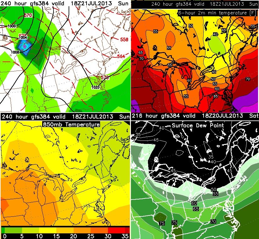
GFS showing a sharp front / trough coming in the long range around the 20th. 850mb temps into the single digits in New England and dewpoints into the 40s. Minimum temps showing 40s but I dont buy GFS minimums in long range

If this happens it will be really refreshing!

Reply With Quote Quick reply to this message
 
Old 07-11-2013, 06:59 PM
nei nei won $500 in our forum's Most Engaging Poster Contest - Thirteenth Edition (Jan-Feb 2015). 

Over $104,000 in prizes has already been given out to active posters on our forum and additional contests are planned
 
Location: Western Massachusetts
45,983 posts, read 53,454,351 times
Reputation: 15184
The center of Wyoming has 850 mb temperatures at 32°C.
Reply With Quote Quick reply to this message
 
Old 07-11-2013, 09:07 PM
 
Location: New Jersey
15,318 posts, read 17,214,623 times
Reputation: 6959
65 F/18 C at 11:05PM with a forecast low of 60 F/16 C...coolest night in some time. Going to try to sleep with the window open and fan on. Looks like 68-70 F/20-21 C lows will be back on the horizon so I guess I should cherish this night.
Reply With Quote Quick reply to this message
 
Old 07-11-2013, 11:32 PM
 
260 posts, read 480,576 times
Reputation: 80
Weather in Ahvaz, Iran, simply great!

Reply With Quote Quick reply to this message
 
Old 07-12-2013, 04:04 AM
 
Location: Kharkiv, Ukraine
2,617 posts, read 3,453,368 times
Reputation: 1106
It's not great, it's hellish...
Reply With Quote Quick reply to this message
 
Old 07-12-2013, 06:14 AM
 
Location: Near the Coast SWCT
83,502 posts, read 75,252,292 times
Reputation: 16619
Steve D write up.


This heat threat is dangerous and is serious. Why? The heat index and these 500 MB heights

The above map is for next Thursday. Note two key points. One, at 500 MB the heart of the ridge will be right over the Philadelphia and New York City metropolitan area. Should this transpire, you have air rapidly sinking over the region. The sinking air will help to suppress thunderstorm development for the most part but also help to enhance surface temperatures as well. Two, the surface high pressure system is locked in off the coast, which means winds at the surface up through 850 MB will be from the southwest, transporting a tropical air mass from the Gulf of Mexico. So why is this dangerous?

Well, when we look at the combined 850 MB temperatures, dew points likely into the lower to mid 70′s, and the sinking air over the region; high temperatures on Tuesday, Wednesday, and Thursday will easily break 90 degrees. My concern is that surface temperatures likely are going to range 95 to 100 degree especially in urban locations. These temperatures combined with high levels of humidity will easily support a heat index over 100 degrees next week.

I strongly advocate to prepare for this heat wave. Have plenty of water available. If possible delay out door activities or at least set aside plenty of breaks in a cool environment. Further, use caution with young children and the elderly in this heat.
Reply With Quote Quick reply to this message
Please register to post and access all features of our very popular forum. It is free and quick. Over $68,000 in prizes has already been given out to active posters on our forum. Additional giveaways are planned.

Detailed information about all U.S. cities, counties, and zip codes on our site: City-data.com.


Reply
Please update this thread with any new information or opinions. This open thread is still read by thousands of people, so we encourage all additional points of view.

Quick Reply
Message:


Over $104,000 in prizes was already given out to active posters on our forum and additional giveaways are planned!

Go Back   City-Data Forum > General Forums > Weather

All times are GMT -6. The time now is 10:39 AM.

© 2005-2024, Advameg, Inc. · Please obey Forum Rules · Terms of Use and Privacy Policy · Bug Bounty

City-Data.com - Contact Us - Archive 1, 2, 3, 4, 5, 6, 7, 8, 9, 10, 11, 12, 13, 14, 15, 16, 17, 18, 19, 20, 21, 22, 23, 24, 25, 26, 27, 28, 29, 30, 31, 32, 33, 34, 35, 36, 37 - Top