Please register to participate in our discussions with 2 million other members - it's free and quick! Some forums can only be seen by registered members. After you create your account, you'll be able to customize options and access all our 15,000 new posts/day with fewer ads.
Well, it looks like cloud cover kept temperatures in the upper 30's across northern Minnesota instead of lower 30's, with the exception of one spot on a temperature map I saw that was around freezing or so. In any case rooftop frost is a cool way to start off June. There's a second chance for frost and freeze tonight, this time extending into northern Wisconsin and the UP. Isolated spots in Minnesota are forecast by the NWS to get down into the 20's.
Quote:
Originally Posted by Cambium
Yup. You're in a prime spot. I'll probably be outside the severe stuff being close to the water..
Here's something I put together.
A look at some select locations past 4 days of max temps.
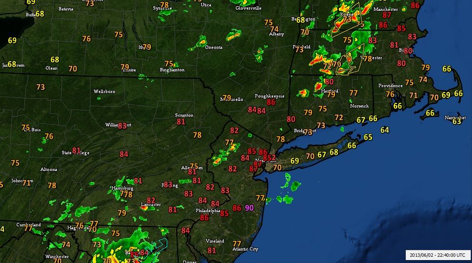
So NYC hit and Bridgeport missed. Of course the NYC numbers mask the huge variation across the metro area, with inland spots reaching the mid 90's and eastern spots struggling to reach 80F. In these situations it's typical for Long Island to be cooler, but it's not every day we see such stark differences across the NYC area.
AT 344 PM EDT...NATIONAL WEATHER SERVICE DOPPLER RADAR WAS TRACKING
STRONG THUNDERSTORMS ALONG A LINE EXTENDING FROM HUNTINGTON TO
RUSSELL TO GRANVILLE TO WINSTED...OR ALONG A LINE EXTENDING FROM 11
MILES SOUTHWEST OF NORTHAMPTON TO 12 MILES WEST OF CHICOPEE TO 13
MILES NORTHWEST OF WINDSOR LOCKS TO 12 MILES NORTHEAST OF
TORRINGTON...AND WAS MOVING EAST AT 35 MPH.
WIND GUSTS UP TO 40 MPH ARE POSSIBLE WITH THESE STORMS ALONG WITH
FREQUENT LIGHTNING.
...THE SEVERE THUNDERSTORM WARNING FOR NORTHWESTERN HAMPDEN AND
WESTERN HAMPSHIRE COUNTIES IS CANCELLED...
THE LINE OF STORMS WHICH PROMPTED THE WARNING HAVE WEAKENED BELOW
SEVERE LIMITS...AND NO LONGER POSE AN IMMEDIATE THREAT TO LIFE OR
PROPERTY. THEREFORE THE WARNING HAS BEEN CANCELLED. HOWEVER GUSTY
WINDS ARE STILL POSSIBLE WITH THESE THUNDERSTORMS.
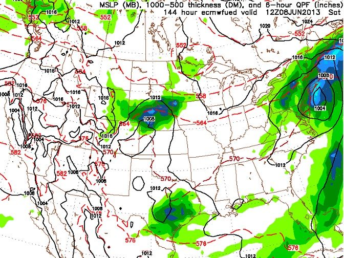
GFS consistantly showing a tropical system in the Gulf affecting FL and SouthEast around the 6-8th timeframe.
Question is where does it go from there? Most of the time its OTS. 1 run I saw it come up the coast and affect the NorthEast. Not a big system but a lot of triopical moisture and some wind
The Euro had been taking it into New Orleans... Lately it has gone the opposite way and now has it coming up the coast agreeing with a few GFS runs.
Take a look at the latest Euro.
Says the Tropical Storm down south comes up the coast.
1004mb is nothing to worry about but a coastal storm with extra tropical characteristics not only will keep us cooler than normal but will send tropical downpours and windy conditions. Looks like this coming weekend might be a washout for some.
AT 912 PM EDT...NATIONAL WEATHER SERVICE DOPPLER RADAR INDICATED A
THUNDERSTORM...PRODUCING STRONG WINDS OVER 35 KNOTS AND PENNY SIZE
HAIL 4 NM NORTHWEST OF OYSTER BAY HARBOR...MOVING EAST AT 20 KT.
* THE THUNDERSTORM WILL BE NEAR...
COLD SPRING HARBOR...STAMFORD HARBOR AROUND 920 PM...
HUNTINGTON BAY...LONG NECK POINT AROUND 930 PM...
NORWALK ISLANDS AROUND 940 PM...
SMITHTOWN BAY AROUND 955 PM...
PENFIELD REEF AROUND 1000 PM...
MARINERS CAN EXPECT GUSTY WINDS...HAIL...HIGH
WAVES...LIGHTNING...AND HEAVY RAINS. BOATERS SHOULD SEEK SAFE HARBOR
IMMEDIATELY...UNTIL THIS STORM PASSES.
FREQUENT LIGHTNING IS OCCURRING WITH THIS STORM. IF CAUGHT ON THE
OPEN WATER STAY BELOW DECK IF POSSIBLE...KEEP AWAY FROM UNGROUNDED
METAL OBJECTS.
GFS should please all of those in search for warm and sunny weather - temperatures reaching 27C by next week, with maxes around 22 - 25C on a widespread basis. Maybe even a 30C if the conditions are right?
Please register to post and access all features of our very popular forum. It is free and quick. Over $68,000 in prizes has already been given out to active posters on our forum. Additional giveaways are planned.
Detailed information about all U.S. cities, counties, and zip codes on our site: City-data.com.

 Please register to participate in our discussions with 2 million other members - it's free and quick! Some forums can only be seen by registered members. After you create your account, you'll be able to customize options and access all our 15,000 new posts/day with fewer ads.


") .
.