Please register to participate in our discussions with 2 million other members - it's free and quick! Some forums can only be seen by registered members. After you create your account, you'll be able to customize options and access all our 15,000 new posts/day with fewer ads.
Hmm...this could end up being one of those "events" that define the season.
Well, not sure about one event defining the season but... All sources (noaa, TWC, Colorado State) point to a very active season.
One reason is, La Nina conditions means less wind shear for the Atlantic which helps development of Tropical storms. The other is blocking continues to show up.
So looks like the U.S coast has higher chances of a hit once again. Anywhere from Texas to Maine is in play.
Before I mention the Canadien model down below, I must say... if this gulf storm doesnt become a Tropical storm, I do not think we'll see a sub 1000mb low off the East coast. It's just going to be rains if anything. But if it gets going in the Gulf then there's a chance this Canadien might be right.
Canadien model showing a 996mb low right over Norfolk VA Friday night & a 998mb low off the NJ coast Saturday morning
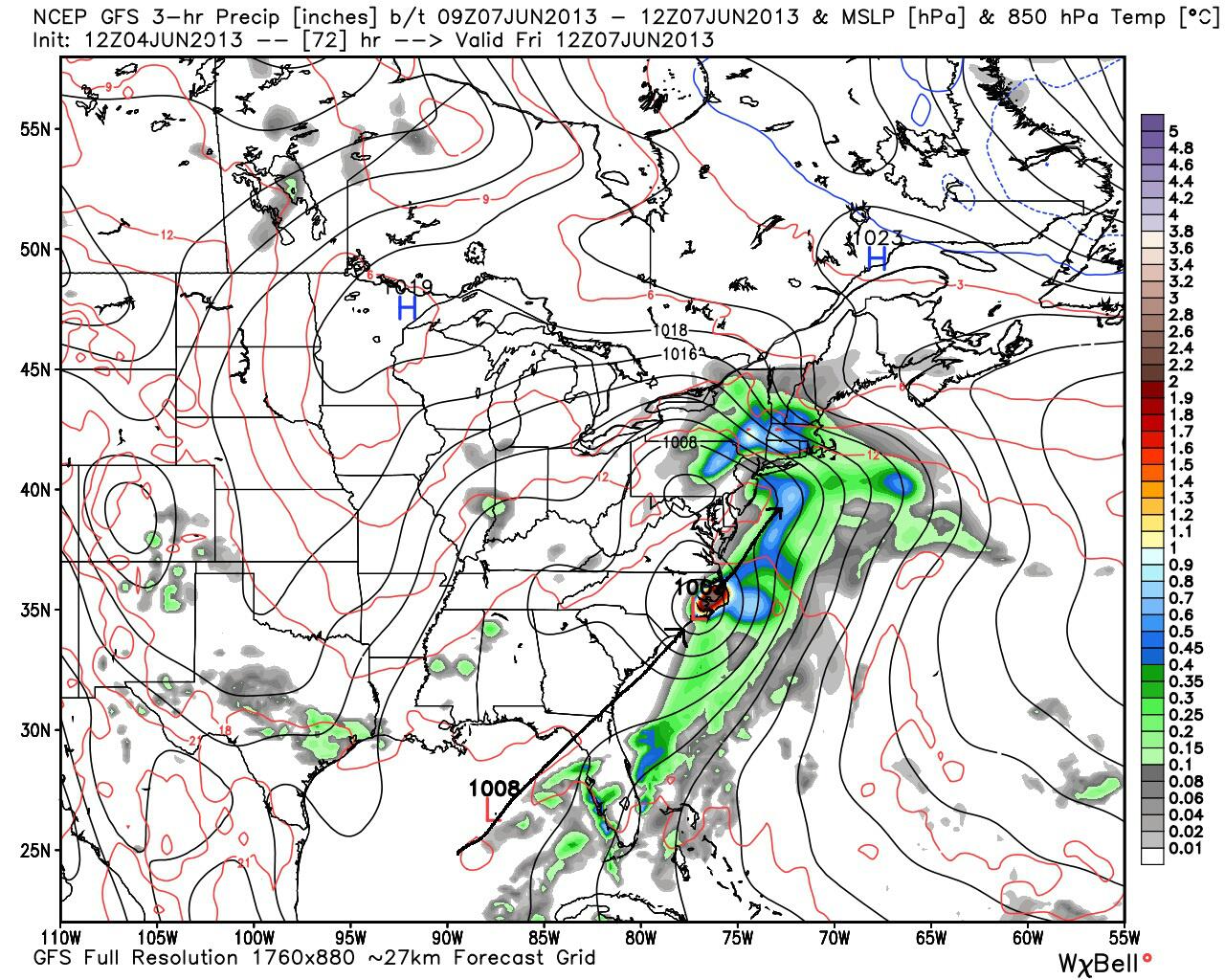
Believe it or not, it looks like the moisture is going to be way before the center of the Low is even nearby. (at least thats what the GFS is hinting at)
This is Friday morning. Its over the NC coast and moisture is feeding back into the NorthEast. But around the circulation its not impressive with moisture. Could be why we're seeing maps and forecasts that show just 1-3" in the Northeast and nothing impressive.
Maybe there won't be too much moisture associated with this low aside from the SE winds pushing some bands back into land?
Latest 12z GFS has it a bit further east off the NJ/Long Island coast
MEDIUM RANGE MODELS CONTINUE TO SIGNAL AN UNUSUALLY ANOMALOUS UPPER
LEVEL PATTERN FOR THIS TIME OF YEAR ACROSS THE LOWER 48...WITH
AMPLIFYING RIDGE BUILDS INTO THE PACIFIC AS H5 TROUGH STARTS TO
DIG ACROSS THE EAST LATER THIS WEEK. THIS HAS IMPLICATIONS FOR
ENHANCED PRECIP PATTERN AS TROPICAL CONNECTION DEVELOPS ALONG THE
EASTERN SEABOARD. THIS WILL TIME JUST RIGHT TO CAPTURE A SYSTEM
THAT DEVELOPS OVER THE GULF OF MEXICO AND BRING IT UP TO COAST IN
THE DIGGING S-SW FLOW UP THE COAST. THIS WILL BRING A VERY DEEP
MOISTURE PLUME TOWARD THE REGION WITH PWATS INCREASING TO 1.7 TO
2 INCHES...ON ORDER OF +2 STANDARD DEVIATIONS ABOVE NORMAL FOR
EARLY JUNE. THIS WILL BRING PERIODS OF HEAVY RAINFALL FROM FRIDAY
AFTERNOON THROUGH MOST OF SATURDAY. STILL SOME QUESTION AS TO
PLACEMENT OF THE HEAVIEST PRECIP DUE TO TRACK OF LOW PRES...BUT
FEEL POTENTIAL IS THERE FOR SOME FLOODING ACROSS PORTIONS OF THE
REGION. HAVE QPF FORECASTED ON ORDER OF 1.5 TO 2.25 INCHES AERIAL
COVERAGE...THOUGH WOULD NOT BE SURPRISED TO SEE SOME MUCH HIGHER
AMOUNTS IN HEAVIER DOWNPOURS. WILL NEED TO MONITOR THIS CLOSELY.
Thanks for posting the discussion. I hope more can do so. It's always nice to come here and read them and see what WFO's are thinking from different areas. To find the closest NWS office near you click here , pick your state, then click forecast discussion. Some states have more than one office who covers them so make sure you scroll down to the right one.
POP QUIZ:
What do Upper level Lows do again? Euro showing one right over the Northeast next week after the coastal storm.
Well, not sure about one event defining the season but... All sources (noaa, TWC, Colorado State) point to a very active season.
I was talking about the summer season in the Northeast, not the Atlantic hurricane season. I'm sure there will be bigger events than this at some point during the hurricane season.
Quote:
Originally Posted by Cambium
What do Upper level Lows do again? Euro showing one right over the Northeast next week after the coastal storm.
That's something that needs to be watched. There's currently an upper level low over Montana that produced 40's and rain yesterday, certainly a chilly way to begin summer. The latest GFS is showing 30's for parts of the Upper Midwest on Thursday, Friday, and Saturday. Will it actually make it down into the 30's? It's an open question, but what is certain is that chilly nights are on the way.
Meanwhile, check out TWC's forecast for Duluth, Minnesota. Tomorrow the temperature is supposed to top out at 42F, which the forecast notes as "cold". No kidding - that's just 5F warmer than the record low of 37F for that date. A high temperature only 5F higher than the record low is definitely quite an event.
Other areas of the Upper Midwest are forecast to have warmer highs than that, but the chill is on in the Northwoods. Out to June 10 it is forecast to remain cooler than normal, though a whole lot warmer than 42F:
I was talking about the summer season in the Northeast, not the Atlantic hurricane season. I'm sure there will be bigger events than this at some point during the hurricane season.
That's something that needs to be watched. There's currently an upper level low over Montana that produced 40's and rain yesterday, certainly a chilly way to begin summer.
Yeah, I'll have to agree with you. If this is the pattern thats setting up, the East coast might be dealing with a lot of Tropical activity.
That ULL over Montana is the one that will swing into the NorthEast. With blocking in place it will be slow to get out.
Please register to post and access all features of our very popular forum. It is free and quick. Over $68,000 in prizes has already been given out to active posters on our forum. Additional giveaways are planned.
Detailed information about all U.S. cities, counties, and zip codes on our site: City-data.com.

 Please register to participate in our discussions with 2 million other members - it's free and quick! Some forums can only be seen by registered members. After you create your account, you'll be able to customize options and access all our 15,000 new posts/day with fewer ads.


 .
.

