Please register to participate in our discussions with 2 million other members - it's free and quick! Some forums can only be seen by registered members. After you create your account, you'll be able to customize options and access all our 15,000 new posts/day with fewer ads.
The one-day heat spike is in the Mid-South, not the Deep South. Think Nashville and Bowling Green, not Houston and Jacksonville .
Quote:
Originally Posted by Cambium
Dont worry, someone will realize Jacksonville Normal highs are 90+ now, so even that forecast after today and tomorrow is "just seasonable/sightly below". LOL! Credit for the effort on his part though.
...boy the next 5 months must be a really tough time for you guys.
Look on the bright side...there is still snow up in the North Pole
Just realized something... Since June's model forecasts are showing status quo (no 90s for Northeast, not many 80s), there's really only 2 more months to get them. July & August. I can live with that.
because come September, especially after beginning of September, chances start dissapearing fast. Nice.
Looks like after Friday, we'll get more seasonable temperatures and drier air. How about some sun and afternoons in the high 70s are a few week? Not too much to ask for in June, right? The ground needs a break and I want warmth and sun:
AS THE GROUND IS QUITE SATURATED...FORECAST TOTAL RAINFALL
AMOUNTS OF 2 TO 4 INCHES...LOCALLY HIGHER IN SPOTS...WILL RESULT
IN AREAS OF SIGNIFICANT URBAN AND LOW-LYING FLOODING. IN
ADDITION...SMALL STREAMS AND CREEKS ALREADY SWOLLEN FROM RECENT
RAINS WILL LIKELY SWELL AGAIN IN SOME CASES OUT OF THEIR BANKS
AND ABOVE FLOOD STAGE. MAIN-STEM RIVERS MAY ALSO RISE OUT OF
THEIR BANKS AND ABOVE FLOOD STAGE.
Just realized something... Since June's model forecasts are showing status quo (no 90s for Northeast, not many 80s), there's really only 2 more months to get them. July & August. I can live with that.
because come September, especially after beginning of September, chances start dissapearing fast. Nice.
I love how cold weather fans try to hard to tell themselves little fables to get through the long hot summer
Not only are 80's forcecasted at most NWS stations in the Tri-State/Middle Atlantic right to the end of the month (and areas of the Tri-State have already HAD 90's F)....but 90's F are WAY more common in July and August in the Tri-State area (and in most areas of the USA) than June.
As far as September and no more 90's....hmmm.....the data says otherwise: The record high for EVERY SINGLE day in September at NWS NYC is in the 90's F.
Then of course, there is the fact that the LONGEST heat wave in NYC HISTORY was at the end of August into eary Setember:
CWF should look on the bright side....winter/cold/snow...is only 6 months away
I love how cold weather fans try to hard to tell themselves little fables to get through the long hot summer
Well it is true. If this month continues on the current average track, the heat will be pretty benign. Then we only have to deal with the worst of summer for July and August. Of course September can and most likely will get hot at some point, but the "downward spiral" begins.
Quote:
Originally Posted by wavehunter007
Not only are 80's forcecasted at most NWS stations in the Tri-State/Middle Atlantic right to the end of the month (and areas of the Tri-State have already HAD 90's F)....but 90's F are WAY more common in July and August in the Tri-State area (and in most areas of the USA) than June.
No 80s where I live. I don't see any for NYC either in the upcoming forecast. It looks like Newark will barely scrape 80 F this upcoming week. Average high this time of year in Newark is over 80 F...NYC upper 70s to around 80 F. High temperatures will be 5-10 F below average the next couple of days with the rain.
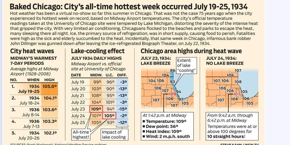
Our longest heatwave here in Chicago of course happened during the Dust Bowl years of the 1930's
[/url]
Please register to post and access all features of our very popular forum. It is free and quick. Over $68,000 in prizes has already been given out to active posters on our forum. Additional giveaways are planned.
Detailed information about all U.S. cities, counties, and zip codes on our site: City-data.com.

 Please register to participate in our discussions with 2 million other members - it's free and quick! Some forums can only be seen by registered members. After you create your account, you'll be able to customize options and access all our 15,000 new posts/day with fewer ads.

") .
.


 July & August. I can live with that.


 [/url]