Welcome to City-Data.com Forum!
U.S. CitiesCity-Data Forum Index
Go Back   City-Data Forum > General Forums > Weather
 [Register]
Please register to participate in our discussions with 2 million other members - it's free and quick! Some forums can only be seen by registered members. After you create your account, you'll be able to customize options and access all our 15,000 new posts/day with fewer ads.
View detailed profile (Advanced) or search
site with Google Custom Search

Search Forums  (Advanced)
Reply Start New Thread
 
Old 06-29-2012, 10:17 AM
 
Location: Near the Coast SWCT
83,520 posts, read 75,307,397 times
Reputation: 16619

Advertisements

Noon temps with 850H lines. Reason why it wont be as bad as last time in the NorthEast is because the Ridge top is flatter AND south more. The Triple digit real feel will stay south and the upper 90s wont be widespread like last time up this way

Reply With Quote Quick reply to this message

 
Old 06-29-2012, 10:23 AM
 
Location: Near the Coast SWCT
83,520 posts, read 75,307,397 times
Reputation: 16619
Umm, any thoughts on this?

First thing that came to my mind was... "Global Warming Stat Errors" now this location will show this spike in temp unless they fix it.... or do you think its actual?

National Weather Service Forecast Office - Upton, NY

Reply With Quote Quick reply to this message
 
Old 06-29-2012, 10:48 AM
 
Location: Upstate, South Carolina
356 posts, read 677,495 times
Reputation: 155
humidity at GSP right now is 23%. 98 degrees with a real feel of 96.. amazing how dry this heatwave is for this area
Reply With Quote Quick reply to this message
 
Old 06-29-2012, 10:54 AM
 
Location: The canyon (with my pistols and knife)
14,186 posts, read 22,747,384 times
Reputation: 17398
According to The Weather Channel, it's 99 degrees in Athens, GA and 93 degrees in Pittsburgh, as of 12:30PM EDT.

UPDATE: As of 1:00PM EDT, Athens has its first 100-degree day of 2012, with a temperature of 101 degrees. Pittsburgh is now at 94. I doubt it'll reach 100 degrees there, but 97 or 98 wouldn't surprise me.

UPDATE: As of 2:00PM EDT, the termperature is 103 degrees in Athens, and 97 in Pittsburgh, according to The Weather Channel. Regardless of where the temperature goes from here, June 29, 2012 is the hottest day in Pittsburgh since the temperature topped 100 degrees on July 15, 1995.

Last edited by Craziaskowboi; 06-29-2012 at 12:18 PM.. Reason: Hourly temperature update
Reply With Quote Quick reply to this message
 
Old 06-29-2012, 10:59 AM
 
Location: Laurentia
5,576 posts, read 7,999,569 times
Reputation: 2446
I doubt if it's the actual temperature. Most likely an error.
Reply With Quote Quick reply to this message
 
Old 06-29-2012, 11:06 AM
 
Location: Bellingham, WA
9,726 posts, read 16,742,163 times
Reputation: 14888
These maps are the stuff of nightmares. My nightmares, anyway.
Reply With Quote Quick reply to this message
 
Old 06-29-2012, 11:56 AM
 
Location: Near the Coast SWCT
83,520 posts, read 75,307,397 times
Reputation: 16619
Quote:
Originally Posted by Gnutella View Post
According to The Weather Channel, it's 99 degrees in Athens, GA and 93 degrees in Pittsburgh, as of 12:30PM EDT.

UPDATE: As of 1:00PM EDT, Athens has its first 100-degree day of 2012, with a temperature of 101 degrees. Pittsburgh is now at 94. I doubt it'll reach 100 degrees there, but 97 or 98 wouldn't surprise me.
105 at Columbia Airport in South Carolina. Dew point at 55.
Reply With Quote Quick reply to this message
 
Old 06-29-2012, 12:14 PM
 
Location: Indiana Uplands
26,411 posts, read 46,581,861 times
Reputation: 19559
I saw the writing on the wall years ago and decided that I had to move much further north to escape the brutality of summer heat in the southern 1/2 to 2/3 of the country these days. These heat waves are becoming much more common with a duration that is far longer. It's the new normal and it isn't going to be pretty.
Reply With Quote Quick reply to this message
 
Old 06-29-2012, 01:03 PM
 
Location: Near the Coast SWCT
83,520 posts, read 75,307,397 times
Reputation: 16619
Quote:
Originally Posted by nei View Post
Mind explaining how that works? Does the humid air settle at ground level in the air or something?
.
Upton has a nice technical discussion out. National Weather Service Text Product Display

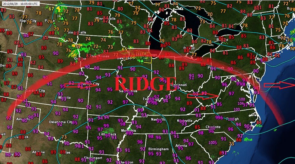
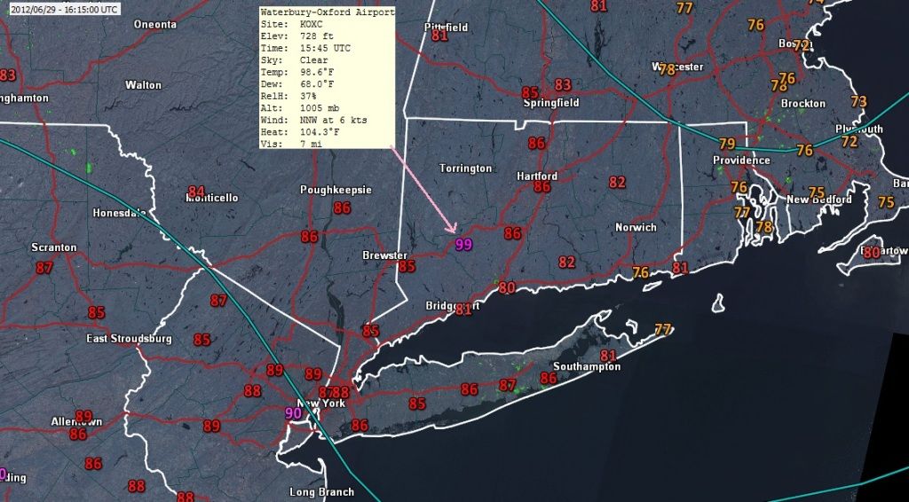
In short, they are saying the cold front is too weak to know exactly where it is right now. They dropped the temp forecast a degree or two because of the storm that came through this morning, 850mb temps are Hot so 100° NYC southwards and around 90° elsewhere along the coast. (just like I been saying for a week)

-----------------------------------------
NEAR TERM /UNTIL 6 PM THIS EVENING/...

9 AM UPDATE: CONVECTIVE DEBRIS IS NOW PRESSING EAST...LEAVING
SUNNY SKIES FOR THE REST OF THE DAY. COLD FRONT IS DIFFICULT TO
PINPOINT AT THIS TIME...BUT APPEARS TO BE JUST NW OF ORANGE
COUNTY
. THIS DIFFUSE FRONT WILL BASICALLY FALL INTO THE THERMAL
TROUGH THIS AFTERNOON RESULTING IN NW FLOW AND LOWERING DEW
POINTS.

PSEUDO SEA BREEZE ON LONG ISLAND AND SE CT DEVELOPS MAINLY IN
RESPONSE TO THE THERMAL TROUGH
.

ONLY MINOR DOWNWARD ADJUSTMENT OF TEMPS A DEGREE OR SO TO ACCOUNT
FOR INCREASED GROUND MOISTURE FROM MCS THIS MORNING.
OTHERWISE...WITH 850 MB TEMPERATURES OF 21-23C THIS
AFTERNOON...HIGHS WILL RANGE FROM AROUND 100 ACROSS PARTS OF NE NJ
AND NYC TO AROUND 90 ALONG THE IMMEDIATE SOUTHERN AND EASTERN LONG
ISLAND AND CT COASTS. SOME RECORDS ARE FORECAST TO BE TIED OR
BROKEN. SEE CLIMATE SECTION BELOW.

SURFACE DEW POINT TEMPERATURES FORECAST IS A LITTLE TRICKY.
THINKING REMAINS THAT THE DRIER AIR ALOFT MOVES IN HERE IN TIME TO
ALLOW SURFACE DEW POINT TEMPS TO DROP DURING PEAK HEATING LATE
THIS AFTERNOON. WNW SURFACE WINDS SHOULD HELP THIS AS WELL. HEAT
INDEX VALUES THEREFORE END UP CLOSE TO AMBIENT TEMPERATURES...THUS
HEAT ADVISORY FOR NYC AND PARTS OF NE NJ REMAIN IN PLACE. THERE
COULD BE AREAS ROCKLAND...WESTCHESTER...FAIRFIELD AND THE NORTH
SHORE OF LONG ISLAND WHERE INDICES CLIMB TO NEAR 100...BUT NOT
WIDESPREAD ENOUGH TO INCLUDE IN THE ADVISORY.


&&

.SHORT TERM /6 PM THIS EVENING THROUGH 6 PM SATURDAY/...
NAM/MAV MOS BLEND USED FOR LOW TEMPERATURES TONIGHT WITH UPWARD
ADJUSTMENTS TO THE CITY TO ACCOUNT FOR THE HEAT ISLAND EFFECT.

ON SATURDAY...FLOW ALOFT IS ZONAL...AND AT THE SURFACE...PERHAPS A
SOME THERMAL TROUGHING OVER/NEAR THE AREA. COLUMN STILL RATHER DRY
DURING THE MORNING WITH SOME MOISTURE INCREASE LATE IN THE DAY.
PERHAPS SOME LIFT LATE AS WELL WITH AN APPROACHING SHORTWAVE...BUT
THINKING IS THAT WE JUST MAKE IT THROUGH THE AFTERNOON HOURS DRY.

EXPECTING 850 MB TEMPERATURES OF 19-20C IN THE AFTERNOON WITH
DEWPOINTS AT THIS LEVEL RISING TO AROUND 12-13C BY LATE IN THE DAY.
BOUNDARY LAYER WIND SPEEDS LIKELY ALLOW A SEA BREEZE TO
DEVELOP...HOWEVER...AS SEEN WITH THE PREVIOUS WAVE OF
HEAT...GUESSING THAT TEMPERATURES WILL BE ABLE TO RISE A FEW HOURS
AFTER THE SEA BREEZE PASSES THROUGH. LOOKING AT HIGHS IN THE MID TO
UPPER 90S FOR THE HOTTEST AREAS AWAY FROM THE COAST. FOR THE COASTAL
AREAS...HIGHS STILL IN THE LOW 90S AWAY FROM THE IMMEDIATE SOUTH
FACING SHORES
. FORECAST DEWPOINTS ALOFT SHOULD PREVENT SIGNIFICANT
RISING OF SURFACE DEWPOINTS THROUGH AT LEAST THE EARLY
AFTERNOON...BUT BOTH NAM/MAV MOS GUIDANCE SHOWING THEM INCREASING
LATE IN THE DAY. CONSIDERING WHAT MIXES DOWN FROM ALOFT...NAM
DEWPOINTS LOOK TOO HIGH...ESPECIALLY FOR AREAS UNAFFECTED BY THE SEA
BREEZE. WENT CLOSER THE MAV MOS NUMBERS. THIS RESULTS IN HEAT
INDICES REACHING LOCAL CRITERIA LEVELS FOR NYC. WILL EXPAND THE
DURATION OF THE HEAT ADVISORY FOR THE CITY DURING SATURDAY BY A FEW
HOURS.
Reply With Quote Quick reply to this message
 
Old 06-29-2012, 01:05 PM
 
Location: Near the Coast SWCT
83,520 posts, read 75,307,397 times
Reputation: 16619
Quote:
Originally Posted by GraniteStater View Post
I saw the writing on the wall years ago and decided that I had to move much further north to escape the brutality of summer heat in the southern 1/2 to 2/3 of the country these days. These heat waves are becoming much more common with a duration that is far longer. It's the new normal and it isn't going to be pretty.
I respect and envy you. I have been talking about doing this for many years now... waiting for right moment. .. It's not that they've gotten worse or longer in duration, I just seem to tolerate it less each year.
Reply With Quote Quick reply to this message
Please register to post and access all features of our very popular forum. It is free and quick. Over $68,000 in prizes has already been given out to active posters on our forum. Additional giveaways are planned.

Detailed information about all U.S. cities, counties, and zip codes on our site: City-data.com.


Reply
Please update this thread with any new information or opinions. This open thread is still read by thousands of people, so we encourage all additional points of view.

Quick Reply
Message:


Over $104,000 in prizes was already given out to active posters on our forum and additional giveaways are planned!

Go Back   City-Data Forum > General Forums > Weather

All times are GMT -6. The time now is 04:49 PM.

© 2005-2024, Advameg, Inc. · Please obey Forum Rules · Terms of Use and Privacy Policy · Bug Bounty

City-Data.com - Contact Us - Archive 1, 2, 3, 4, 5, 6, 7, 8, 9, 10, 11, 12, 13, 14, 15, 16, 17, 18, 19, 20, 21, 22, 23, 24, 25, 26, 27, 28, 29, 30, 31, 32, 33, 34, 35, 36, 37 - Top