Please register to participate in our discussions with 2 million other members - it's free and quick! Some forums can only be seen by registered members. After you create your account, you'll be able to customize options and access all our 15,000 new posts/day with fewer ads.
I think you need to clarify that the daily averages are not running anywhere that far below normal, at least not in Jackson, MS nor Vicksburg. The nightly lows, due to radiational cooling, are running further below normal than the daily high temps.
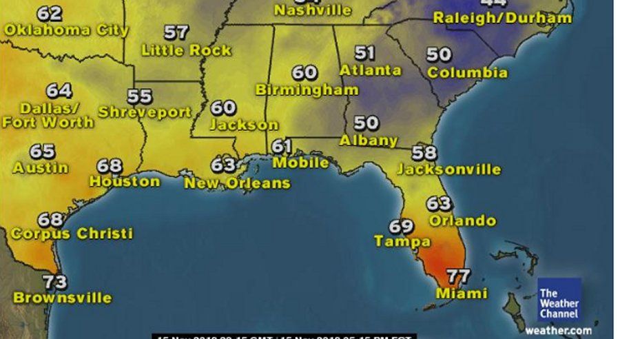
Normal high/low for Jackson, MS is 68/44f, yesterday. This coming weekend around 67/43. The forecast isn't anywhere near 20f below normal. By Monday, their temps will be above normal. If anything, the temps have ranged from 0 to 11f below normal, on the daily average temp, not 10-20f.
Vicksburg, MS, seems to run much cooler at night than a lot of other places nearby. Even Vicksburg hasn't been near 20f below normal. The low temps there, due to radiational cooling run further below normal than the high temps. But the daily average isn't running 20f below normal.
I wish Philly had this forecast coming up. Here everyone would be out and about talking about how warm.
Exactly.
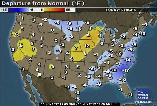
I admit 100% I'm a WWF....but the departures are not that great in the southland. Also, the rest of the USA has no below normal cold forecast for the rest of November. That seems not to get mentioned as well. Cam seems to be looking hard to find a very cold pattern seting up in the USA (it is geting on toward the start of meterological winter on December 1st)....and other than a few cool departures in the south (a warm region anyway) there are none to find.
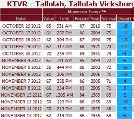
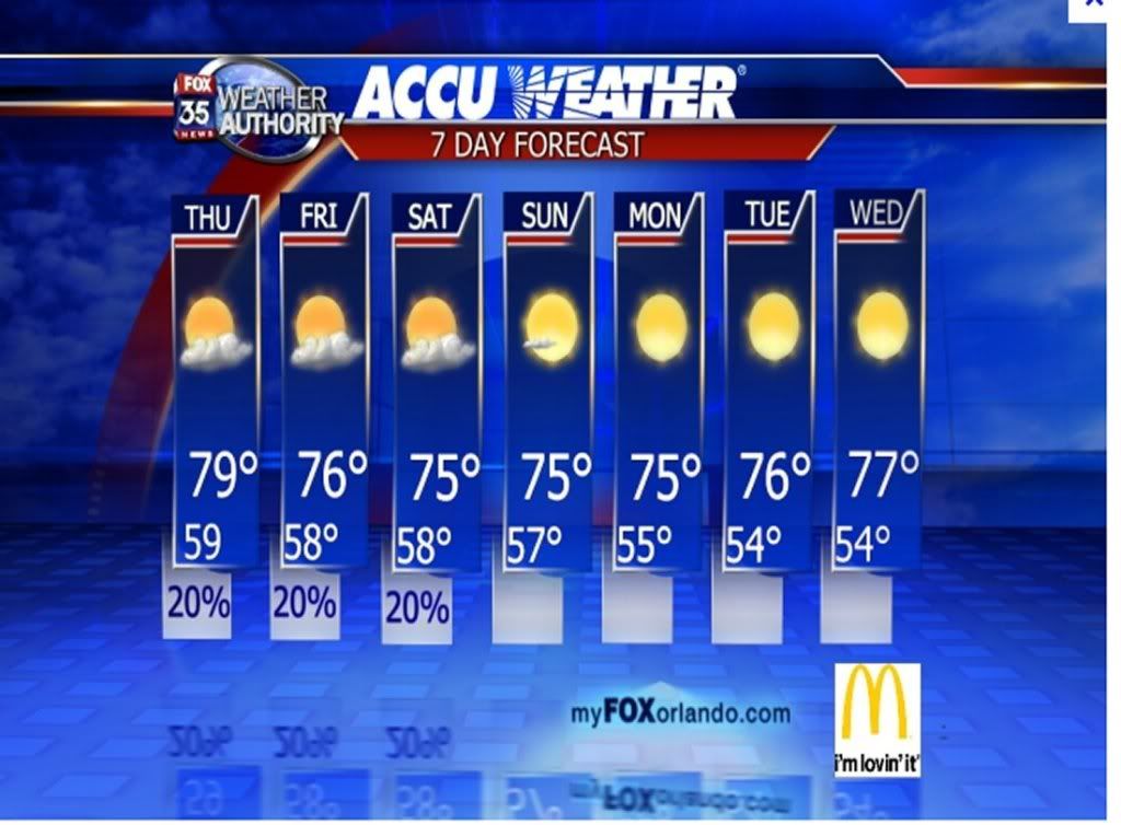
Cam has been waiting since the front went thorugh yesterday (and we had a few cool days/nights) to try to force the issue that the USA is now in a cold winter pattern. Not true. Also, there has been attempt to try to find stations only in the uppper south or off the coastal plain to make it seem colder than it really is. Here is a forecast for a location in Louusina... they will struggle to have lows that go below 50 F...and highs will head into the 70's :
The pattern is normal for the USA this time of year...
Last edited by wavehunter007; 11-15-2012 at 04:31 PM..
I think you need to clarify that the daily averages are not running anywhere that far below normal, at least not in Jackson, MS nor Vicksburg. The nightly lows, due to radiational cooling, are running further below normal than the daily high temps.
Vicksburg, MS, seems to run much cooler at night than a lot of other places nearby. Even Vicksburg hasn't been near 20f below normal. The low temps there, due to radiational cooling run further below normal than the high temps. But the daily average isn't running 20f below normal.
No matter how hard you try......
Can't wait to hear this one. Hey look... High temps...must be that nighttime radiational cooling.
Normal high in the 70s and they are just getting to 50s and 60s. Hmmm.. Gotta be that warm pattern there.
I enjoyed reading Cambium vs. Wavehunter. The fact is that a huge chunk of the country has had colder than normal weather this month, and there have been quite a few early season winter storms and cold outbreaks. There have been outbreaks of warm air as well, but they were lesser in intensity and duration than the cold periods. A more normal temperature pattern seems to be setting up, but it's not much of a pattern flip. "Seasonably cool" seems to be the best description for the rest of the month, at least up until the last few days of the month, when there could be a potent storm.
As for the start to meteorological winter, models seem to be having a hard time grasping the pattern. A lot of strong pressure systems keep popping up, which might be confounding the forecasts. Extreme cold isn't indicated by any model, but quite a few in the long range do have outpourings of cold air to a lesser degree (just because there isn't a huge arctic outbreak doesn't mean that there will be "no below normal temps"). No model that I've seen has a really warm start to winter, either, so at this point I'd peg the early December pattern as being anywhere from "moderate cold" to "slight warmth". We'll just have to wait and see: only the first few days of December are within model range, and right now they're in the 300+ hour range, which carries a large degree of uncertainty.
I'm speaking for the bulk of the United States here. Some spots in the Northeast or another region may deviate from what I said here.
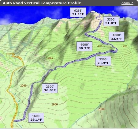
Check this out guys.. Pretty cool to see. This is called a Capping Inversion. When its colder at the surface but because of a cap it gets warmer at the layer above.
Notice its 26 degrees at the surface and as you climb the temp drops as usual. 23 degrees at 3300'. ..But notice as you climb past that it gets warmer. Its 31 degrees at 6288'.
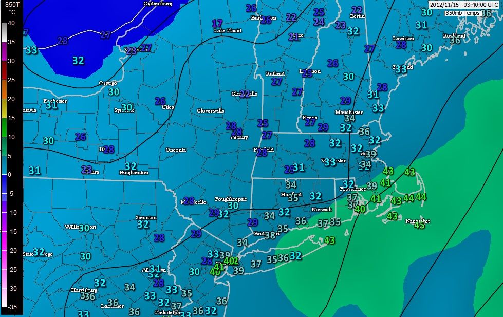
In fact, take a look... A quick check of the 850mb temps around the area... 10:45pm.
While temperatures are below freezing at the surface, the layer above is warm. Light blue and green background showing 5000' temps in the 30s and in the 40s where its green background. Numbers are surface temps
This would mean an ice storm in this type of senario if there was precip falling. Fascinating stuff.
Please register to post and access all features of our very popular forum. It is free and quick. Over $68,000 in prizes has already been given out to active posters on our forum. Additional giveaways are planned.
Detailed information about all U.S. cities, counties, and zip codes on our site: City-data.com.

 Please register to participate in our discussions with 2 million other members - it's free and quick! Some forums can only be seen by registered members. After you create your account, you'll be able to customize options and access all our 15,000 new posts/day with fewer ads.


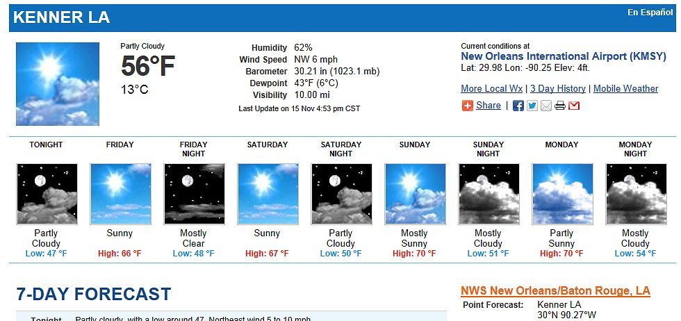


") Hey look... High temps...must be that nighttime radiational cooling.
Hey look... High temps...must be that nighttime radiational cooling.