Please register to participate in our discussions with 2 million other members - it's free and quick! Some forums can only be seen by registered members. After you create your account, you'll be able to customize options and access all our 15,000 new posts/day with fewer ads.
Actually, that may be the average but we do often have Ice Days and 1/2 weeks or so of constant snow cover. When I say cool down properly I mean temperatures of 0/1c and sharp frosts with snow cover.
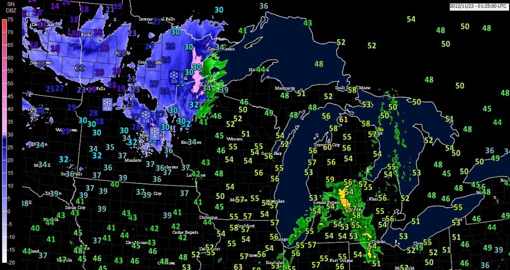
Morning temps across the U.S. I wonder what the normal lows are in Florida for mid November. Don't forget... 1 or 2 numbers here doesnt mean 1 backyard. Its a whole city/area around it.
In northern Florida about 48°F lows are normal in the panhandle and 50°F around Jacksonville.
If November ended today we would have the coldest November in 9 years(since 2002) for Bridgeport,CT and 4 years for BDL(Windsor Locks, CT).
2007 & 2008 had cold Novembers for BDL but this November is not beating those years so far.. .
The coldest November was 1962. The warmest was 1975.
Are you kidding? When I say that, I'm not doubting you, but that map doesn't look that cold. You must have had some very warm Novembers the past few years.
Finally some colder weather here in Grand Forks ND today.... 18 at 7 pm this Thanksgiving night had inch or two of snow and blowing snow. Nothing too bad....but hampering travel some.
Behind the front teens, ahead of it 50s. Lakes will be in full effect this weekend
heavy band on Lake Superior right now
I noticed very mild 58F at Sault Ste. Marie....it was Ontario hotspot today with 17.2c (63F) high temp!
Actually Sault Ste. Marie had warmest temp in all of Canada today
Way above normal, I'm thinking their normal high would be 2c (36F?)
As far south as Herkimer County NY will get the Lake Effect snow accumulations and be Cold.
IN THE WAKE OF THE FRONT...TEMPS WILL BE MUCH COLDER FOR THE
WEEKEND. AS 850 HPA TEMPS DROP TO -10 TO -13 DEGREES C...MAX TEMPS
ON BOTH SAT AND SUN WILL ONLY REACH THE 30S TO NEAR 40 IN MOST
VALLEY AREAS...WITH TEMPS STAYING BELOW FREEZING ACROSS THE HIGH
TERRAIN.MIN TEMPS ON SAT NIGHT WILL BE COLD WITH TEENS AND 20S.
IN ADDITION...A BRISK NW WINDS OVER THE WEEKEND WILL MAKE IT FEEL
EVEN COLDER...WITH A FEW GUSTS ON SAT AFTN TO AROUND 30-35
MPH...ESP IN THE HIGHER TERRAIN.
WITH THIS COLD AIR MOVING INTO THE REGION...SOME LAKE EFFECT SNOW
WILL BE POSSIBLE FOR FAR WESTERN AREAS FOR SATURDAY INTO SUNDAY.
WITH A WIND DIRECTION OF 295-305 DEGREES /NW/ EXPECTED FOR THE
LOWEST FEW THOUSAND FEET OF THE ATMOSPHERE...THE BULK OF THE MULTI
BAND LAKE EFFECT SNOW SHOWERS WILL REMAIN TO THE WEST OF OUR
REGION ACROSS CENTRAL NEW YORK FOR SATURDAY AFTN INTO SUNDAY.
STILL...A FEW BATCHES OF SNOW SHOWERS WILL SCRAPE THE WESTERN
ADIRONDACKS AND WESTERN MOHAWK VALLEY...ESP ON SAT MORNING AS THE
FLOW INITIALLY SHIFTS FROM W TO NW. SOME LIGHT ACCUMULATION OF AN
INCH OR TWO IS POSSIBLE FOR SOUTHERN HERKIMER COUNTY ON SATURDAY
BEFORE THE BANDS SHIFT AWAY FROM THE REGION. ELSEWHERE...SOME
INSTABILITY/UPSLOPE FAVORED SNOW SHOWERS ARE POSSIBLE IN THE
HIGHER TERRAIN AREAS OVER THE WEEKEND WITH THE UPPER TROUGH
OVERHEAD...BUT LITTLE TO NO ACCUMULATION IS EXPECTED. THE CAPITAL
REGION/HUDSON VALLEY SHOULD REMAIN DRY OVER THE WEEKEND WITH A
PARTLY TO MOSTLY CLOUDY SKY AND THE BRISK TEMPS/WIND IN PLACE
Please register to post and access all features of our very popular forum. It is free and quick. Over $68,000 in prizes has already been given out to active posters on our forum. Additional giveaways are planned.
Detailed information about all U.S. cities, counties, and zip codes on our site: City-data.com.

 Please register to participate in our discussions with 2 million other members - it's free and quick! Some forums can only be seen by registered members. After you create your account, you'll be able to customize options and access all our 15,000 new posts/day with fewer ads.


")