Fall 2012 Thread (September - November) (warm, ice, warming, temperature)
Please register to participate in our discussions with 2 million other members - it's free and quick! Some forums can only be seen by registered members. After you create your account, you'll be able to customize options and access all our 15,000 new posts/day with fewer ads.
15" of snow Just from Lake Effect: Gotta love that. I've always been facinated with Lake Effect. Coastal storms are not the only way to get over a foot of snow. And its always interesting how Lakes can generate it.
Interesting how you picked this as it's only a few miles from me. It snowed most of the night and the plows kept running. Roads look good. Calling for off and on lake effect all week long until a warm ridge builds in for next weekend, but NWS says it won't last long as another cold dome from Canada is set to drop down for the next round of snow. As long as we can keep these Alberta clippers moving through we will have a nice set up for snow to keep things interesting.
Truly excellent weather for cross-country running (what I have just been doing) here this morning: 5 degrees C, fog, drizzle, gloom, and a course largely consisting of puddles, mud, slippery fallen leaves and tree branches blown off in the wind the other night. You can keep your San Diegos and your Canary Islands, seriously...
Ha reminds me of high school. Running through the woods in such conditions at 8AM.
Been quite windy here since last night. Apparently there were flurries this morning. Now mostly overcast and windy with a temperature of 40 F/4 C at 1PM. Windchill is 33 F/1 C. Classic November weather.
US National Weather Service New York NY
Visible satellite showed some interesting cloud formations around the region this afternoon. Despite their peculiar appearance, the formative mechanisms behind cloud streets and waves are relatively well understood. Take a look at the associated graphic
Both Wunderground and Accuweather report normal highs for Ft. Collins to be around 45° F. for this time of year. Denver is a little warmer. The avg. low is 22°, and we hit 28° last night. I'm right up against the mountains, so variability can be much the norm. Temperatures can drop 50 degrees in just a few hours, but can parenthetically rise that much when the winds blow west down from the mountains. I'm more than ready for a pattern change, can you tell?
My normal highs here on the CT coast is all that much different than yours - mine is 49 F as of today. My low is 38 F however. If your low is 22 F now, what is it in late January?
My normal highs here on the CT coast is all that much different than yours - mine is 49 F as of today. My low is 38 F however. If your low is 22 F now, what is it in late January?
Actually, we bottom out in late Dec. here, where the lows average 14°. This is an average, and we haven't seen any average for a long time. At 5,000 feet, and with very dry air, things can cool off in a hurry if we don't have those westerly winds. The diurnal range is significant, and the temperatures can also drop significantly when moisture arrives, a phenomena that we have discussed before.
My normal highs here on the CT coast is all that much different than yours - mine is 49 F as of today. My low is 38 F however. If your low is 22 F now, what is it in late January?
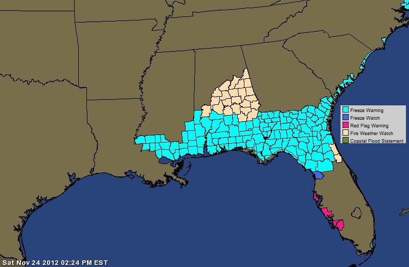
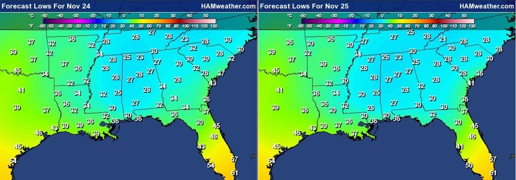
...CHILLY TEMPERATURES WILL ENCOMPASS A SIGNIFICANT SECTION OF THE CONUS...
...LAKE EFFECT SNOWS ARE EXPECTED TO IMPACT THE MAJOR GREAT LAKES THROUGH MONDAY...
THE OVERALL PATTERN ACROSS THE U.S. WILL BE RATHER CHILLY AS
MODIFIED ARCTIC AIR HAS WORKED ITS WAY SOUTHWARD FROM CENTRAL
CANADA. A STRONG COLD FRONT HAD EARLIER SWEPT OFF THE EASTERN
SEABOARD LAST NIGHT WHICH USHERED IN THESE COLD TEMPERATURES. IN
ADDITION...THE SURFACE LOW ASSOCIATED WITH THIS SYSTEM HAS
STRENGTHENED SIGNIFICANTLY THEREBY ENHANCING THE OVERALL WIND
FIELD ACROSS THE NORTHEASTERN TIER OF THE COUNTRY. THIS
COMBINATION OF BELOW NORMAL TEMPERATURES AND BREEZY CONDITIONS
WILL MAKE IT FEEL QUITE A BIT COLDER TO CONCLUDE THE WEEKEND.
ADDITIONALLY...THE SYNOPTIC PATTERN SHOULD REMAIN CONDUCIVE FOR
LAKE EFFECT SNOW PRODUCTION DOWNWIND OF ALL OF THE GREAT LAKES.
DEEP-LAYERED WESTERLY FLOW WILL BE SUSTAINED AS THE ARCTIC AIR
OVERRIDES THE STILL MILD LAKE WATERS. THIS SHARP TEMPERATURE
GRADIENT ABOVE THE LAKE SURFACE SHOULD LEAD TO VIGOROUS LIFT
SPAWNING NUMEROUS SNOW SHOWERS DOWNWIND OF THE LAKES. FURTHER
SUPPORT WILL ALSO BE IN PLACE AS A RATHER WEAK FRONTAL SYSTEM
CROSSES THE GREAT LAKES ON SUNDAY. OVERALL...HPC THE WINTER
WEATHER DESK IS ADVERTISING A WIDESPREAD 2 TO 4 INCHES OF SNOWFALL
OVER THE GREAT LAKES REGION WITH POCKETS OF HEAVIER AMOUNTS NEARBY
LAKES SUPERIOR AND HURON.
AS THE UPPER PATTERN IS FORECAST TO PRIMARILY CONSIST OF A TROUGH
FROM THE INTERMOUNTAIN WEST ALL THE WAY TO THE EAST COAST...A
NUMBER OF DISTURBANCES ALOFT ARE FORECAST TO DROP DOWN FROM
WESTERN CANADA TOWARD THE INTERIOR WEST. MID-LEVEL ENERGY
ACCOMPANYING THESE IMPULSES WITH THE ADDED CONTRIBUTION OF UPSLOPE
FLOW WILL RESULT IN SNOW OVER THE HIGHER TERRAIN OF CENTRAL IDAHO
EASTWARD TO THE NEBRASKA PANHANDLE. THE HEAVIEST AMOUNTS SHOULD
CONGREGATE OVER THE GRAND TETONS ALONG WITH THE BIGHORNS WITH UP
TO A FOOT OF SNOW POSSIBLE ACROSS THE FORMER.
LOOKING DOWN TO THE WESTERN GULF COAST...LIGHT SHOWERS SHOULD
BREAK OUT BY EARLY NEXT WEEK AS RETURN FLOW COMMENCES FROM THE
GULF OF MEXICO. THIS SHOULD ALSO ALLOW HIGH TEMPERATURES TO REBOUND BACK INTO THE UPPER 70S BY MONDAY.IN STARK CONTRAST...THE UPPER MIDWEST WILL STRUGGLE TO GET OUT OF THE TEENS FOR A HIGH ON THE SAME DAY.
Well, after a relatively benign and dry month, our first proper heavy rain since September has arrived.. I've been watching the radar animation, and this isn't going anywhere anytime soon. Thankfully, no chance at all of flooding here. Feel sorry for the people in the SW.
And the system behind it.. nice circular shape.
Last edited by dunno what to put here; 11-24-2012 at 10:48 PM..
Why does the GFS always underestimate the Temperatures for Norther Ireland?
No way is there going to be a 12c difference in Temperature between 90 miles. Every time there is a cold spell it does this. But I don't know why. Its always wrong. During the 2010 cold spell it was predicting -7c mins and we were down to -19c.
It is also giving Scotland several Ice Days while keeping us 7c warmer. First off, Dumfries and the like isn't really that much colder than us and secondly, Castlederg recorded the coldest UK max yesterday. I don't think anywhere in lowland Scotland has recorded an Ice day yet.
Please register to post and access all features of our very popular forum. It is free and quick. Over $68,000 in prizes has already been given out to active posters on our forum. Additional giveaways are planned.
Detailed information about all U.S. cities, counties, and zip codes on our site: City-data.com.

 Please register to participate in our discussions with 2 million other members - it's free and quick! Some forums can only be seen by registered members. After you create your account, you'll be able to customize options and access all our 15,000 new posts/day with fewer ads.