Welcome to City-Data.com Forum!
U.S. CitiesCity-Data Forum Index
Go Back   City-Data Forum > General Forums > Weather
 [Register]
Please register to participate in our discussions with 2 million other members - it's free and quick! Some forums can only be seen by registered members. After you create your account, you'll be able to customize options and access all our 15,000 new posts/day with fewer ads.
View detailed profile (Advanced) or search
site with Google Custom Search

Search Forums  (Advanced)
 
 
Old 11-27-2012, 12:54 PM
nei nei won $500 in our forum's Most Engaging Poster Contest - Thirteenth Edition (Jan-Feb 2015). 

Over $104,000 in prizes has already been given out to active posters on our forum and additional contests are planned
 
Location: Western Massachusetts
46,011 posts, read 53,154,008 times
Reputation: 15174

Advertisements

We had snow earlier, nothing stuck.
Quick reply to this message

 
Old 11-27-2012, 01:17 PM
 
Location: New Jersey
15,317 posts, read 17,144,810 times
Reputation: 6959
Still snowing here. I'm too lazy to go outside right now, but I took a picture from my window. Sorry for the low quality.
Attached Thumbnails
November 27-28, 2012 NorthEast Snowstorm-snow.jpg  
Quick reply to this message
 
Old 11-27-2012, 01:52 PM
 
Location: Near the Coast SWCT
83,283 posts, read 74,503,009 times
Reputation: 16504
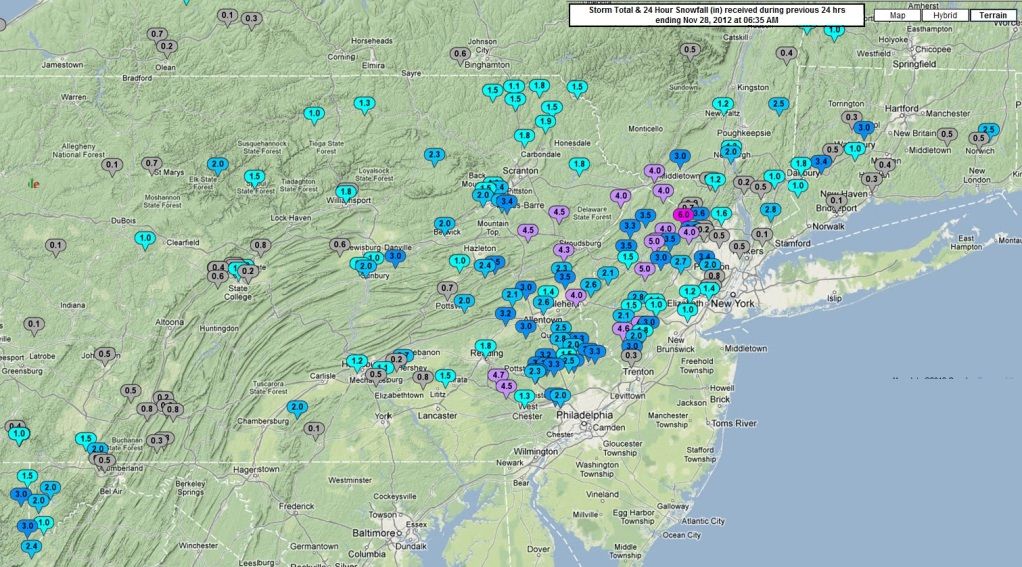
So far things going according to forecast. Light event, most of the higher snow accumulations staying over WV, PA and parts of NJ.

Highest total I seen was in Tucker WV with 5 inches but that is probably up higher elevation there. Generally T-3" event higher in areas mentioned above.

Black Ice is the threat tonight as temps crash. Precip not over for some yet. Still snowing in CT (not near the coast)

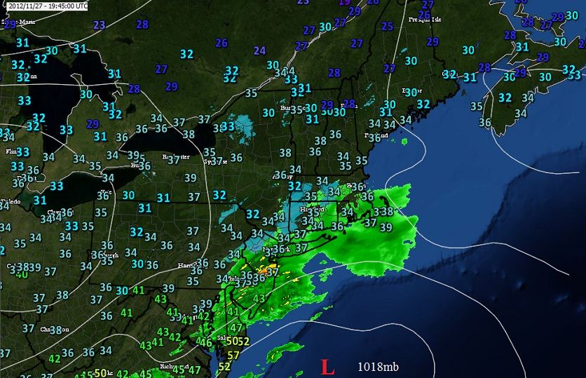
Quick look at the temps and radar as the storm exits.
Quick reply to this message
 
Old 11-27-2012, 03:21 PM
 
Location: Near the Coast SWCT
83,283 posts, read 74,503,009 times
Reputation: 16504
Some higher reports from the New Jersey NWS office which covers parts of PA.

Some areas with over 3 inches of snow.

...HUNTERDON COUNTY...
WHITEHOUSE 2.8

...MORRIS COUNTY...
BUTLER 4
ROCKAWAY3.5
RANDOLPH 3.0

...SUSSEX COUNTY...
WANTAGE 4
LAFAYETTE 3.5
FREDON 3.3

...WARREN COUNTY...
ALLAMUCHY 3.5
STEWARTSVILLE 2.6
PENNSYLVANIA

...BUCKS COUNTY...
DOYLESTOWN 3.6
FURLONG 3.3
DUBLIN 3.3

...CARBON COUNTY...
ALBRIGHTSVILLE 4.5
SUMMIT HILL 3.5

...CHESTER COUNTY...
ELVERSON 4.7
GLENMOORE 4.5

...DELAWARE COUNTY...
WAYNE 3.5

...LEHIGH COUNTY...
ALLENTOWN 2.6

...MONROE COUNTY...
SAYLORSBURG 4.3

...MONTGOMERY COUNTY...
GRATERFORD 3.3
SKIPPACK 3.3
SPRING MOUNT 3.2
ROYERSFORD 3
LIMERICK 3

...NORTHAMPTON COUNTY...
NAZARETH 3.5

...PHILADELPHIA COUNTY...
PHILADELPHIA INTL T

http://forecast.weather.gov/product....n=1&glossary=0
Quick reply to this message
 
Old 11-27-2012, 04:48 PM
 
Location: Near the Coast SWCT
83,283 posts, read 74,503,009 times
Reputation: 16504
Half a foot of snow fell in parts of NJ.

Lake Hopatcong, NJ in Morris County with 5" but West Milford, NJ in Passaic county with 6"
PNS from KOKX

Thats where the heavy bands set up with this one. Nice..
Quick reply to this message
 
Old 11-27-2012, 05:04 PM
 
Location: Near the Coast SWCT
83,283 posts, read 74,503,009 times
Reputation: 16504
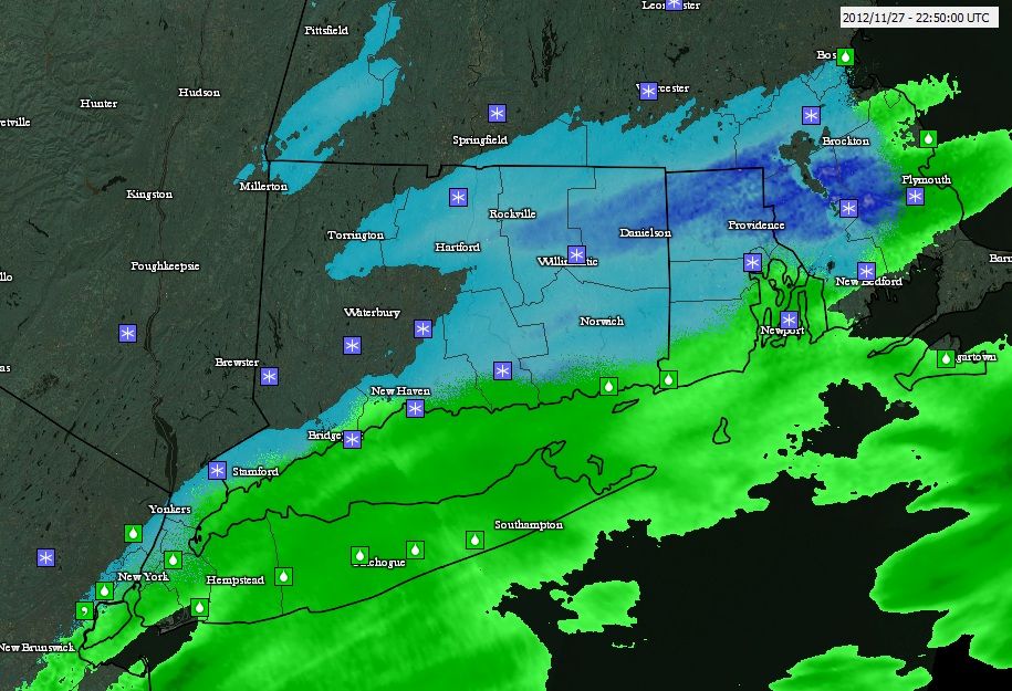
As the storm moves away and strengthens a little its throwing down a little heavier precip. Notice the heavier steadier band of snow Northern Rhode Island heading towards Plymouth MA right now. They could get a quick burst of accumulating snow.

Also note.... the joys of coastal living. This event was a typical coastal CT event.

Rain at the coast, snow interior .

Quick reply to this message
 
Old 11-27-2012, 05:28 PM
 
Location: Mid Atlantic USA
12,623 posts, read 13,845,295 times
Reputation: 5883
Quote:
Originally Posted by Cambium View Post
Some higher reports from the New Jersey NWS office which covers parts of PA.

Some areas with over 3 inches of snow.

...HUNTERDON COUNTY...
WHITEHOUSE 2.8

...MORRIS COUNTY...
BUTLER 4
ROCKAWAY3.5
RANDOLPH 3.0

...SUSSEX COUNTY...
WANTAGE 4
LAFAYETTE 3.5
FREDON 3.3

...WARREN COUNTY...
ALLAMUCHY 3.5
STEWARTSVILLE 2.6
PENNSYLVANIA

...BUCKS COUNTY...
DOYLESTOWN 3.6
FURLONG 3.3
DUBLIN 3.3

...CARBON COUNTY...
ALBRIGHTSVILLE 4.5
SUMMIT HILL 3.5

...CHESTER COUNTY...
ELVERSON 4.7
GLENMOORE 4.5

...DELAWARE COUNTY...
WAYNE 3.5

...LEHIGH COUNTY...
ALLENTOWN 2.6

...MONROE COUNTY...
SAYLORSBURG 4.3

...MONTGOMERY COUNTY...
GRATERFORD 3.3
SKIPPACK 3.3
SPRING MOUNT 3.2
ROYERSFORD 3
LIMERICK 3

...NORTHAMPTON COUNTY...
NAZARETH 3.5

...PHILADELPHIA COUNTY...
PHILADELPHIA INTL T

National Weather Service Text Product Display
All well north and west of the city. Nothing in southeast New Jersey across the river, and nothing in the inner burbs on the west side of the city. A real non event, and the snow will be gone on one to two days where it did accumulate.

No bid deal. 55f and sunny this weekend. Yeah!
Quick reply to this message
 
Old 11-28-2012, 06:17 AM
 
Location: Near the Coast SWCT
83,283 posts, read 74,503,009 times
Reputation: 16504
Default November 27, 2012 Snowfall Totals.

Few select higher totals from the storm. NJ was the jackpot zone. Widespread 3-5" in Northern NJ.. Map didnt have Rhode Island or Eastern MA so maybe I'll update it when it does.


CONNECTICUT
...FAIRFIELD COUNTY...
NEWTOWN 3.4
DANBURY 1.8

...NEW HAVEN COUNTY...
WOLCOTT 3.0

...NEW LONDON COUNTY...
LISBON 2.5

...TOLLAND COUNTY...
TOLLAND (1000') 3.5
COVENTRY (835') 3.5

...WINDHAM COUNTY...
WILLIMANTIC 3.0


NEW YORK
...WESTCHESTER COUNTY...
ARMONK 2.8


.ORANGE COUNTY...
GREENVILLE 4.0
MIDDLETOWN 3.0

MASSACHUSETTS
...PROVIDENCE COUNTY...
NORTH FOSTER 3.2
BURRILLVILLE 2.5
WEST GLOCESTER 2.1


PENNSYLVANIA
...CENTRE COUNTY...
STATE COLLEGE 1.0

NORTHUMBERLAND COUNTY...
8 E SUNBURY 3.0

NEW JERSEY
...MORRIS COUNTY...
CHESTER 5.0
LAKE HOPATCONG 5.0

...PASSAIC COUNTY...
WEST MILFORD 6.0

...ORANGE COUNTY...
GREENVILLE 4.0
MIDDLETOWN 3.0


(Map is missing a few)
Quick reply to this message
 
Old 11-28-2012, 06:20 AM
 
Location: Near the Coast SWCT
83,283 posts, read 74,503,009 times
Reputation: 16504
November 2012 was the first time ever since records began that Bridgeport, CT ever had 2 snow events with more than a trace in the month. They also broke the record with the last storm being it was the biggest November snowstorm on record (records go back to 1948)
Quick reply to this message
Please register to post and access all features of our very popular forum. It is free and quick. Over $68,000 in prizes has already been given out to active posters on our forum. Additional giveaways are planned.

Detailed information about all U.S. cities, counties, and zip codes on our site: City-data.com.


Please update this thread with any new information or opinions. This open thread is still read by thousands of people, so we encourage all additional points of view.

Quick Reply
Message:
Over $104,000 in prizes was already given out to active posters on our forum and additional giveaways are planned!

Go Back   City-Data Forum > General Forums > Weather
Similar Threads

All times are GMT -6.

© 2005-2024, Advameg, Inc. · Please obey Forum Rules · Terms of Use and Privacy Policy · Bug Bounty

City-Data.com - Contact Us - Archive 1, 2, 3, 4, 5, 6, 7, 8, 9, 10, 11, 12, 13, 14, 15, 16, 17, 18, 19, 20, 21, 22, 23, 24, 25, 26, 27, 28, 29, 30, 31, 32, 33, 34, 35, 36, 37 - Top