Please register to participate in our discussions with 2 million other members - it's free and quick! Some forums can only be seen by registered members. After you create your account, you'll be able to customize options and access all our 15,000 new posts/day with fewer ads.
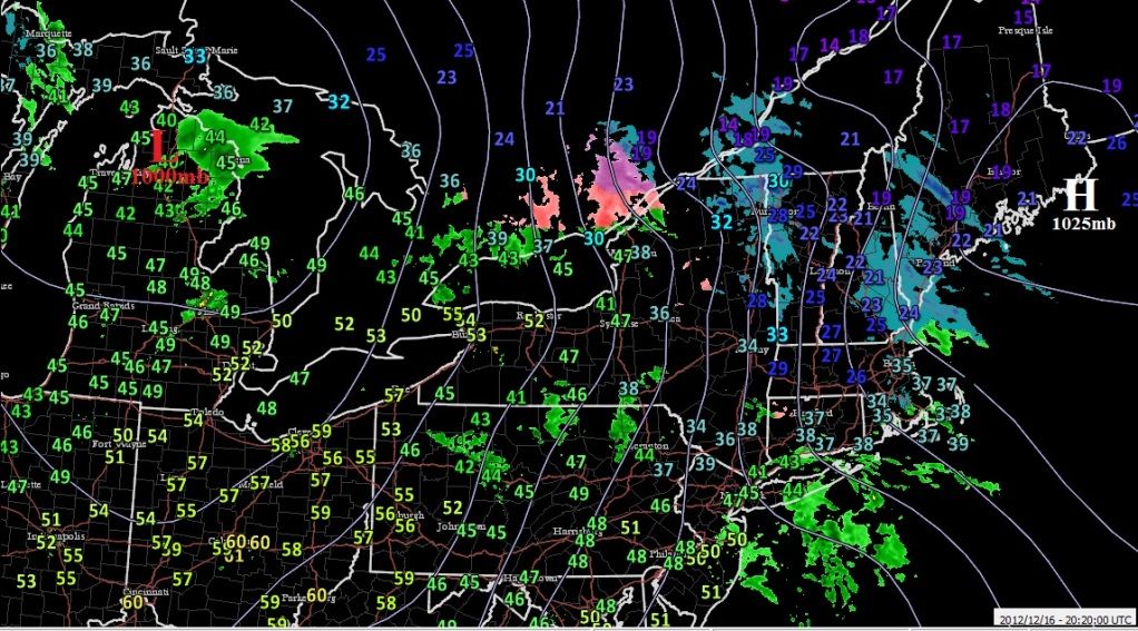
Check this out. I was wondering why the winds were picking up today gusting to 25mph.
High pressure now over Maine. .. Low Pressure over Great Lakes. Pressure gradient tightening. Also ... people in short sleeves in Mid Atlantic and Ohio Valley as far north as Buffalo, while people were freezing in New England. That high pressure kept the warm air from surging too far north.
lol. Interesting isnt it? Thats why winter weather is so interesting. I didnt get out of the 30s today in CT while you were in the 50s in NJ probably. More importantly what a High Pressure can do to control temps. and we have to figure out where the rain/snow line setsup.
Interesting to see the JMA and EUro ensembles close the low off further south for Friday. Maybe a south trend is in the works? I can see that happen if the blocking is not modeled correctly.
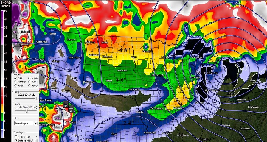
Fom the Latest GFS model. Snow total by Thursday evening
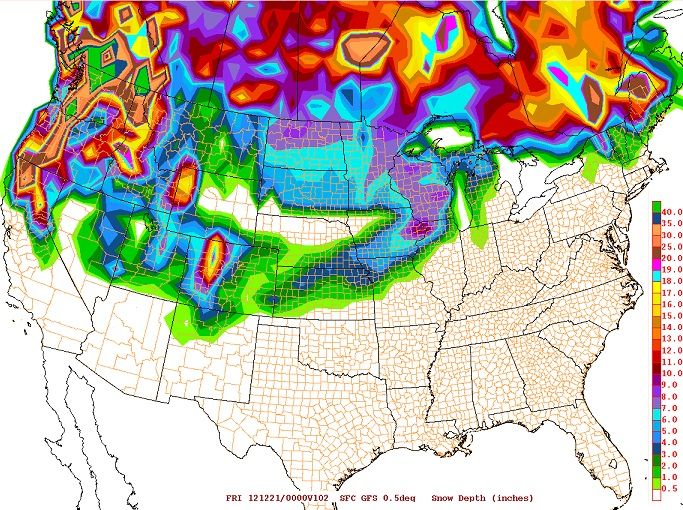
Hi there Cambium.... at work now. I see that was from the 12z GFS. What I dont get all that snow over North Dakota that run of the GFS and other runs too only have maybe an inch or two at best from a weak system Tue-Wed for us.... and nothing Thu. I wonder if the system you displaying with is showing bad snow amounts or what.... I wish we could get that much snow..... not much snow so far locally in eastern ND.....we still have our 1 inch on the ground. With our cool weather that will not go away until March.
The 18z GFS just came in and curious what you see from your display on total snowfall thru 00z Fri Dec 21 versus the attached image which is the raw model output on GFS total snow thru 00z Fri.
Hey, thanks for the post. Hard to see the graphic and legend there. Keep in mind my post was "snow depth" up until that hour on that run.
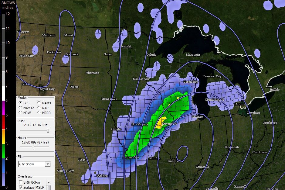
Using the same hour you posted (102)thursday 7pm here's how the snow depth looks on the 18z GFS.... But take a look at the 6hr snowfall for hr87 below which better reflects the storm itself. Given the track of the storm ND seems to far out to benefit from this one so thanks for the heads up and reminder for all..
Oh ok....yeah the snow depth one isnt all that valuable....I dont know where it has the 6-8 in eastern ND thru nrn MN....we got around 1-2 inches presently except right along the border and if we get an inch (which is generous) still off a bit. So advise to use with caution.
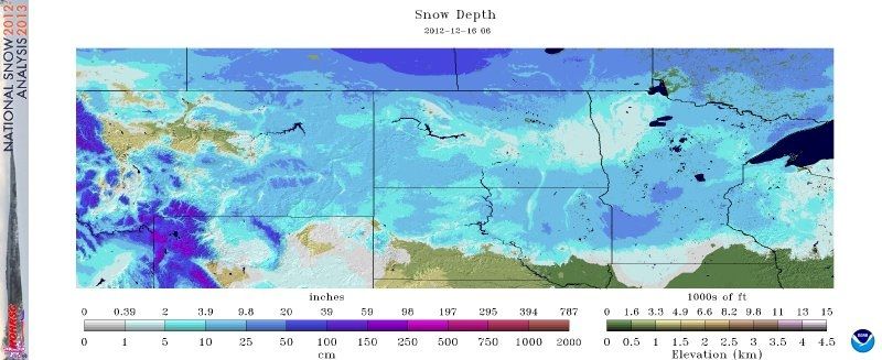
After I posted I did see SnowD in the upper left.
That was an AWIPS screen capture.... we dont have any fancy computer PC programs to pull AWIPS images into the PC....that is the best we have.
Oh ok....yeah the snow depth one isnt all that valuable....I dont know where it has the 6-8 in eastern ND thru nrn MN....we got around 1-2 inches presently except right along the border and if we get an inch (which is generous) still off a bit. So advise to use with caution.
After I posted I did see SnowD in the upper left.
That was an AWIPS screen capture.... we dont have any fancy computer PC programs to pull AWIPS images into the PC....that is the best we have.
Dan
Dan, I will find out what Mike Gibson says regarding how the model calculates it. For now it looks like there is more than 4" across parts of northern and southern N. Dakota, so the image I posted is not that far off considering there's already a few inches down. But I'm curious as well.
Is that a clipper coming down GFS is showing on Tuesday? It adds a few inches from that as well.
That was an AWIPS screen capture.... we dont have any fancy computer PC programs to pull AWIPS images into the PC....that is the best we have.
Dan
Here's from RalieghWx (Alan Hoffman) showing similar. 18z GFS Images
Please register to post and access all features of our very popular forum. It is free and quick. Over $68,000 in prizes has already been given out to active posters on our forum. Additional giveaways are planned.
Detailed information about all U.S. cities, counties, and zip codes on our site: City-data.com.

 Please register to participate in our discussions with 2 million other members - it's free and quick! Some forums can only be seen by registered members. After you create your account, you'll be able to customize options and access all our 15,000 new posts/day with fewer ads.