Please register to participate in our discussions with 2 million other members - it's free and quick! Some forums can only be seen by registered members. After you create your account, you'll be able to customize options and access all our 15,000 new posts/day with fewer ads.
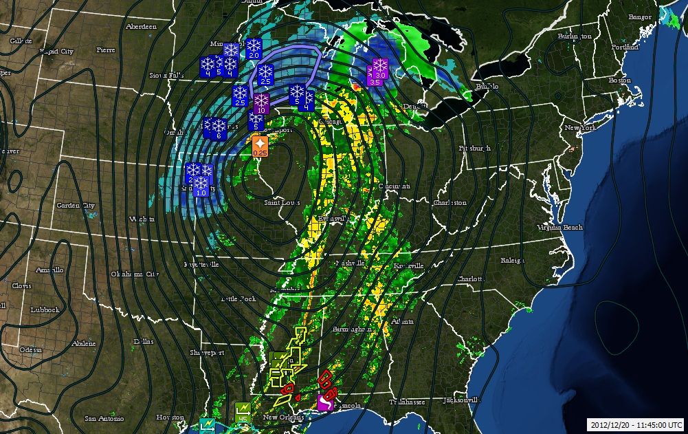
Wow. The push and the spin has started. Tornado warnings and a Funnel spotted down south. T-Storm warnings as well (6:30amEST December 20th). Blizzard warnings to the north with hail reports right before the rain/snow line. Squall line formed and heading east.
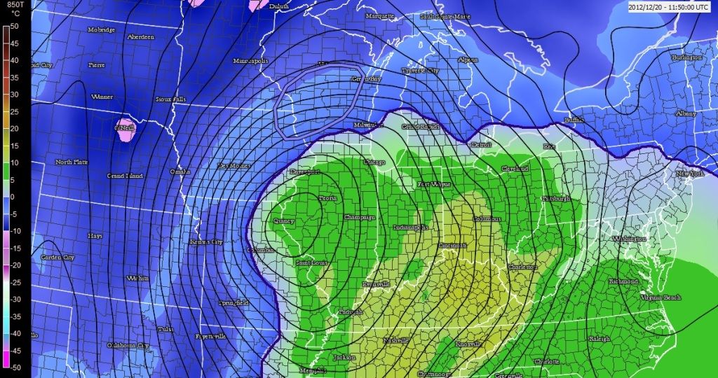
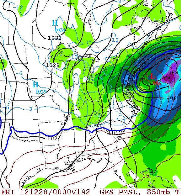
Closeup of the 850mb temps without radar. I outlined the freezing mark. If the 5000' level is not below freezing, there's basically no chance for snow. This system is starting to wrap around the cold air and making its own.
Woke up to no snow, just rain, but I am only blocks from Lake Michigan. There are areas that have 7 inches of snow already but hasn't happened here. I wonder if we will get much lower amounts than those predicted. It falls in line with the special weather statement GB issued yesterday.
Woke up to no snow, just rain, but I am only blocks from Lake Michigan. There are areas that have 7 inches of snow already but hasn't happened here. I wonder if we will get much lower amounts than those predicted. It falls in line with the special weather statement GB issued yesterday.
Since the center of the storm is heading right for you I dont expect a changeover today. I'm thinking after 5pm. Let us know. but yeah, that will keep totals less than others to your north and west.
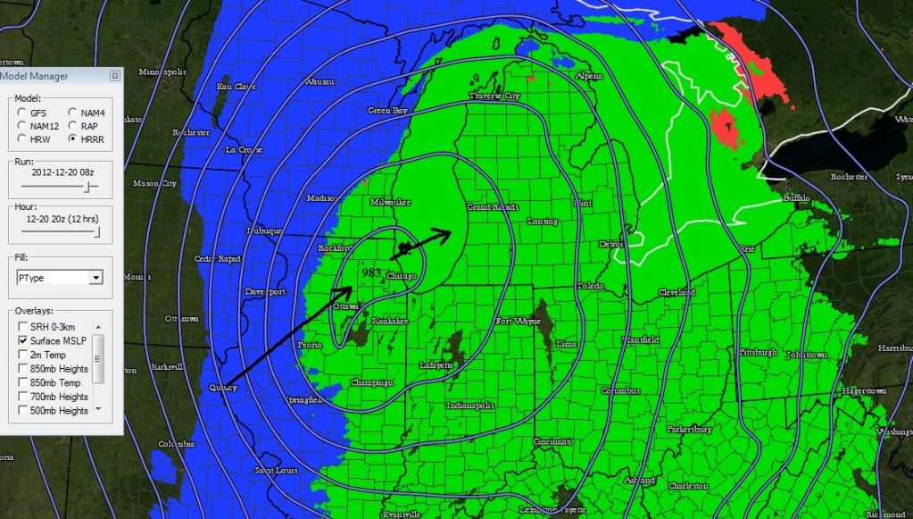
Here's where the rain/snow line is as the center of the storm is around Chicago. 2pm CST
Impossible to mention all the reports from this storm so far... Over a foot in many areas. 3 foot drifts. Blinding snow. Thunder snow. Power outages. Sheds blown away down south from squall line and tornadoes. 50+mph winds. Hail.
I12/20/2012, 4.3 INCH , DANE, WI
MODERATE SNOW AT TIME OF OBSERVATION. THUNDER AND LIGHTNING FROM 1230 AM TO 1255 AM. 4.3 INCHES IN 2 HOURS.
12/20/2012, 8.1 INCH, ADAMS, NE OFFICIAL NWS OBS
OFFICIAL STORM TOTAL SNOWFALL AT NWS OFFICE...MELTED DOWN TO 1.03 INCHES OF LIQUID EQUIVALENT
12/19/2012 , PHELPS, NE EMERGENCY MNGR
MANY STRANDED MOTORISTS IN PHELPS COUNTY. SHELTER OPERATIONS BEING REQUESTED FROM RED CROSS.
12/19/2012 , CLAY, NE LAW ENFORCEMENT
WHITE-OUT CONDITIONS. VISIBILITY IS ZERO. POLICE CANNOT EVEN SEE HEADLIGHTS RIGHT IN FRONT OF THEM DUE TO BLOWING SNOW.
We are only expecting a couple inches in N Indiana away from the lake. Also, it is so mild, I expect more to accumulate on the grassy areas than the streets.
Thanks, great model! It is still just above freezing here, I would rather have snow. All this heavy rain, then freezing if temps drop, not a good thing.
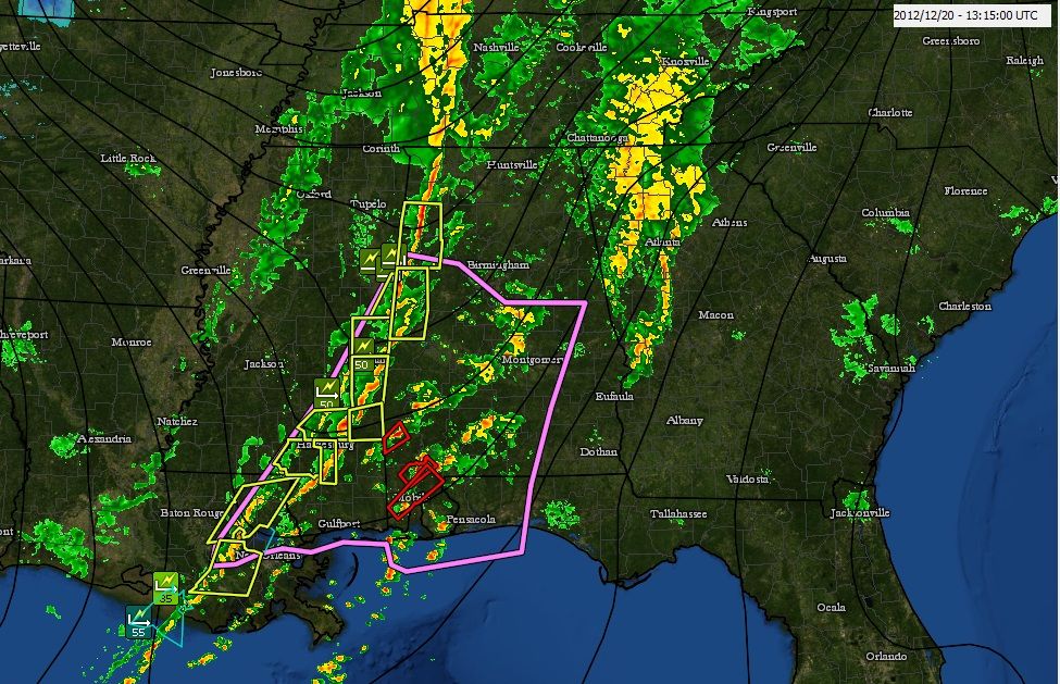
Closeup of the south. they are waking up to loud boomers, heavy downpours. Severe Thunderstorm warnings along the squall line and Tornado warning ahead of it. There's robably sirrens going on in some spots right now.
Good morning from central WI. Woke up to 24F and about 6" of snow so far. The snowplows are out in force and all schools closed around here. Local News saying, "There is a layer of ice under the snow" and "Do not drive anywhere unless you absolutely have to!"
It appears to be a lighter fluffier snow than they had forecast... it's not sticking to the trees like in the last snowstorm we had here on Dec. 8th/9th.
Not to take away from the current storm but we'll have another big snowstorm this month to follow. Latest models have it targeting the East Coast now. 27th
Please register to post and access all features of our very popular forum. It is free and quick. Over $68,000 in prizes has already been given out to active posters on our forum. Additional giveaways are planned.
Detailed information about all U.S. cities, counties, and zip codes on our site: City-data.com.

 Please register to participate in our discussions with 2 million other members - it's free and quick! Some forums can only be seen by registered members. After you create your account, you'll be able to customize options and access all our 15,000 new posts/day with fewer ads.