Please register to participate in our discussions with 2 million other members - it's free and quick! Some forums can only be seen by registered members. After you create your account, you'll be able to customize options and access all our 15,000 new posts/day with fewer ads.
Latest models today shifted west. Rain for the coast and in the lastest GFS case, rain for most.
Case in point about this area being crappy in the winter where a perfected track has to happen. It keeps things interesting but frustrating on the same token. I wish it would just be cold enough where any track would be snow.
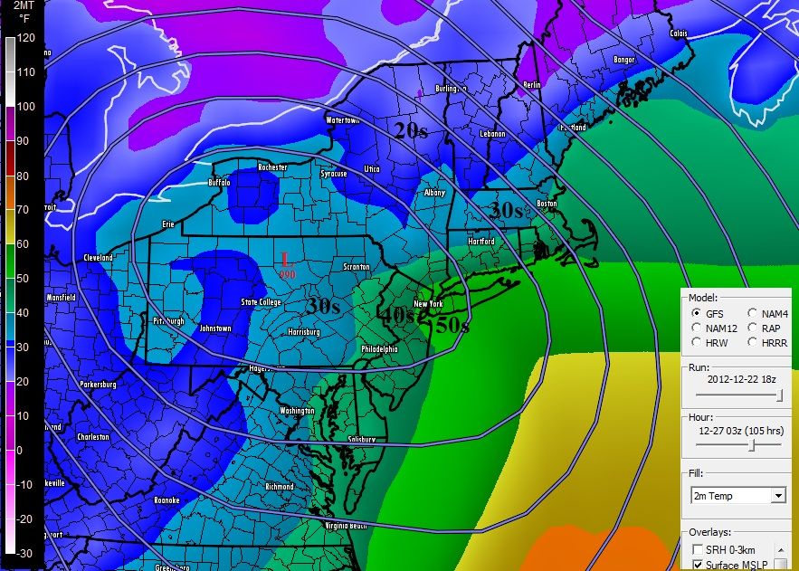
Latest GFS has mid 50s for NYC Thursday evening when the Low is over PA... (note its not a NorEaster )
GOOD POSSIBILITY THAT NORTHEAST ARKANSAS AND NORTHWEST TENNEESEE MAY SEE SIGNIFICANT
SNOWFALL AMOUNTS WITH CHANGE OVER CLOSER TO SUNSET FOR ALL SNOW...MEMPHIS AREA BEFORE MIDNIGHT WITH SOME DECENT SNOWFALL POSSIBLE WITH THE RIGHT TRACK OF THE STORM
Sunset? If there's to be any changeover, sunset changeovers can be kind of cool. Anyway, as long as we're on the subject of the South, I'm more interested in Oklahoma's part of the storm than Tennessee's. TWC thinks it's now likely that parts of Oklahoma will get a White Christmas. NWS Tulsa thinks that the heavy snowband will drop 2-5 inches along a Fayetteville, AR to Hugo, OK line on Christmas morning. Talk about good timing. Here's the Special Weather Statement from NWS Tulsa:
Quote:
...WINTER STORM REMAINS ON TRACK TO IMPACT PORTIONS OF EASTERN OKLAHOMA AND NORTHWEST ARKANSAS CHRISTMAS DAY/NIGHT...
A WINTER STORM WILL DEVELOP OVER THE SOUTHERN PLAINS CHRISTMAS DAY WITH THE LIKELY-HOOD OF ACCUMULATING SNOW ACROSS PORTIONS OF EASTERN OKLAHOMA AND NORTHWESTERN ARKANSAS. ALTHOUGH THE EXACT TRACK REMAINS SOMEWHAT UNCERTAIN...MOST OF THE REGION WILL LIKELY RECEIVE AT LEAST AN INCH OR TWO OF SNOW FROM THIS SYSTEM. THE STORM WILL LIKELY LAY DOWN A HEAVIER BAND OF SNOW ACROSS PORTIONS OF THE REGION. LATEST DATA SUGGEST THE GREATEST SNOW POTENTIAL WILL OCCUR ALONG AND SOUTH OF A EUFAULA TO EUREKA SPRINGS LINE WITH 2 TO 5 INCHES OF SNOW LIKELY WITH LOCALLY HEAVIER AMOUNTS POSSIBLE. PERSONS TRAVELING ACROSS THE REGION CHRISTMAS DAY INTO CHRISTMAS NIGHT SHOULD CONTINUE TO CLOSELY MONITOR THE LATEST FORECAST.
WE ARE CURRENTLY POSTING PRELIMINARY SNOW AMOUNTS TO OUR DECISION SUPPORT PAGE AT Hazardous Weather Decision Support, NWS Tulsa, OK. THE LOCATION AND MAGNITUDE OF THE WINTER WEATHER IMPACTS WILL CONTINUE TO BE REFINED AS THIS SYSTEM APPROACHES. SNOW AMOUNTS WILL CONTINUE TO BE ADJUSTED AND THE LOCATION OF THE HEAVIEST SNOW SWATH COULD SHIFT SEVERAL COUNTIES IN ANY DIRECTION. PERSONS ACROSS SOUTHEAST OKLAHOMA AND NORTHWEST ARKANSAS SHOULD BE PREPARED FOR SIGNIFICANT ACCUMULATING SNOW CHRISTMAS DAY INTO CHRISTMAS NIGHT. ROADS WILL LIKELY BECOME SLICK AND HAZARDOUS IN SOME AREAS CAUSING TRAVEL DELAYS. A WINTER STORM WATCH AND SUBSEQUENT WINTER STORM WARNING WILL LIKELY BE REQUIRED FOR PORTIONS OF THE AREA INTO CHRISTMAS DAY.
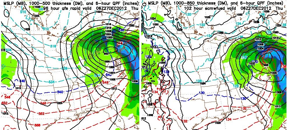
Overnight, both models stand ground. Just look at this!!
Check out the GFS on the left where the center of the storm is and Euro on the right. So different being one is over land and one goes just off the coast!
Hmmm, weather channel this a.m. is going with the GFS in the maps where they show who is getting snow late week. It will be interesting to see how it finally shapes up. Our local station isn't predicting major amounts of snow for Thursday.
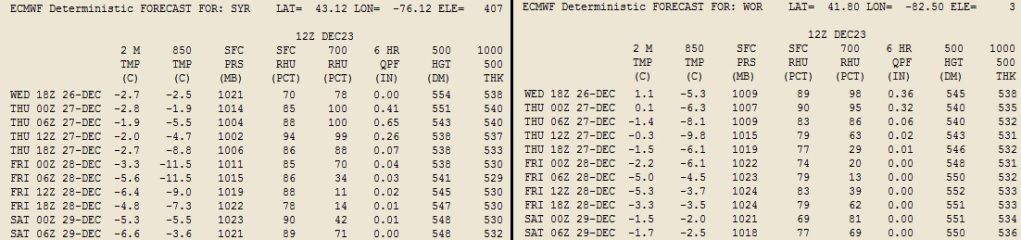
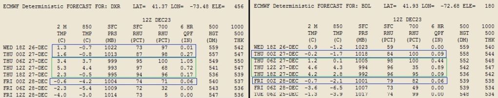
For those interested..Here's the data output from the latest 12zEuro..
You can see what the surface temps are like (2M temps) and how much rain or snow liquid there is.(6hr qpf).. also see the 850 temps which needs to be negative for snow.
Syracuse,NY on left, Worchester, MA on right.
Over 1.25" qpf of all snow for Syracuse. Looks like better than 12:1 ratios as well. Over a foot.
Danbury,CT on left, Windsor Locks,CT on Right.
Looks like it starts as snow and turns to very heavy rains for both locations then back to light snow.
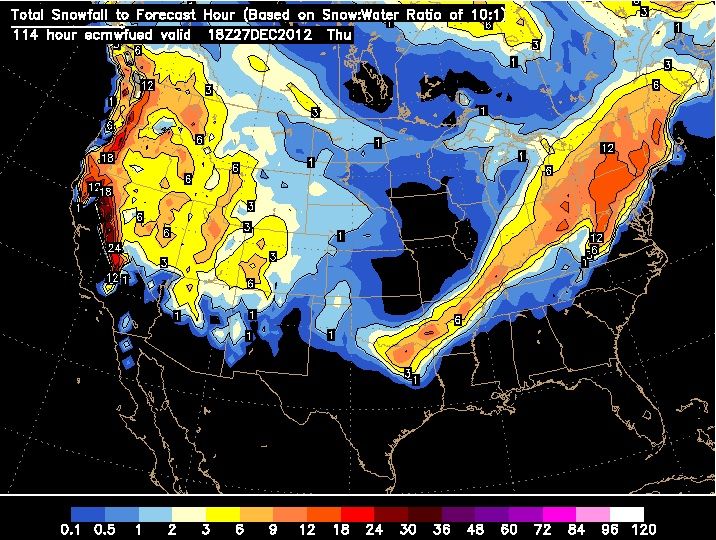
Here's the Euro12z snowfall total. It's absolutely continuing its consistancy of showing a large swath of 12"+. In fact this run is showing a 6-8" snowfall within 6hr time from Northeast PA and central NY Wednesday night.
This storm is going to lay down a thicker snowpack which will further help the air at the surface stay cooler. Some will get snow, some won't. Thats how it always is.
NWS Memphis created a predicted snowfall total map for the area. As of right now, they are predicting 1.7 inches for Memphis, but up to 7 inches in the Northwestern counties. Though this will probably change.
Please register to post and access all features of our very popular forum. It is free and quick. Over $68,000 in prizes has already been given out to active posters on our forum. Additional giveaways are planned.
Detailed information about all U.S. cities, counties, and zip codes on our site: City-data.com.

 Please register to participate in our discussions with 2 million other members - it's free and quick! Some forums can only be seen by registered members. After you create your account, you'll be able to customize options and access all our 15,000 new posts/day with fewer ads.


 )
)

 Looks like better than 12:1 ratios as well. Over a foot.