Please register to participate in our discussions with 2 million other members - it's free and quick! Some forums can only be seen by registered members. After you create your account, you'll be able to customize options and access all our 15,000 new posts/day with fewer ads.
In this thread you can describe the geography of your many fictional / made up climates so we can get a bigger insight of your fictional climates scenery.
Questions to be answered
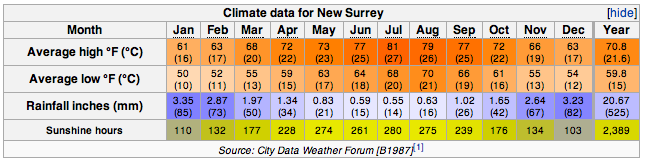
Is your fictional climate a city? Yes, a medium-sized city with around 4-5 million people.
Does a mountain range overlook your fictional climate's location? There is an extinct volcano on the west coast, around 70 km from the city on the east coast.
How far is it from the coast? It is on the coast
Whats the elevation? 0-200 metres (the volcano is around 2000 metres but outside the city limits).
Is it located in a valley or on top of a large plateau? A large plateau cut by 2 rivers, with sparse hills/cliffs by the coast.
What biome is your fictional climate located in? Mediterranean scrubland.
New Surrey is on a small island around 200 miles WSW of Gibraltar.
It is a city, functioning as the hub of the deep interior. I imagine that it's of a similar size to Anchorage, perhaps a bit bigger, with a population in the neighborhood of 200 000 to 800 000 for the entire metro area.
Patricianopolis is quite isolated from other cities, with the nearest major city being hundreds of miles away. However, the distance is mitigated by ultra-high speed rail and freeway links, which provide easy travel to the other distant cities. These links function mostly in summer; when the snowpack reaches 10 feet snowmobiles and snow coaches become the sole form of motorized transport. These are quite efficient in Patricianopolis, but are slower than the other methods.
The actual topography of the area is flatland, but mountains are in the background, associated with the High Country range to the northeast. I figure that it's roughly 1200 miles from the actual ocean, and at least 500 miles from the nearest major sea. The biome is a drier boreal forest, with forest cover being dominant, but occasionally giving way to large clearings. There are many small lakes in the region, with the nearest one being 10 miles from the city center.
Patricianopolis has rather cool summers for a place so far away from major bodies of water. I always pictured you liking more maritime climates such as those found in western Alaska, for example.
Patricianopolis has rather cool summers for a place so far away from major bodies of water. I always pictured you liking more maritime climates such as those found in western Alaska, for example.
I happen to like the interior, though I'm not averse to the coast, either. The summers are rather cool for an interior location, but since some interior locations in Canada come close to Patricianopolis's temperature profile, I think it would only take minor tweaking of orbits and axes and a different upper-level pattern to create a climate like that in the interior on a real planet's continent.
Also keep in mind that this is a fiction - it doesn't have to be realistic. But also keep in mind that even realistic climates can be very different from Earth's.
Is your fictional climate a city?
Dolbury has a population roughly around 6 million.
Does a mountain range overlook your fictional climate's location?
There are no true mountains but the inland suburbs are very hilly around 100 metres above sea level. The areas to the south and west of the city is in the black hills region known for its lush temperate forests.
How far is it from the coast?
The city's downtown area is located along the coast.
Whats the elevation?
Varies considerable from 0 metres (at sea level) to just over 100 metres in the suburbs.
Is it located in a valley or on top of a large plateau?
The bulk of the city is located in a coastal plain however inland areas are very hilly
What biome is your fictional climate located in?
Temperate broadleaf forests
Geographic facts about Lonington
Is your fictional climate a city?
Its a large mega city with a population of around 12 million so there's a significant urban heat island effect.
Does a mountain range overlook your fictional climate's location?
No
How far is it from the coast?
Its roughly 400 miles from a large lake to its west which produce heavy lake effect snow for the city throughout the winter months. The lake also produces lower sunshine hours.
Whats the elevation?
The elevation of the city is around 30 metres in the city centre (downtown) to just over 89 metres in the northwestern suburbs.
The city is located in a valley of a long river. Some parts of the metropolis is located within a frost hollow.
What biome is your fictional climate located in?
Already answered on a previous post - Temperate broadleaf/boreal forest transition
In this thread you can describe the geography of your many fictional / made up climates so we can get a bigger insight of your fictional climates scenery.
Questions to be answered
Is your fictional climate a city?
Does a mountain range overlook your fictional climate's location?
How far is it from the coast?
Whats the elevation?
Is it located in a valley or on top of a large plateau?
What biome is your fictional climate located in?
Good idea! Been actually thinking a bit about it. (Except for the name, should really rename it.)
Answers:
Yes, it's the capital of a fictional country in Europe, probably an island nation. The city, founded in the 6th century AD, has 1.5 million inhabitants, and the urban area around 3 million. (Size of Lisbon). They use the metric system and drive on the right. The time zone is CET (UTC +1).
The City of False Light is located on the coast by a river, but the city is mostly on the western bank, and the port and industry is on the eastern side. The elevation ranges from 7 meters in the historical city centre up to 80 meters in the suburbs.
On a larger scale, the city is on the southeastern plain of the country, called the central plain. A mountain range some 250 km in the west affect the climate. The central plain is the most continental area of the country, but as the city is located on the coast, the maritime influence is of course pronounced. It's not unheard of that precipitation sometimes comes as rain in the downtown and as snow in the suburbs.
Go 50 km inland, and you'll find a more reliable snowpack, chillier autumns and warmer max temperatures in spring. Due to the urban heat effect, temperatures in summer aren't really higher in the countryside.
The southeastern plain is mostly farmland, central European deciduous forest and soft rolling hills.
In the north of the country the climate resembles something of Southern England, while in the far south it's more like as on the Crimean peninsula. In the mountains there are of course ski resorts, and on the windward side of the mountains you'll find a narrow strip of temperate rainforest.
1. Yes. Population 50,000
2. It is in the mountains
3. Around 400 miles from the ocean
4. 6500 feet.
5. In a valley.
6. Mountain forest biome.
Additional info: There is a lake nearby, which can produce large snowfalls. Latitude is 45 N in a region similar to the Pacific Northwest, but the Rocky Mountains are much lower than they are now, which allow more Arctic air through than they do presently making conditions colder, but more stable. Most precipitation is orographic and the lower elevations are semi-arid to desert. The valley is surrounded by mountains up to 13,000 feet in elevation and can recieve up to 500 inches of snow per year. Skiing is a popular activity, and it is possible from October to July.
1- yes, 5,125,905 people strong in the metropolitan area. The average low in February is -19 F / -29 C in the city proper due to the UHI; average nighttime lows in most suburbs in February are about -25 F / -32 C. Average high in the city in August is 91 F / 33 C - it's closer to 89 F / 32 C in the suburbs.
2- yes, some suburbs are built onto the foothills and even in the mountains, others are 15-20 miles (24-32 kilometers) east of the mountains, with most being between; Helmintoller's weather station is 9 miles (15 kilometers) east of the nearest mountain base
3- 1,190 miles (1,915 kilometers), to the east-southeast (closest point). The Helmintoller River runs through the area though. It's about the size of the Mississippi River in width.
4- 1,121 feet (342 meters) - ranges from 825 feet to 12,995 feet in suburbs, most under 1,300 feet
5- yes, in a valley about 100 miles (160 kilometers) wide, running southeast to northwest
6- extreme humid continental. Broadleaf forests out the wazoo.
1. My dream climate is a little village with approximately 1000 inhabitants...
2. It is situated on the northwestern side of a continent with a ~2000 meters mountain range to the east.. Nevertheless that mountain range doesn't have a big "density" meaning there is plenty of space left between the single mountains (not your narrow-valley type of mountains)... All in all the town is actually more or less situated in the mountains, but since it's
3. only ~20 km away from the sea, there are not too many mountains surrounding it to the west. The warm sea to the northwest produces severe lake effect snowfalls in winter, since bitterly cold air masses are frequently coming in from the north, where in another continent is situated...
4. The elevation is ~500m ...
5. it's actually neither a real valley nor a plateau... It's more like a bigger flat area between several mountains surrounding it.
6. Taiga with some species of deciduous trees
there is always a light breeze coming from the ocean, which can turn into severe storms in fall and winter, although the humidity is surprisingly low for a place with such a maritime influence.. nonetheless, cloudiness is really high in all seasons... I haven't decided yet, at which exact latitude the place is situated, but it's definetely something between 60 and 67° north.
1) It has about 100,000 people with many amenities. It is about 60 miles east of the "big city" which is on the coast and has about 700,000 people.
2) Yes, mountains to the west separate the city from the ocean and reach to about 7,000 feet, blocking some of the oceans moderating effects. To the east is an even larger mountain range with mountains peaking out at 12,000 feet.
3) Its about 65 miles from the ocean. There is a river that goes through the westerly mountains and through the city, ending at a high elevation lake.
4) Elevation of downtown is 2,000 feet, with surrounding suburbs reaching higher.
5) It is located in a valley between the two mountain ranges.
6) The trees are similar to those in Oregon; pine trees. It stays green almost all year round because of the adequate rainfall in all months (though winter has significantly higher rainfall.)
Please register to post and access all features of our very popular forum. It is free and quick. Over $68,000 in prizes has already been given out to active posters on our forum. Additional giveaways are planned.
Detailed information about all U.S. cities, counties, and zip codes on our site: City-data.com.

 Please register to participate in our discussions with 2 million other members - it's free and quick! Some forums can only be seen by registered members. After you create your account, you'll be able to customize options and access all our 15,000 new posts/day with fewer ads.


")
 The time zone is CET (UTC +1).

