Please register to participate in our discussions with 2 million other members - it's free and quick! Some forums can only be seen by registered members. After you create your account, you'll be able to customize options and access all our 15,000 new posts/day with fewer ads.
Interesting to see that whatever is happening on the eastern two thirds of the USA the western third is getting the opposite.
I always find that fascinating too. Its rare to see a trough so wide it engulfs the entire lower 48. Thats why a Ridge and Trough are common within at same time.
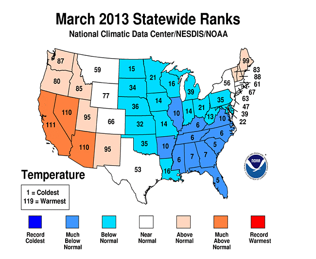
Here's another look at March using State Rankings. Usually Florida sticks out like a sore red thumb. This time its Maine. lol
In Tennessee, I don't remember March 2002 being all that cold, but March 2013 was frigid. Only the West saved this March from being the coldest in an even longer span of time.
Rarely see Canadien data so thanks! I'm sure some are confused on the red dots above normal in Eastern Canada while Eastern U.S was cold. Classic blocking pattern. Cold air dips down at an angle underneath the blocking from Western Canada to Eastern U.S.
Hence why Maine was above normal in March. Northern New England was the bottom border of that block. Had the blocking been just 150 miles north more than VT, NH, ME would have felt the cold and Florida would have been warmer.
Status:
"Apparently the worst poster on CD"
(set 27 days ago)
27,646 posts, read 16,133,597 times
Reputation: 19065
this is how you get average..Not liking the cold side of the scale myself
Please register to post and access all features of our very popular forum. It is free and quick. Over $68,000 in prizes has already been given out to active posters on our forum. Additional giveaways are planned.
Detailed information about all U.S. cities, counties, and zip codes on our site: City-data.com.

 Please register to participate in our discussions with 2 million other members - it's free and quick! Some forums can only be seen by registered members. After you create your account, you'll be able to customize options and access all our 15,000 new posts/day with fewer ads.