Please register to participate in our discussions with 2 million other members - it's free and quick! Some forums can only be seen by registered members. After you create your account, you'll be able to customize options and access all our 15,000 new posts/day with fewer ads.
Good point with snow melting in the rivers. Also Haven't checked the models lately of there's any rain coming.
Last one and I need a break till tomorrow. Ratios should be ranging from 6:1 to 15:1.
I don't think there is higher than that, except in the very higher elevations of 9,000+ feet. That's where the fluffy stuff is. Can you imagine a 25:1 ratio with 2" of liquid??
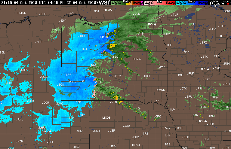
850 temps only in the low single digits below freezing but notice something... its not cold around the "surface" low pressure... It's cold around the upper low.
So you have warm juicy air feeding right into the cold air. The upper low is now about to go on top of the surface low (vertically stacked). The cold air will erode after time and as the storm moves it will weaken anyway.. But the radar is getting amazing. Another 18hrs should be done.
Absolutely incredible situation. Maybe unheard of for this early in the season if not ever in the Plains....
*Lead, South Dakota's snow tally is up to 37" and the blizzard rages on....
Sprearfish South Dakota
A freaking 100cm of snow in early October at LOW elevations. WTF!
GFS 18z additional snowfall +24 hours through Saturday midday 39'' -- assuming 10:1 liq-snow ratio
Tornado warning and super cells near Sioux City Iowa
I really don't know where to look anymore. 70mph wind gust with snow falling and on the ground or in the direction of the mile wide deadly Tornadoes on ground. Just sick.
60-70mph winds, feet of snow on the ground and still falling, leaves on trees, I'm going to guess it will be a while before we really see some updates from out there. Unprecedented stuff.
Blizzard warning extended into North Dakota, counties of Adams, Grant, & Sioux
Quote:
654 AM CDT SAT OCT 5 2013 /554 AM MDT SAT OCT 5 2013/
...BLIZZARD WARNING REMAINS IN EFFECT UNTIL 1 PM CDT /NOON MDT/
THIS AFTERNOON...
* TIMING...THROUGH THIS MORNING.
* HAZARDS...SNOW AND BLOWING SNOW REDUCING VISIBILITIES TO ONE
QUARTER MILE OR LESS.
* IMPACTS...POTENTIAL FOR DOWNED TREE LIMBS AND POWER LINES.
WHITEOUT CONDITIONS WILL MAKE TRAVEL EXTREMELY DANGEROUS.
These diverging streams of air delineate areas in the atmosphere in which air is ascending on a broad scale--the perfect breeding ground, when warmth, humidity and an impressive vertical decline in temps are present, for thunderstorms--and in tonight's set-up, super-cellular thunderstorms.
Quote:
The tornado outbreak has, in a near textbook fashion, occurred beneath diverging or "diffluent" branches of the jet stream. That this is the case can be seen on this Friday evening upper air analysis out of the Storm Prediction Center.The blue shaded areas on this map depict the region of the atmosphere reporting strongest winds at the 500 mb level (roughly 18,000 ft). You can see how one branch of the jet proceeds north/northwest into South Dakota while another veers off to the northeast into Iowa and Illinois.
These diverging streams of air delineate areas in the atmosphere in which air is ascending on a broad scale--the perfect breeding ground, when warmth, humidity and an impressive vertical decline in temps are present, for thunderstorms--and in tonight's set-up, super-cellular thunderstorms.
Please register to post and access all features of our very popular forum. It is free and quick. Over $68,000 in prizes has already been given out to active posters on our forum. Additional giveaways are planned.
Detailed information about all U.S. cities, counties, and zip codes on our site: City-data.com.

 Please register to participate in our discussions with 2 million other members - it's free and quick! Some forums can only be seen by registered members. After you create your account, you'll be able to customize options and access all our 15,000 new posts/day with fewer ads.