Please register to participate in our discussions with 2 million other members - it's free and quick! Some forums can only be seen by registered members. After you create your account, you'll be able to customize options and access all our 15,000 new posts/day with fewer ads.
Nice to see this being talked about. Typhoon re-curves, pumps the ridge up in the west, and in turn sends chilly air down East.
I remember saying "keep looking to the west & the Pacific" to see causes of the buckles of the Jet stream and the ridges and troughs. I even Forgot about the Typhoon re-curves.
NATIONAL WEATHER SERVICE STATE COLLEGE PA
1127 AM EDT FRI OCT 18 2013
.LONG TERM /SATURDAY NIGHT THROUGH THURSDAY/...
A SIGNIFICANT PATTERN CHANGE IS IN STORE FOR THE REGION DURING THE
EXTENDED PERIOD WITH MUCH OF THE EAST COAST COMING UNDER THE
INFLUENCE OF AN ANOMALOUSLY DEEP UPPER TROUGH THAT WILL MOVE OUR
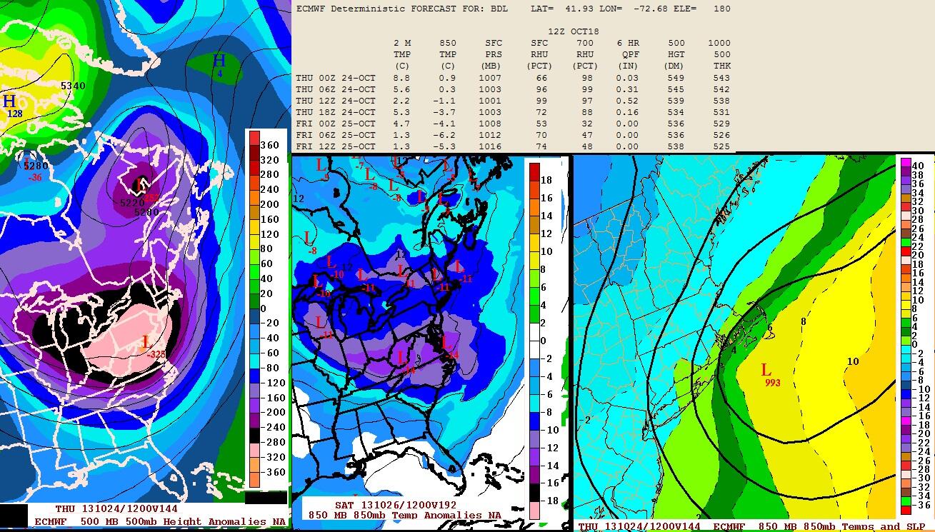
WAY OUT OF THE GR LAKES. A STRONG TYPHOON THAT PASSED EAST OF JAPAN SEVERAL DAYS AGO IS NOW BEING ABSORBED INTO THE FLOW OVER THE NORTHERN PACIFIC HELPING PUMP UP THE WESTERN NORTH AMERICAN RIDGE. THIS WILL HELP DELIVER INCREASINGLY CHILLY AIR DOWN INTO FIRST THE UPPER MID WEST AND EVENTUALLY INTO THE LOWER LAKES AND LOCAL AREA BY THE TUESDAY-WEDNESDAY TIMEFRAME.
PRECIP CHANCES WILL BE MANY...BUT MAINLY FROM MOISTURE-STARVED
CLIPPER TYPE SYSTEMS. TIMING WITH THESE ALWAYS PRESENTS A
PROBLEM...BUT WITH THE COLD AIR EXPECTED TO MOVE OUR WAY...ANY LIGHT SHOWERS THAT FALL DURING THE COLD PART OF THE DAY COULD ACTUALLY MIX WITH SOME WET SNOW. AN EARLY SEASON REMINDER OF WHAT IS IN STORE.
that's not true with the miami office. they like to sensationalise every extreame. back in 2011 the were calling for potentially all time record cold with sub freezeing temps all the way to miami beach. they even issued a hard freeze warning for interior miami-dade while the local chanel cbs station only predictied a freeze in the redlands with everyone else staying above freezeing. in the end guess who was right? the local forcasters of course and the NWS had to issue apoliegies 2 days in a row. At this point I take what they say with a grain of salt as they like to exagerate EVERYTHING!!.
That's true, I remember December 2010 they kept predicting freezes to the coast but only the far western suburbs got below freezing though it was a noteworthy cold snap, they overhyped that one to the max. I also notice how they understate summer temps down there (they'll predict a high of 87 F, and it'll end up being 92 F) they should know better 87 F is not going to be the high temperature ever under full sun in July in Miami.
Ugh. Next week looks awful. Why haven't there been more posts on all the weather we got?
Well the current weather has been pretty boring. Record warmth. Yawn. I personally find cold weather more interesting...especially since next week will likely be the coolest week since spring.
I did post about today being pleasant in the temperature thread though.
Yes so do I. We don't have any interesting weather here this year, all it wants to be is above average and wet. Its cloudy like every single day and the diurnal ranges are ridiculous. Sometimes it actually ends up being warmer at night which is stupid.
It would be nice to have some frosts and sunshine for once but that is not going to materialise. I can't personally see the fascination of warmth in the winter especially in a northern place like here where day-length is very short. To me sunshine and crispiness is far better than low cloud and warmth, I feel like that actually promotes colds and flus. I don't remember getting a single cold in 2010.
Please register to post and access all features of our very popular forum. It is free and quick. Over $68,000 in prizes has already been given out to active posters on our forum. Additional giveaways are planned.
Detailed information about all U.S. cities, counties, and zip codes on our site: City-data.com.

 Please register to participate in our discussions with 2 million other members - it's free and quick! Some forums can only be seen by registered members. After you create your account, you'll be able to customize options and access all our 15,000 new posts/day with fewer ads.


")