Please register to participate in our discussions with 2 million other members - it's free and quick! Some forums can only be seen by registered members. After you create your account, you'll be able to customize options and access all our 15,000 new posts/day with fewer ads.
Yes...all three are very similar in sun hrs Dec - Feb...and they are all close to the same latitude.
I did notice that the Vienna gets less than half the rainfall in the Dec - Feb that the two coastal stations.
I've been to Austria....and the first thing the traveler would note is the intense valley and Mt topography of the land. As you drive across Austria, you seem to drive into valleys, then you go through tunnels (LONG tunnels) which pass under Mts. Now I only saw the area closest to Salzburg...but perhaps the low sunshine hrs (relative to Brest/Vancouver) is another orographic situation; A station located in on the windward slopes of a open valley would no doubt see much more cloud/stratus and even precip than what would be typical of the climate. Also, Vienna lies within a transition between a oceanic and continential climate...so the lines would be more blurred I would think.Maybe a comparsion between stations in the Ukraine and northern France might show this better.
Still, I/m no expert on the patterns in Europe, but as a rule winter cloudness decrease eastward (or away from the ocean) in most Do/temperate oceanic climate sectors.
Vienna is located in the Danube plain. No big mountains or tunnels nearby contrary to Salzburg, only some big hills to the west. Budapest in Hungary far from the mountains in the same: Budapest - Wikipedia, the free encyclopedia
Cloudy spells aren't specifically associated with disturbed weather in winter in this part of the world. An anticyclone sitting over Europe with an unusually northern jet stream is the best way to get long strings of sunless days.
Jet stream over Iceland, 1020 hPa isobar over northern Scotland... Disturbed it is not. The correlation coefficient between sun hours and rainfall is 0.1 for the whole month, so even slightly positive, meaning that dry days were slightly duller than wet ones. Last August's was -0.3.
but I would tend to doubt that latitiude for latitude they would have less cloudy/stratus conditions that locations well inland from them.
Wow. And you think the main factor for cloudiness is the storm tracks. No matter the stats
What about high humidity, lack of wind and many other factors. Many of these completely cloudy days comes with high pressure system.
The reason is that these two regions are the centers cyclonic activity. While there are other "paths" that mid latitude storms follow in the cold season, these areas seem to have by far the highest number of disturbed weather events. This is esp true in the PNW areas of North American; In fact, using the average pressure fields in the northern Hemisphere...the Gulf of Alaska (just to the NW of the PNW) is the stormiest area in the entire Northern Hemisphere in Dec/Jan/Feb. So it should not be so shocking that areas (windward) to the east (like the PNW) would have so much more winter cloud/stratus than areas located furthur from these storm tracks. The same is true (though to a much less degree) in the east - central USA, note how sunshine increase to both the east and west of the Great Lakes.
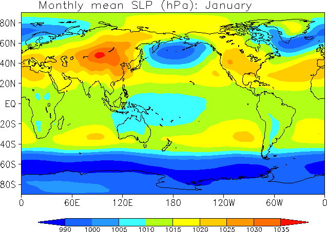
Again, winter cloud isn't necessarily caused disturbed weather events. It could be stably cloudy, for example. Here's an average pressure map of the world in January:
Cloudy Europe isn't really any different relatively less cloudy North America. Looking at deviation in surface pressure (10 day period) gives an indication of how disturbed the weather is:
For North America in the winter, the cloudy Great Lakes has no lower sea pressure than the sunnier Atlantic Coast. For Europe, there's little east-west variation in pressure, though the UK has lower pressure than most of Europe.
Location: Segovia, central Spain, 1230 m asl, Csb Mediterranean with strong continental influence, 40º43 N
3,094 posts, read 3,572,785 times
Reputation: 1036
Quote:
Originally Posted by dunno what to put here
continental climates of central and eastern Europe are much cloudier than the oceanic regions to the west, by quite a margin. The difference is less stark or even reversed in summer, obviously.
There are also some differences in average yearly sunshine inside some western European countries of mainland continental Europe, as you can see in the following climate maps of The Netherlands.
Note the slight sunshine peak of early autumn, with the most clear days. Midsummer actually less clear days than most of the year, though the variation is slim.
Location: Segovia, central Spain, 1230 m asl, Csb Mediterranean with strong continental influence, 40º43 N
3,094 posts, read 3,572,785 times
Reputation: 1036
Quote:
Originally Posted by nei
take a look at this diagram of NYC:
Note the slight sunshine peak of early autumn, with the most clear days. Midsummer actually less clear days than most of the year, though the variation is slim.
Note the slight sunshine peak of early autumn, with the most clear days. Midsummer actually less clear days than most of the year, though the variation is slim.
For comparison sake, here is how my part of the world compares (semi-arid Penticton).
Looks like a warm summer morning with the milky skies and green vegetation. Is there a way to find out the date of the photo? I'm not really familiar with the new interface.
Yes, Winter is cloudiest and gloomiest and Fall is generally the Sunniest season here in Indianapolis, Indiana, U.S..
Please register to post and access all features of our very popular forum. It is free and quick. Over $68,000 in prizes has already been given out to active posters on our forum. Additional giveaways are planned.
Detailed information about all U.S. cities, counties, and zip codes on our site: City-data.com.

 Please register to participate in our discussions with 2 million other members - it's free and quick! Some forums can only be seen by registered members. After you create your account, you'll be able to customize options and access all our 15,000 new posts/day with fewer ads.