Please register to participate in our discussions with 2 million other members - it's free and quick! Some forums can only be seen by registered members. After you create your account, you'll be able to customize options and access all our 15,000 new posts/day with fewer ads.
Still got about 3-4 hours of useful heating left. This is what summer is supposed to be, not that low 20's cloudy rubbish that characterised Dickcember and January until now.
Alas, long term averages for Melbourne indicate you're doomed to have many more days near 20C than 40C. Enjoy it while you can! And remember, as bad as Melbourne may seem there are far worse places. Try coming to Edmonton some time.
After an ice cold overnight low of 5 C (the average low in May or September) we managed to break 20 C for a couple of hours before the sky clouded over and the 35 kph southerly started back up. The rest of the week and probably all of next week looks like being the same rubbish.
Location: The Valley Of The Sun just east of Canberra
414 posts, read 798,289 times
Reputation: 362
You can thank the blocking high in the Tasman for that. The Tasman Sea high brings heatwaves to SE Aus and cold SW'ly changes to NZ on the other side. I noticed Invercargill was 9C at Midday yesterday! In terms of the number of 30C+ days, Christchurch has it better than most though because of the Foehn Effect. I'd imagine Greymouth on the opposite coast rarely sees 30C.
Still got about 3-4 hours of useful heating left. This is what summer is supposed to be, not that low 20's cloudy rubbish that characterised Dickcember and January until now.
Apparently your new troll station made it to 42C, not bad eh
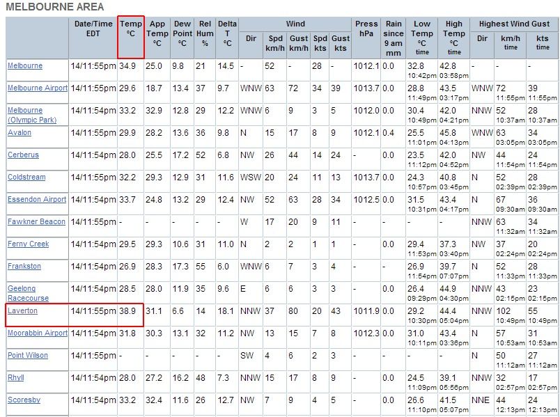
And the full list of Victorian Obs. Lots of 44's, pretty much the entire NW corner of the state (the "Mallee" in the obs) exceeded 45C with even a 46.5C reading at Charlton! What a day!
Winds have turned to northerly and we have a thick blanket of cloud trapping the heat, so there is a very good chance it won't go below 30C tonight, and we might break the record for the highest overnight low.
Thursday night into Friday looks like it could be the most epic of hot nights though, with an approaching cold front compressing all the heat ahead of it and 850 temps overnight are progged to be about 2C hotter than tonight.
I've never seen temps like this at this time of night. This is just about inconceivable, before tonight, if anyone told me that this can occur here I would've laughed in their face
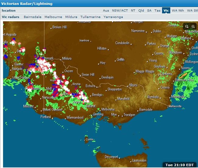
Radar shows a thin band of light rain between Melbourne city and the airport, but apparently this is infact a lightning active storm according to the lightning tracker...
Looking forward to what this is gonna yield. Does Oz take minimum temp as being between 12am and 12am or 6am and 6am?
Btw, this is some pretty dry heat - 6.7C dewpoint
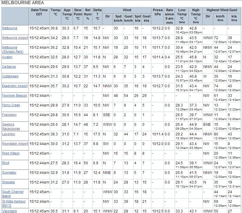
the BOM takes the min 9am-9am, which is stupid IMO as it has destroyed many high overnight lows from the record. The thing is, if the overnight temp remains higher than the temp at 9am the previous morning, then the "overnight" low will actually be recorded as that 9am temp.
As of 1:30am, the overnight low in Melbourne is currently 32.8C, but the temp at 9am the previous morning was 31.1C. So even if the temp stays above 32.8C all night until 9am today, the low will still be recorded as 31.1C Either way, it will still be an official record.
I actually can't see us dropping below 30C tonight, we have a very hot airmass, full cloud cover and northerly winds. The record high low is 30.6C, and that is under serious threat right now.
Please register to post and access all features of our very popular forum. It is free and quick. Over $68,000 in prizes has already been given out to active posters on our forum. Additional giveaways are planned.
Detailed information about all U.S. cities, counties, and zip codes on our site: City-data.com.

 Please register to participate in our discussions with 2 million other members - it's free and quick! Some forums can only be seen by registered members. After you create your account, you'll be able to customize options and access all our 15,000 new posts/day with fewer ads.


") Either way, it will still be an official record.
Either way, it will still be an official record. 
