Please register to participate in our discussions with 2 million other members - it's free and quick! Some forums can only be seen by registered members. After you create your account, you'll be able to customize options and access all our 15,000 new posts/day with fewer ads.
Why are you focusing just on the average daily minimums?
Why not the daily highs or the daily average?
Obviously as you go farther inland, lows will tend to go lower, especially at winter.
Having said this, you must take into consideration how far from the sea is the station you are comparing with the sea, and the existence of an urban heat island. Few miles can mean a couple of degrees.
What some people forget is the wind factor. Here on the Northeast coast water temps have no effect in air temps if the winds are coming from the North or NorthWest. Water temps do not control the air above especially over land. The other factor is clouds. If you get a clear night, goodbye warm air at the surface.
With that said... My minimums go as low as teens with water temps still in the 40/50sF. And in the summer can go as low as 50s with water temps in the 70s. It's all dependent on current weather factors.
Using what I have handy right now is current. Shaded map on left is the temps at 4000 feet up in C°.
Numbers on map are the actual surface temps F°
On the right are the water temps I added the degrees in F°
As you can see, the flow is from the NorthWest now and temps at the 4000 foot level are dropping below freezing over the waters which in turns drops the surface temps as well. I'm in the upper 20s here near the coast while the water temps are upper 40s.
These are the times when water temps don't matter much. Sure there's an effect (that's called thermal gradient) You can even see Long Island and the coast. Low 30s not much different from upper 20s right now.
Atlantic City New Jersey at 29°F while water temp is 46 degrees.
Great points and great maps. Where you get those coastal water temp maps? btw, I subscribe now to Weather Bell and have access to all their models. I love it.
Sea temperature is about 3-5°C (37-41°F) in February when its the coldest time of year and about 18-20°C (64-68°F) in August, when it is warmest. This also varies somewhat, so the water temperature in drop close to zero in cold winter where ice floes drift in the water and vise versa in hot prolonged summers the water temperature can reach up to 23°C.
Our average minimum in January/February is about -1°C (30°F) and in return the average minimum in July/August is 14°C (57°F)- so the difference between sea temperature and air temperature would be about 5 degrees (C) or 9°F both in winter and summer.
Water Temps in Gulf of Mexico off Corpus Christi Texas is 57°F. Its currently 37°F at Corpus Christy. Its the air flow and strength of air that matters in surface/air temps.
What some people forget is the wind factor. Here on the Northeast coast water temps have no effect in air temps if the winds are coming from the North or NorthWest. Water temps do not control the air above especially over land. The other factor is clouds. If you get a clear night, goodbye warm air at the surface.
With that said... My minimums go as low as teens with water temps still in the 40/50sF. And in the summer can go as low as 50s with water temps in the 70s. It's all dependent on current weather factors.
All of this is completely correct…but as is typical it shows only the cold angle of things – lol.
On the East Coast water temps have a massive effect on air temps if winds are coming from the south, southwest. The warmth of the ocean can surge inland more than 50 miles if the flow is stronger enough. It’s VERY common for mid latitude storms in winter to head toward the Great Lakes or ride up the East Coast on the western spine of the Appachalina Mts and pull all the mild warm Atlantic air right into the coastal plain. So areas just to the west of the big cites see snow…and the big cities (NYC to Washington DC ) and points east see rain. Plenty of times we see it raining in NYC or Baltimore only to see it snowing in Harrisburg and Scranton, PA. The powerful warmth of the Atlantic Ocean is the reason why.
With that said... My minimums can go as high as the sea surface temps in winter (occasionally the upper 40’s F). When the southerly flow is unsually strong and the warm air from the Gulf Stream is pulled toward the coast - temps as highs as the middle 50’s for lows can occur. In December 2011 Bridgeport, CT, NYC, and Atlantic City, NJ had overnight lows as warm as 56 – 58 F. In the summer if the southerly flow is strong enough, low temps and dew points in the coastal areas if the Tri-State region (NYC/NJ/CT) can match the Caribbean. A few summers ago overnight lows in the 80’s and 75 F dew points were common in NYC/NJ/CT.
Why are you focusing just on the average daily minimums?
Why not the daily highs or the daily average?
Obviously as you go farther inland, lows will tend to go lower, especially at winter.
Having said this, you must take into consideration how far from the sea is the station you are comparing with the sea, and the existence of an urban heat island. Few miles can mean a couple of degrees.
It's partly about getting a feel for just how common heat islands are.
I find it hard to believe that many coastal places at comparable latitudes to where I live, have warmer winter minimums, even though maximums, sea temperature,sunshine distance from the beach and altitude are all similar.
I'm thinking heat islands might not just be vast urban areas, but often on a smaller scale. I've often seen photos, where the weather sites look to be in the town.
Water Temps in Gulf of Mexico off Corpus Christi Texas is 57°F. Its currently 37°F at Corpus Christy. Its the air flow and strength of air that matters in surface/air temps.
The map that you posted as well as tomfalcon's one, sum up continental climates compared to oceanic ones very well - The ability of cold air originating off land, to cool the sea is very obvious.
The map that you posted as well as tomfalcon's one, sum up continental climates compared to oceanic ones very well - The ability of cold air originating off land, to cool the sea is very obvious.
I didn't know that the Gulf could get so cold.
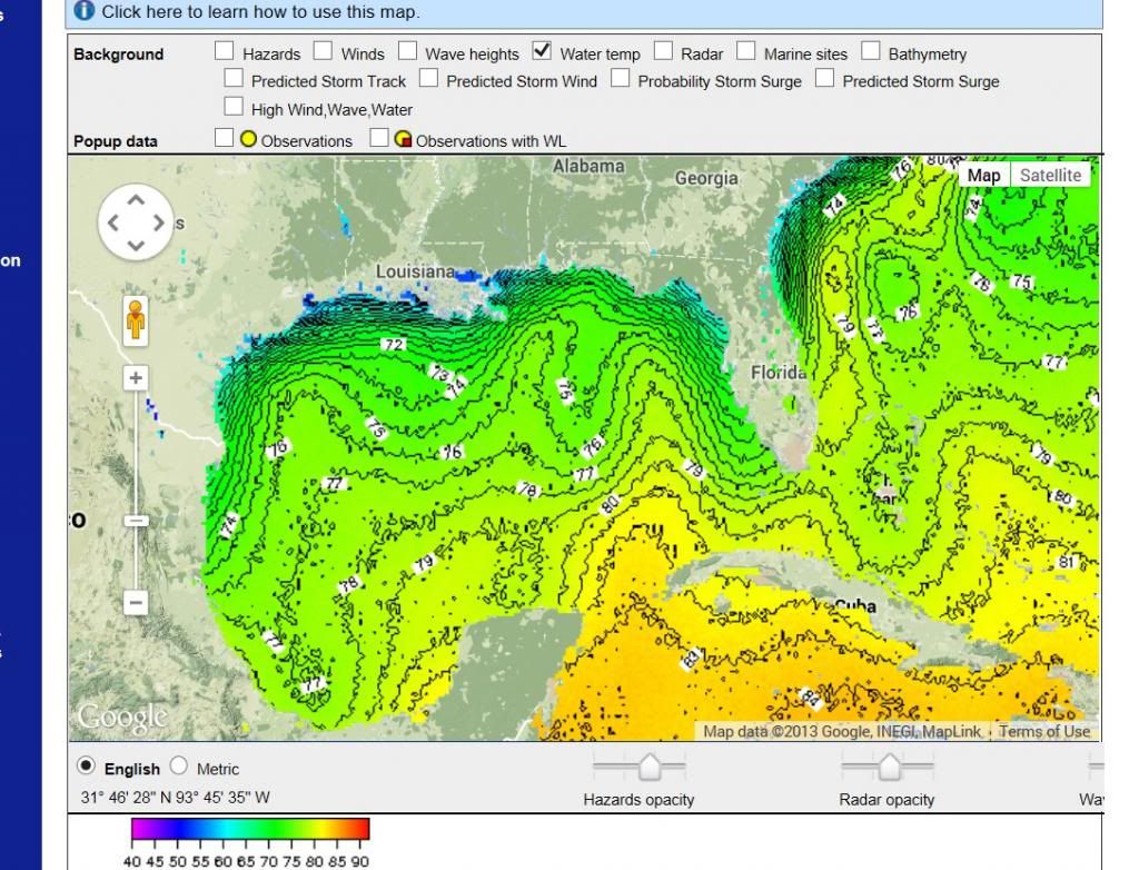
You really think these water temps are cold for the first month of winter? This is from NOAA today:
I guess it's warmed up since those maps that Cambium posted, when it was 56F and even cooler closer to shore -which would be cold for the latitude.
It certainly shows how the sea temperature can fluctuate there, much more than in Oceanic climates. All of the times I was out on the water this past winter, and the only change in water temperature, was the gradual seasonal decline. Even if temperatures were around freezing, there would be no noticeable difference from the day before.
Please register to post and access all features of our very popular forum. It is free and quick. Over $68,000 in prizes has already been given out to active posters on our forum. Additional giveaways are planned.
Detailed information about all U.S. cities, counties, and zip codes on our site: City-data.com.

 Please register to participate in our discussions with 2 million other members - it's free and quick! Some forums can only be seen by registered members. After you create your account, you'll be able to customize options and access all our 15,000 new posts/day with fewer ads.