Please register to participate in our discussions with 2 million other members - it's free and quick! Some forums can only be seen by registered members. After you create your account, you'll be able to customize options and access all our 15,000 new posts/day with fewer ads.
Between the Arctic chill in the U.S, the above normal snowfall anomalies in the Northeast, now the SouthEast could possibly get a snowstorm.
As we all know... details wont happen until we get closer. This may not even happen but lets take a look at the latest....
Euro left, Canadian middle, GFS right. All have the storm down south and enough cold air way down there. Cold enough for snow in many areas. GFS just doesn't have the moisture field as the others.
Snow totals from the Canadian. Yes, that's a foot to the North Carolina Coast. (remember, don't look at details as a guarantee) All I see is a swath of snow from Gulf coast states to Mid Atlantic States.
EURO Snow totals.
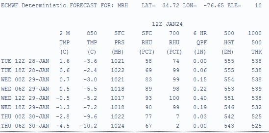
Here's Euro12z Data for Moorehead City, NC. Precip with 850s and surface near or below freezing. Amazing!
Bernie Rayno video. Always worth watching in entirety. Even if you're not in the area you can always learn something from his videos about weather. I love the "pinwheel" analogy of the arctic air.
Just to update this... GFS trending drier. Euro still shows snow. They went with dry for now.. .. Here's what NWS Wilmington, NC says.
NATIONAL WEATHER SERVICE WILMINGTON NC
558 AM EST SAT JAN 25 2014
.LONG TERM /TUESDAY THROUGH FRIDAY/...
AS OF 330 AM SATURDAY...ANOTHER ARCTIC BLAST ON TUESDAY WITH TEMPS
REMAINING IN THE 30S MOST PLACES AS COLD AND DRY HIGH PRESSURE
BUILDS IN THROUGH MID WEEK. SHORTWAVE ROTATES AROUND DEEP BROAD MID
TO UPPER TROUGH OVER THE EAST ON WEDNESDAY BUT LOOKS TO BE TOO DRY
TO PRODUCE ANY PCP. HAVE KEPT SMALL MENTION OVER COASTAL WATERS IN
THE WAY OF SNOW SHOWERS BUT LATEST GFS MODEL RUN KEEP A VERY DRY AIR
MASS IN PLACE AND THEREFORE LIKELIHOOD OF PCP REMAINS SLIM. ECMWF
SHOWS SLIGHTLY GREATER CHC FOR SOME PCP RIGHT ALONG THE COAST ON
TUES AND COLUMN WILL SUPPORT SNOW IF THIS OCCURS BUT FOR NOW WILL
TREND TOWARD A DRIER FORECAST LEAVING ALL PCP OFF THE COAST TUES OR
WED.
so GFS continues to be dry for this time period while NAM says this...
Precip type Tuesday 7pm. You can see where the Rain/Snow line is and where it's rojecting the Ice and Sleet to fall. This is NAM's long range so not so reliable yet
New Bernie video. GFS now showing it which was the drier model previously. Pretty much a front is going to sit over the southeast, warm to south, cold air driving into it on the north side of it.
Energy and a Low system rides along this front. Snow to north of the front, rain to south of it. Simple as that..
Whats not simple is figuring out HOW MUCH liquid, and WHERE it sets up!
Alabama, Florida, Georgia, Missisippi, North Carolina, South Carolina, & Texas are the only ones in the U.S to have a Winter Storm "Watch".
Obviously there are warnings and advisories out there too and blizzard Warnings but interesting to see the only watches are down there right now.
Please register to post and access all features of our very popular forum. It is free and quick. Over $68,000 in prizes has already been given out to active posters on our forum. Additional giveaways are planned.
Detailed information about all U.S. cities, counties, and zip codes on our site: City-data.com.

 Please register to participate in our discussions with 2 million other members - it's free and quick! Some forums can only be seen by registered members. After you create your account, you'll be able to customize options and access all our 15,000 new posts/day with fewer ads.