Please register to participate in our discussions with 2 million other members - it's free and quick! Some forums can only be seen by registered members. After you create your account, you'll be able to customize options and access all our 15,000 new posts/day with fewer ads.
Checking on the freon level this weekend and turning on the AC anyways. I will pay dad his $15 for 2 days of full use. A high of 86 F is way too hot for may.
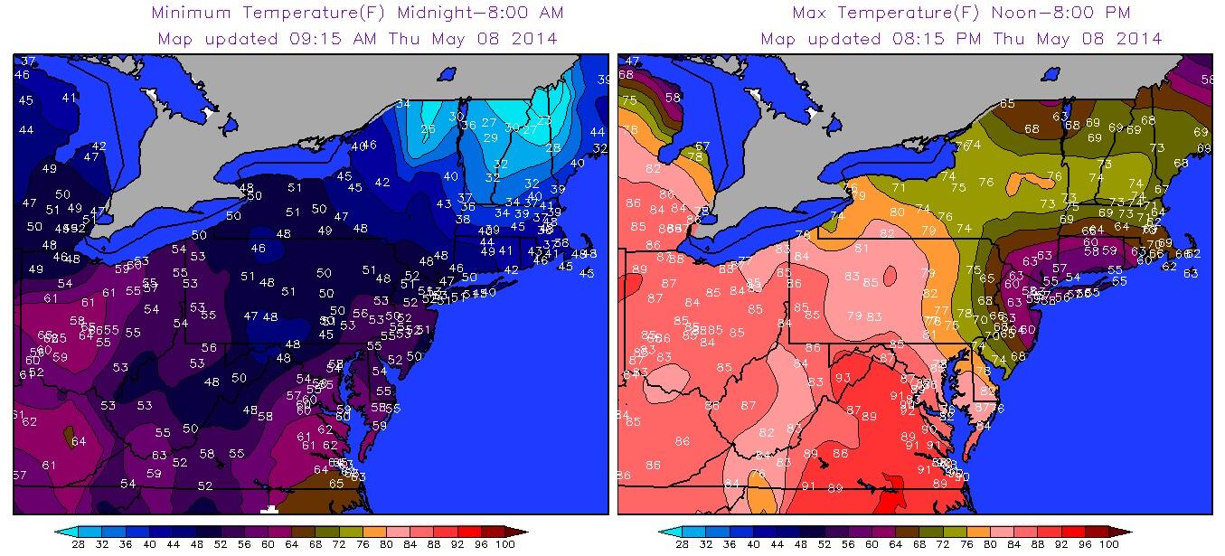
CT surrounded by A circle of 70s and inside a Bubble of Clouds for southern New England today. Looks like some areas in northern tier went from 20s to 60s.
CT surrounded by A circle of 70s and inside a Bubble of Clouds for southern New England today. Looks like some areas in northern tier went from 20s to 60s.
Very intriguing maps there! I was also sort of stuck under the same airmass that you were Cambium, although to a lesser degree. It only rose to about 66 degrees here late in the afternoon, but due west of me in Pittsburgh, it got up to 90 degrees!
The July-level warmth which burst onto the atmospheric stage here Thursday produced a shift in temps which was as breathtaking as it was unusual. Only the day before, a number of areas close to Lake Michigan struggled to get into the 50s.
O’Hare’s 89-degree high Thursday was a complete reversal of that trend and 21-degrees above normal. The reading was the highest to occur so early in a season over the past 12 years and the highest May 8 reading which has occurred here in over half a century. Not since 1963, when temps soared to 91-degrees, has the date been any warmer.
On the South Side, the 93-degree high at Midway, where observations of temperatures have been kept since 1928, set a new record. That reading has been exceeded only twice this early in the year since observations began at the site 86 years ago. The two instances in which a warmer temperature has occurred this early there have included a 94-degree high on May 5, 1949; the other a 93-degree high recorded in the Dust Bowl year of 1934 on May 6.
2 Thunderstorms in 4 hours. 2:30am. 6:30am. Temps still in the 50sF°. Warm Front battling the cooler air still. Slow to move.
Warm week coming up and muggy. Then the cool down after mid month still looks to be on tap. 30s back in the picture for ChicagoGeorge.
GFS6z data for NYC. Focusing on those dewpoints. Looks like Monday and Tuesday will be the warmest/muggiest for the area
Remember to add subtract few degrees for max min because these don't show that
Last edited by Cambium; 05-09-2014 at 05:32 AM..
Please register to post and access all features of our very popular forum. It is free and quick. Over $68,000 in prizes has already been given out to active posters on our forum. Additional giveaways are planned.
Detailed information about all U.S. cities, counties, and zip codes on our site: City-data.com.

 Please register to participate in our discussions with 2 million other members - it's free and quick! Some forums can only be seen by registered members. After you create your account, you'll be able to customize options and access all our 15,000 new posts/day with fewer ads.


")


 . Ready to tackle the hot weather early next week.

