Please register to participate in our discussions with 2 million other members - it's free and quick! Some forums can only be seen by registered members. After you create your account, you'll be able to customize options and access all our 15,000 new posts/day with fewer ads.
Nice whiteout here right now. Went from barely snowing at 5pm to everything covered now at 6pm. Somehow I doubt we'll only get 1 inch of out this as predicted. It's looking like we'll get more out of this one.
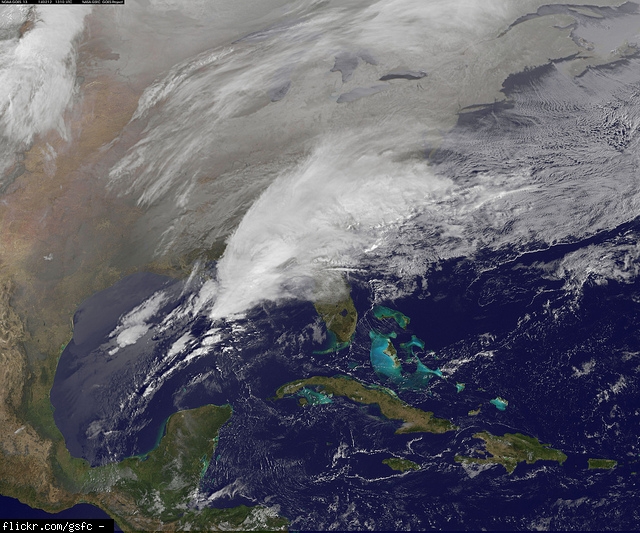
Yep. I was right. There's already 1 inch on the ground! Just went out and measured. 1 inch in just under an hour. And we've got how many hours of this left?! Looks solidly blue on the radar.
Yep. I was right. There's already 1 inch on the ground! Just went out and measured. 1 inch in just under an hour. And we've got how many hours of this left?! Looks solidly blue on the radar.
Nice!! Enjoy! Some of it is convective stuff which can surprise a few with heavier rates. You might squeeze 2-3" from it. Not a lot of moisture around
Nice!! Enjoy! Some of it is convective stuff which can surprise a few with heavier rates. You might squeeze 2-3" from it. Not a lot of moisture around
Thanks! We're already on the high end of that. Just went for a nice, long, snowy walk. When I got back, I measured it again. About 2.5 inches as of 7 PM. Still coming down. Maybe we can squeeze 4'' from it yet!
What's the weather looking like for the Feb 14-17th timeframe?
14-17 should be dry and warm there quickly looking at the GFS.
You have to watch before that. 14th would be a storm for us. So that means 12th/13th for you. Expect low to form in Gulf and bring you rain on the 12th
Ok, lets look at some discussions then I'll start showing some model updates in the morning. They all agree on this storm. Now its details, details, details we watch. Track is part of that
NWS Mt Holly
THE CENTER OF AN EXTENSIVE AREA OF HIGH PRESSURE IS FORECAST TO
MOVE FROM MINNESOTA AND IOWA ON MONDAY EVENING TO NORTHERN NEW
ENGLAND AND SOUTHERN QUEBEC ON WEDNESDAY MORNING. THE HIGH WILL
INFLUENCE OUR REGION DURING THAT PERIOD WITH COLD DRY WEATHER
CONDITIONS.
WE WILL GO WITH MORE SNOW AND LESS RAIN IN THE NEW FORECAST BASED
ON THE COLDER MODEL TRENDS. THERE REMAINS THE POTENTIAL FOR A
SIGNIFICANT ACCUMULATION OF SNOW IN PART OF OUR FORECAST AREA.
----------------------
NWS Upton
HIPRES TUE-WED WILL BRING FAIR WX TO THE CWA. FCST TEMPS A BLEND OF
GUIDANCE.
MAIN FOCUS IS THEN THE POTENTIAL STORM IN THE WED NGT THRU THU TIME
PERIOD. THE 12Z ECMWF IS THE BEST FIT TO THE GFS ENSEMBLES. THE
OPERATIONAL GFS IS SLOWER...WEAKER AND FURTHER E THAN THE MODEL
CONSENSUS WHICH INCLUDED A VERY DEEP GEM. AS A RESULT FCST HAS
BEEN TRENDED TOWARDS A COLDER
---------------------
NWS Boston
WEDNESDAY NIGHT THROUGH THURSDAY...A COASTAL STORM MAY BRING
ANYTHING FROM SNOW TO A WINTRY MIX TO RAIN TO SOUTHERN NEW ENGLAND.
---------------------
NWS Wakefield
MODELS IN BETTER AGREEMENT NOW WITH NRN STREAM AND SRN STREAM ENERGY
PHASING INTO A POTENT SHORTWAVE OVER THE GULF STATES LATE WEDS INTO
THURS. STRONG SPEED MAX WILL ROUND THE BASE OF THE
SHORTWAVE...EJECTING THE FEATURE NEWD THURS MORNING. CYCLOGENESIS
WILL BE ONGOING TO BEGIN THE EXTENDED PERIOD AS THE SFC LOW
STRENGTHENS ALONG A TRAILING COLD FRONT OFF THE SE COAST.
Please register to post and access all features of our very popular forum. It is free and quick. Over $68,000 in prizes has already been given out to active posters on our forum. Additional giveaways are planned.
Detailed information about all U.S. cities, counties, and zip codes on our site: City-data.com.

 Please register to participate in our discussions with 2 million other members - it's free and quick! Some forums can only be seen by registered members. After you create your account, you'll be able to customize options and access all our 15,000 new posts/day with fewer ads.

 Went from barely snowing at 5pm to everything covered now at 6pm. Somehow I doubt we'll only get 1 inch of out this as predicted. It's looking like we'll get more out of this one.