Please register to participate in our discussions with 2 million other members - it's free and quick! Some forums can only be seen by registered members. After you create your account, you'll be able to customize options and access all our 15,000 new posts/day with fewer ads.
I was in Boston a few days ago and brought my bicycle. Trying an Ariete-style city photo tour. Only had a few hours to ride and take photos, so was a bit limited. Boston felt rather pleasant to bike in, much more so than New York City and even San Francisco (might just be the areas I chose). Though Boston has some spots near highways that are hostile to anyone not in a car, worse than almost anywhere in New York City. Boston always struck as similar in scale to San Francisco, but very different in look and surroundings.
Jamaica Plain neighborhood in Boston. Was historically mostly Irish-American until maybe the 60s, was one of the nicer Irish neighborhoods. Today, it's a mix of immigrants as well as "gentrifier" types, though it's not a wealthy neighborhood. Someone told me his ancestors left Jamaica Plain in the late 1800s from all the "lower-class" Irish moving in...
while old residential neighborhoods in New England are mostly made of, commercial buildings are usually brick:
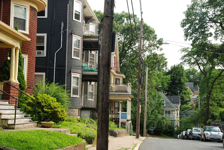
Local houses are wood, mostly not single family, but divided into multiple units.
Boston has some small hills:
This house is single family:
I like the turret:
Narrow street for Boston:
Backs of some homes:
Some more homes:
Spoiler
Homes with three balconies are called triple-deckers. Common housing style in older New England cities.
Same narrow street as before but looking in the opposite direction:
Passed by a big Dominican festival in a local park. Not sure what it was for, very crowded with loud music. People seemed festive and happy.
Musicians:
Spoiler
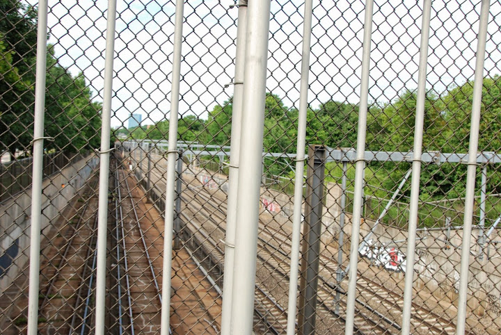
Now going northeast towards downtown. Southwest Corridor. An expressway was planned to go southwest of downtown through Boston, expanding space that previously held a railroad line. The expressway was cancelled due to community opposition, but some of the demolition had already been done. Some of the space was used for local rapid transit (subway line) which used to run elevated on top of a commercial street. The subway tracks were placed next to the already existing longer distance train tracks.. The remaining space on the side was turned into a bike path, with a small linear park and gardens. I used the bike path, here are the train tracks next to it:
Five tracks total, the bike path is to the left. And the bike path next to a brutalist subway station:
City bike rental station is new. Housing project to the left isn't, I tried to be quick taking a photo, area felt busy enough I wasn't too worried. Afterwards, the path passed through one of the worst neighborhoods of Boston but the path itself felt fine. Near the end of the path:
Now at a commercial street just south of downtown:
Residential streets look a bit similar in scale and look to older Brooklyn residential streets:
But some are almost right next to skyscrapers:
End of the bike path turns into a walkway of park and gardens surrounded by apartment buildings:
On the way back, passed through Arnold Arboretum. From the top of a small hill:
Out of focus skyline shot. A lot more would have been visible without the tree leaves.
I was in Boston a few days ago and brought my bicycle. Trying an Ariete-style city photo tour. Only had a few hours to ride and take photos, so was a bit limited. Boston felt rather pleasant to bike in, much more so than New York City and even San Francisco (might just be the areas I chose). Though Boston has some spots near highways that are hostile to anyone not in a car, worse than almost anywhere in New York City. Boston always struck as similar in scale to San Francisco, but very different in look and surroundings.
Jamaica Plain neighborhood in Boston. Was historically mostly Irish-American until maybe the 60s, was one of the nicer Irish neighborhoods. Today, it's a mix of immigrants as well as "gentrifier" types, though it's not a wealthy neighborhood. Someone told me his ancestors left Jamaica Plain in the late 1800s from all the "lower-class" Irish moving in...
while old residential neighborhoods in New England are mostly made of, commercial buildings are usually brick:
Local houses are wood, mostly not single family, but divided into multiple units.
Boston has some small hills:
This house is single family:
I like the turret:
Narrow street for Boston:
Backs of some homes:
Some more homes:
Spoiler
Homes with three balconies are called triple-deckers. Common housing style in older New England cities.
Same narrow street as before but looking in the opposite direction:
Passed by a big Dominican festival in a local park. Not sure what it was for, very crowded with loud music. People seemed festive and happy.
Musicians:
Spoiler
Now going northeast towards downtown. Southwest Corridor. An expressway was planned to go southwest of downtown through Boston, expanding space that previously held a railroad line. The expressway was cancelled due to community opposition, but some of the demolition had already been done. Some of the space was used for local rapid transit (subway line) which used to run elevated on top of a commercial street. The subway tracks were placed next to the already existing longer distance train tracks.. The remaining space on the side was turned into a bike path, with a small linear park and gardens. I used the bike path, here are the train tracks next to it:
Five tracks total, the bike path is to the left. And the bike path next to a brutalist subway station:
City bike rental station is new. Housing project to the left isn't, I tried to be quick taking a photo, area felt busy enough I wasn't too worried. Afterwards, the path passed through one of the worst neighborhoods of Boston but the path itself felt fine. Near the end of the path:
Now at a commercial street just south of downtown:
Residential streets look a bit similar in scale and look to older Brooklyn residential streets:
But some are almost right next to skyscrapers:
End of the bike path turns into a walkway of park and gardens surrounded by apartment buildings:
On the way back, passed through Arnold Arboretum. From the top of a small hill:
Out of focus skyline shot. A lot more would have been visible without the tree leaves.
Nice photos, although in the first one those girls don't look too happy you are taking their picture.
I like the one that you said looked like Brooklyn. Those trees look less dense and don't make street dark from blocking all the light. Not many streets like that here where they are treed yet still bright.
It was meant to be built up and an extention to the city in the 1910-1920's, but for some reason it never got going but for some earlier development. It was left alone and eventually used for industry, bus and tram depots, parking lots and like auto repair shops. Now the area is quite desolate, and practically a forgotten part of town. It's about to change, though: the buildings that can are been renovated and the remainder have already been demolished, along with most of the industry halls and depots. A new district of the town is being built - entirely of wood.
Spoiler
Some of the main street buildings are already ready and have new inhabitants:
Backyard:
Some very much work in progress:
Neighboring railroad tracks and practically just overgrown wilderness:
Some houses are done and inhabited, others still need a facelift:
A few hideous 50's developments were built hastly to just get some apartments, and by the look at them and some of the residents, those are council housing. Probably are being razed after their lifespan ends.
These are empty, but the inner yard is being modernised to the 21st century standards:
Nice small neighbourhood:
Other areas not yet:
You can see the old prison as well up there. It's very quite and green, but totally devoid of any services. There's an elementary school, a pizza kiosk, and a very shabby bar I wouldn't set my foot in. The plans for the area have a lot of shopping space involved on street level, so the aim is that the area will not be a supermarket neighbourhood but a lively extension of the city.
On a hill there's the old seafaring and -captain school, now abandoned as well. The building will probably be razed in due time. The location and view is excellent, could be nice for a few rowhomes or similar:
You can even see the castle from there:
The hillside has an interesting unmanipulated micro ecosystem with deciduous trees in all forms. Our forests could look like that if the spruces and birches would f*ck off:
Raspberry bushes as well with ripe berries. Too bad they are unreachable:
And a small park:
What this is, I don't know, some hybrid maybe:
Ash, maple and oak all in one heap:
Even some wild apple trees:
And suddenly there was some thunder and heavy rain started falling. Sunshower!
Took cover under a big-ass maple and hoped for the worst to pass:
Some early development, and then the area was just left unbuilt thereafter:
The rain eased for a while and I decided to return home. Lush and green on the main street as well:
NIMBY attitude as its worst. This empty plot is being planned to be built, but the residents in the house in the background of course do whatever they can, AS THEIR VIEW IS OBSCURED (and 2 lowest floors only:
But dark clouds kept forming:
Ducks!
The old medieval street by the cathedral school. Would be a lot more of them if the city wouldn't had been burnt down completely the last time. What a pity. The Swedish empire's second largest city totally destroyed forever.
And couldn't go home without saying hello to these suckers. They've grown:
I was supposed to take some pictures of the street life as well, but was so soaking wet so it has to wait. Was warm rain though in the beginning at least, as it was 31C when it started.
Oh, and there's a overview how the area plan is for the first phase. Not autocentric! Yellow existing, white new:
Please register to post and access all features of our very popular forum. It is free and quick. Over $68,000 in prizes has already been given out to active posters on our forum. Additional giveaways are planned.
Detailed information about all U.S. cities, counties, and zip codes on our site: City-data.com.

 Please register to participate in our discussions with 2 million other members - it's free and quick! Some forums can only be seen by registered members. After you create your account, you'll be able to customize options and access all our 15,000 new posts/day with fewer ads.