Welcome to City-Data.com Forum!
U.S. CitiesCity-Data Forum Index
Go Back   City-Data Forum > General Forums > Weather
 [Register]
Please register to participate in our discussions with 2 million other members - it's free and quick! Some forums can only be seen by registered members. After you create your account, you'll be able to customize options and access all our 15,000 new posts/day with fewer ads.
View detailed profile (Advanced) or search
site with Google Custom Search

Search Forums  (Advanced)
 
Old 12-27-2014, 04:01 PM
 
Location: Near the Coast SWCT
83,500 posts, read 75,234,500 times
Reputation: 16619

Advertisements

Quote:
Originally Posted by Infamous92 View Post
I thought our climates were fairly similar, but ISP's avg max for this time of year is in the lower 40's.

December is running 4F above normal (as of yesterday), I'm enjoying it.
Hmmm. I got Islip at 40° for the normal max today. Across the way in Bridgeport its 39°. Danbury is 36°. I'm usually in between Danbury and Bridgeport climate so closer to upper 30s actually, not mid 30s like I said.
Reply With Quote Quick reply to this message

 
Old 12-27-2014, 04:44 PM
 
Location: Near the Coast SWCT
83,500 posts, read 75,234,500 times
Reputation: 16619
Want snow? Head to Texas. Winter Storm Warnings for 5 counties there. 4-6" this evening and overnight.

Reply With Quote Quick reply to this message
 
Old 12-27-2014, 04:46 PM
 
Location: Paris
8,159 posts, read 8,727,553 times
Reputation: 3547
Snowfall now widespread. Apparently Paris' western exurbs got hit by a small snowy front:


Noon temps over Fennoscandia:


Forecasts beginning to show single digit °F afternoon temps for Alsatian towns. Wish I was there:

Reply With Quote Quick reply to this message
 
Old 12-27-2014, 05:35 PM
 
Location: Near the Coast SWCT
83,500 posts, read 75,234,500 times
Reputation: 16619
Quote:
Originally Posted by Rozenn View Post
Snowfall now widespread. Apparently Paris' western exurbs got hit by a small snowy front:
Nice to see. Interesting icons. Wonder why they chose orange instead of blue or white. Is the V looking one mean wind?

Figures you guys get cold and snow when we're warm here in the East.

--------------------

Max temps by State per ASOS site today:

Farmville, Virginia: 69°F
Salisbury, Maryland: 65°
York, PA: 60°
Atlantic City, New Jersey: 59°
Hartford Connecticut (BDL): 55°
NYC: 55° tied with others
Taunton, MA: 54°
Providence, Rhode Island: 53°
Portland, Maine: 52°
Nashua, New Hampshire: 52°
Bennington, Vermont: 47°
Reply With Quote Quick reply to this message
 
Old 12-27-2014, 05:44 PM
 
Location: Paris
8,159 posts, read 8,727,553 times
Reputation: 3547
They use the same color for every icon (snow, tstorms, rain, wind... you name it). Red means that the event occured in the past hour. The lighter the color, the older the observation (you can see it on the legend at the upper left corner of the image). And yup, the V means wind.


Quote:
Originally Posted by Cambium View Post
Figures you guys get cold and snow when we're warm here in the East.
It's more the randomness of weather events. Sometimes, we're mild and you're cold - or vice versa. Other times, we both get cold (or mild) weather.
Reply With Quote Quick reply to this message
 
Old 12-27-2014, 07:09 PM
 
Location: California
393 posts, read 345,346 times
Reputation: 494
Most stations in the downtown New York area recorded warmer low temperatures than Los Angeles did last night.

12/27/2014:
New York City (Central Park): 55°F/43°F
Downtown Los Angeles (USC Campus): 63°F/39°F

How often does that happen, huh? I recorded a high of 58°F today and a low of 34°F last night, here in Murrieta (about 76 miles from Downtown Los Angeles).
Reply With Quote Quick reply to this message
 
Old 12-28-2014, 03:34 AM
 
Location: Finland
24,128 posts, read 24,792,350 times
Reputation: 11103
Pretty frigid out there:


90F the hottest temp in my metro area.
Reply With Quote Quick reply to this message
 
Old 12-28-2014, 05:36 AM
 
Location: Near the Coast SWCT
83,500 posts, read 75,234,500 times
Reputation: 16619
More Rain this morning! Over 6.50 inches for the month.

Current Temps 7amEST. F°. Colder west of Mississippi all the way to south Texas than it is in Vermont!

Hartford 45 Oklahoma City 22.
Bridgeport 46 Little Rock 39.
Philly 45 San Antonio 37.
NYC 48 Dallas 35.
Burlington 45 Wichita 17.
Portland 43 Sioux City 2
Washington DC 53 Corpus Christi 44
Reply With Quote Quick reply to this message
 
Old 12-28-2014, 06:22 AM
 
Location: New Jersey
15,318 posts, read 17,212,899 times
Reputation: 6959
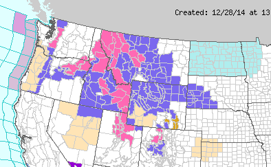
Winter Storm Warnings and Advisories in much of the western US. Windchill advisories in North Dakota and Minnesota with values down to -30 F/-34 C.


NWS Rapid City, South Dakota:

...SNOW AND ARCTIC AIR ON THE WAY...

.AN ARCTIC COLD FRONT WILL SLIDE SOUTH ACROSS THE AREA TODAY...WITH
TEMPERATURES DROPPING THIS AFTERNOON. AN UPPER LEVEL SYSTEM WILL
CROSS THE REGION THIS AFTERNOON THROUGH EARLY MONDAY...BRINGING
WIDESPREAD SNOWFALL. SNOWFALL AMOUNTS OF 2 TO 4 INCHES ARE
EXPECTED ACROSS THE ADVISORY AREA BY LATE MONDAY MORNING.
TEMPERATURES WILL DROP TO NEAR OR BELOW ZERO MONDAY MORNING...WITH
WIND CHILL VALUES OF 5 BELOW TO 20 BELOW ZERO LATE TONIGHT AND
MONDAY MORNING.

NWS Missoula, Montana:

A WINTER STORM WARNING REMAINS IN EFFECT UNTIL 11 PM MST /10 PM
PST/ THIS EVENING.

* IMPACTS/TIMING: SNOW WITH MODERATE TO HEAVY RATES OF 1 TO 2
INCHES OR MORE PER HOUR WILL CONTINUE THROUGH THIS MORNING.
TRAVEL WILL BE DANGEROUS AT TIMES DUE TO SLICK SNOW COVERED
ROADS...PERIODS OF HEAVY SNOW...AND REDUCED VISIBILITY.

* SNOW ACCUMULATIONS: 4 TO 8 INCHES IN THE VALLEYS... 10 TO 15
INCHES IN THE HIGHER TERRAIN AND OVER LOLO AND LOST TRAIL
PASSES. AMOUNTS COULD BE LOCALLY HIGHER.

NWS Pocatello, Idaho:

A WINTER STORM WARNING FOR MODERATE TO HEAVY SNOW AND BLOWING SNOW REMAINS
IN EFFECT UNTIL 5 PM MST THIS AFTERNOON.

* TIMING...THROUGH THIS AFTERNOON.

* SNOWFALL...AN ADDITIONAL 2 TO 4 INCHES IN THE MOUNTAINS FROM
NEAR GALENA SUMMIT THROUGH THE STANLEY AREA. THE REST OF THE
WARNING AREA WILL SEE UP TO 2 INCHES.

* IMPACTS...SNOW AND GUSTY WINDS WILL CREATE HAZARDOUS
CONDITIONS AT TIMES ESPECIALLY OVER PASSES AND THROUGH HIGHER
ELEVATION AREAS. PREVIOUS HEAVY SNOWFALL FROM THE CHRISTMAS
STORM WILL INCREASE THE LIKELIHOOD OF BLOWING AND DRIFTING
SNOW AND LOW VISIBILITY.

NWS Grand Junction, Colorado:

...WINTER STORM WARNING REMAINS IN EFFECT UNTIL 6 PM MST MONDAY...

* TIMING...LIGHT SNOW WILL DEVELOP THIS MORNING WITH THE GREATEST
ACCUMULATIONS EXPECTED TO OCCUR TONIGHT INTO MONDAY.

* SNOW ACCUMULATION...10 TO 16 INCHES.

* WINDS...WEST 10 TO 20 MPH WITH GUSTS UP TO 35 MPH...BECOMING
NORTHEAST TO EAST ON MONDAY AND WEAKENING.

* IMPACTS...ACCUMULATING SNOW WILL IMPACT TRAVEL ACROSS THE
MOUNTAINS. AREAS OF BLOWING SNOW TODAY AND TONIGHT WILL REDUCE
VISIBILITY AT TIMES.
Reply With Quote Quick reply to this message
 
Old 12-28-2014, 06:32 AM
 
Location: New Jersey
15,318 posts, read 17,212,899 times
Reputation: 6959
Meanwhile it's a wet and mild morning in the southeastern US with flash flood watches in effect. Some current temperatures:

New Orleans, Louisiana: 67 F/19 C
Birmingham, Alabama: 56 F/13 C
Atlanta, Georgia: 56 F/13 C
Columbia, South Carolina: 54 F/12 C

Not sure why it's chillier in Jackson, Mississippi: 47 F/8 C
Reply With Quote Quick reply to this message
Please register to post and access all features of our very popular forum. It is free and quick. Over $68,000 in prizes has already been given out to active posters on our forum. Additional giveaways are planned.

Detailed information about all U.S. cities, counties, and zip codes on our site: City-data.com.


Reply
Please update this thread with any new information or opinions. This open thread is still read by thousands of people, so we encourage all additional points of view.

Quick Reply
Message:


Over $104,000 in prizes was already given out to active posters on our forum and additional giveaways are planned!

Go Back   City-Data Forum > General Forums > Weather

All times are GMT -6. The time now is 10:15 AM.

© 2005-2024, Advameg, Inc. · Please obey Forum Rules · Terms of Use and Privacy Policy · Bug Bounty

City-Data.com - Contact Us - Archive 1, 2, 3, 4, 5, 6, 7, 8, 9, 10, 11, 12, 13, 14, 15, 16, 17, 18, 19, 20, 21, 22, 23, 24, 25, 26, 27, 28, 29, 30, 31, 32, 33, 34, 35, 36, 37 - Top