Please register to participate in our discussions with 2 million other members - it's free and quick! Some forums can only be seen by registered members. After you create your account, you'll be able to customize options and access all our 15,000 new posts/day with fewer ads.
Every time I see "long range forecasts" I laugh now and think its all for clicks. I have leaned more towards actual history, facts, stats, and analogs. I'd rather get a percentage chance of things rather then a dart board guess. That's pretty much what "long range forecasts" are. Throw the dart. Miss, try again.
Paul Pastelok of accuweather writes a blog for Pro members..
From his blog today
"What continues to keep me from giving up on the cold in the East are the analogs. Not only with the set that I have been using thus far, but I looked back all the way to 1950 and found a few years that either matched or closely matched the current month, December. The years that can up were 2003, 2002, 1994, 1965, 1959, and 1957. 2003 and 1959 were very close matches to this past December. The other years were good matches. 2003/2004 and 1959/1960 winter seasons were neutral ENSO while the others were moderate El Ninos. 1959 had a warmer look to January but the rest still brought the cold. So when I averaged all them out, this is the temperature departure map for January:
So, I still have some concerns about what the European weeklies and CFS weeklies are showing this far out. They lean warmer. Remember, the second half of December looked cold Plains on East based on the SSW from back in late November. Models started to trend colder too and then backed off. I still feel there is cold in January, mainly aimed northern/central Plains modifying a bit coming east, then a bigger push farther east later in the month. The Bering Sea rule supports big upper trough between the 13th and 16th, which can be followed by significant cold. Let's not go crazy yet "
Analog Pic below.
I don't know about the other years, but the all-time record low of -29 F/-34 C was set here in January 1994. How was the North American snow pack that year?
Nice to see NWS NY get deep into the technicals.. Could be a messy situation for interior.
Let me try to brush this up..
Models agree on a Closed Upper Low in the SouthWest this weekend that will move towards the Great Lakes and then possibly shifting to coast with the phasing of the jet streams. The timing is off on all models of the phasing part because there is going to be a storm bombing out near Russia this week which is sending different results downstream to America for this weekend.
Either way, a secondary low developing on the coastal plain stubborn arctic air = wintry precip.
Quote:
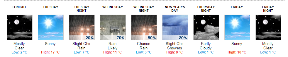
NATIONAL WEATHER SERVICE NEW YORK NY
942 AM EST TUE DEC 30 2014
LONG TERM /THURSDAY NIGHT THROUGH MONDAY/... COLD DRY WX WILL CONTINUE THROUGH FRIDAY AS HIGH PRESSURE BUILDS FROM THE WEST...WITH HIGHS GENERALLY IN THE 30S...LOWS IN THE 20S...AND WIND CHILLS ABOUT 10 DEGREES COLDER THAN AMBIENT TEMPS.
LATEST OPERATIONAL MODELS HAVE COME INTO GENERAL AGREEMENT WITH PHASING OF A NORTHERN STREAM SHORTWAVE DIGGING INTO THE NORTH CENTRAL US AND A CLOSED UPPER LOW EJECTING OUT OF THE SOUTHWEST THIS WEEKEND WITH EVENTUAL PIVOT OF THIS PHASED ENERGY INTO THE NE. THE DIFFERENCES LIE IN STRENGTH OF THESE ENERGIES AND TIMING/DEGREE OF PHASING...WHICH REFLECTS IN TRACK DIFFERENCES OF INTENSIFYING SURFACE LOW PRESSURE OVER GREAT LAKES/NORTHEAST FOR THE WEEKEND.
SBU CSTAR SENSITIVITY ANALYSIS INDICATING THIS UNCERTAINTY PARTICULARLY IN THE NORTHERN STREAM MAY BE ORIGINATING FROM EVOLUTION OF A BOMBING LOW PRESSURE EAST OF RUSSIA OVER THE NEXT 48 HRS AND RESULTANT DOWNSTREAM WAVE PACKET. SO MAY STILL TAKE A COUPLE OF DAYS TILL GREATER CONVERGENCE/CONFIDENCE IN MODELS SOLUTIONS.
WITH THAT SAID...LATEST GFS/ECMWF/CMC GUIDANCE ALL INDICATING A PRIMARY STRONG LOW PRESSURE SYSTEM TRACKING UP THROUGH THE GREAT LAKES/WESTERN NY INTO QUEBEC/NEW ENGLAND SAT NIGHT INTO SUN...WITH POSSIBLE SECONDARY DEVELOPMENT ALONG THE COASTAL PLAIN. ALL WHILE ARCTIC HIGH PRESSURE SLOWLY RETREATS. WITH RESPECTIVE ENSEMBLE MEANS ALSO SHOWING A SIMILAR PATTERN...HAVE TRENDED FORECAST IN
THAT DIRECTION.
PREDICTABILITY OF P-TYPE AT THIS TIME IS LOW BASED ON ABOVE...BUT THIS SCENARIO WOULD BE FAVORABLE FOR SNOW/WINTRY MIX TRANSITIONING TO FREEZING RAIN/RAIN (INTERIOR) AND RAIN(COAST) SAT NIGHT INTO SUNDAY. SURFACE COLD AIR MAY BE TOUGH TO SCOUR OUT OF INTERIOR VALLEY LOCALES.
OTHERWISE...POTENTIAL FOR STRONG WINDS SUNDAY ON THE BACKSIDE WITH COLDER AIR RETURNING FOR SUNDAY NIGHT-MON VIA BUILDING ARCTIC HIGH PRESSURE.
Comparing ORD's Mean temp (33.3F), Midway airport's Mean so far this December is 35.9F. Northerly Island's is 34.8F. Midway airport data going back to 1928, is seeing it's 8th mildest December (tied with 1959), though after today and tomorrow, this month will fall behind 1959 and 1994. Still disgustingly lame
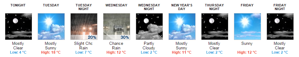
Finally might get a little snow this weekend
Cold Eastern Europe in the coming 6-10 days
Last edited by chicagogeorge; 12-30-2014 at 10:08 AM..
585 Height over Florida. 545 over Nevada from CutOff.
Colorful gradients today
70s/80s in Florida, 40s/50s in Gulf States. 30s here, just normal..
Teens in Texas and single digits in Plains is well below normal. 20-30 below. Single digits during the day. I want!
Can you find the Polar Jet Stream? I see 2 fronts near Florida. lol
Cloudy day in Orlando and Witchita, Sunny in Miami & Little Rock.
Still not far enough east. Shift the center from Illinois to Ohio, then we'd be talking. Western Atlantic ridge still looks like it's in place here.
Please register to post and access all features of our very popular forum. It is free and quick. Over $68,000 in prizes has already been given out to active posters on our forum. Additional giveaways are planned.
Detailed information about all U.S. cities, counties, and zip codes on our site: City-data.com.

 Please register to participate in our discussions with 2 million other members - it's free and quick! Some forums can only be seen by registered members. After you create your account, you'll be able to customize options and access all our 15,000 new posts/day with fewer ads.