Please register to participate in our discussions with 2 million other members - it's free and quick! Some forums can only be seen by registered members. After you create your account, you'll be able to customize options and access all our 15,000 new posts/day with fewer ads.
Since 1950, the Yukon has been able to hit 35C/95F seven times. Interestingly, the all time high was hit 10 years ago, and no one noticed.
Environment Canada and the Yukon government says that the all time record was recorded in June of 1969 (interestingly a mere half a year after the coldest winter on record) when 36.1C (97F) was recorded at Mayo.
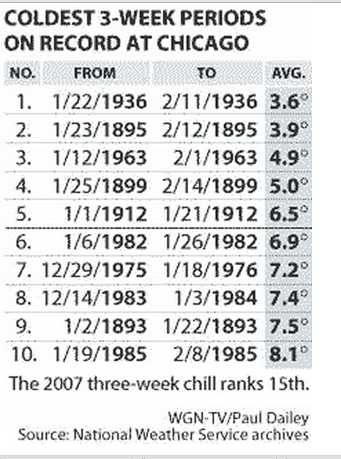
Aside: We see this same pattern in other places like the prairies in 1936 where the coldest winter on record was followed by the hottest summer on record.
His is a list of the other hot spells that hit 35C.
- June 1950 when Dawson and Mayo were 35C/95F,
- May 1983 when Forty Mile was 36C (96.8F) [I'd consider this a tie with 1969 since temperature was rounded to the nearest 0.5 degree C instead of the nearest degree F prior to the 1980s],
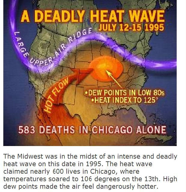
- July 1998 when Mayo Road was 35C (95F),
- June 2006 when Drury Creek was 35C (95F), and
- July 2009 when Watson Lake was a record setting 35.4C (95.7F). (This was the same time that many places further south in BC set all time records such as Vancouver, Terrace, Comox, and Abbotsford).
There was one more, and that was June 2004. In that month Mayo Road was 36.5C (97.7F). This was the hottest temperature ever recorded in the Yukon, and while the heat wave did get a lot of press for number of days above 30C, I cannot find a single media release about this new record setting temperature.
It's 10 years late, but you've heard it here first.
Just to clear up confusion, the Mayo Road weather station is near Whitehorse, and not at the town of Mayo. Also notice that instead of the typical extreme heat wavings occuring in July and August like the rest of Canada would do, they were in May, June, and July. The last heat wave in 2009 the latest 35+ heat wave because it happened on the 31st of July, which is almost a month later than the only other July occurrence from 1998.
Okay..I'll start this off talking about a cold wave we had in January 2010. We had 13 consecutive nights below 40 F (4.4 C), including 5 freezes. That is probably the longest continuous stretch of weather that cold here in recent times, although a colder temperature was recorded in December of the same year. We got down to 26 F (-3.3 C) then, and had 9 freezes that month. The average year (like last winter) doesn't usually go below 34 F (1.1 C).
Btw does anyone know what type of tree this is? It is one of the two types that show fall colors in my south florida neighborhood. The other type is more beautiful but too big for my yard
December 2010
In my opinion it's the worst cold wave I have had to live through. January 2010 was colder, but this was just too much for December.
Average Max: -5.6C/21.9F
Average: -9.0C/15.8F
Average Min: -13.7C/7.3F
Highest temperature was 0.6C (33.1F) and the lowest was -26.6C (-15.9F) with 42cm(16.5") of snow on the ground. Temperatures hit -20C (-4F) 6 times. The cold wave literally started on the 1st and finished on the 31st.
Can't really tell. It's non-native, whatever it is.
It started changing when we got some nights in the 40s with consistent 50s most nights.
Please register to post and access all features of our very popular forum. It is free and quick. Over $68,000 in prizes has already been given out to active posters on our forum. Additional giveaways are planned.
Detailed information about all U.S. cities, counties, and zip codes on our site: City-data.com.

 Please register to participate in our discussions with 2 million other members - it's free and quick! Some forums can only be seen by registered members. After you create your account, you'll be able to customize options and access all our 15,000 new posts/day with fewer ads.