Spring 2015 thread (Northern Hemisphere) (temp, date, rain, february)
Please register to participate in our discussions with 2 million other members - it's free and quick! Some forums can only be seen by registered members. After you create your account, you'll be able to customize options and access all our 15,000 new posts/day with fewer ads.
Forecast discussion from NWS Portland. Includes New Hampshire:
Short term /6 PM this evening through 6 PM Friday/...
clearing and seasonably cold tonight as surface high settles
across the region. Lows will range from around zero near the coast
to 15 below in the mountains. On Friday...mostly sunny and continued
cold under the surface ridge with high temperatures ranging from
15 to 25 degrees...or a good 15 degrees below average for the
date.
&&
Long term /Friday night through Wednesday/...
plenty of cold air remains in place during the end of the workweek
across the forecast area...with high temperatures mainly between
15 and 25 degrees from north to south. Readings should be around
40 degrees for highs in Portland this time of the year.
A week front will cross New England Saturday night. Ahead of the
front...weak warm air advection will allow temperatures to reach
the freezing level over southern sections. Full sunshine should
allow readings to reach the freezing mark over southern sections
on Sunday as well. This is still well below normal.
00z model suite still showing a weak area of low pressure crossing
over Maine and New Hampshire early Monday morning. This will bring
some snow showers or a brief period of light snow to the region.
This system will be similar to the others in that it will be
moisture starved.
Lack of Arctic air behind this departing system will allow for a
warm up early to middle next week with widespread 40s. An offshore
flow Tuesday and Wednesday will bring the warmest locations to the
coastline.
Today’s forecast is a notable deviation and nearly a reversal from the past few days. It now depicts below average temps across parts of the southern and eastern US, while above average warmth is depicted across the West and north-central US. Given the flip, GWHDDs are only 2.5 to 95.5 for the CONUS, but are up 7.9 for the East.
but
Quote:
One of the other trends within the ensembles today is that they are changing their tune with the upstream pattern over the Pacific, which may be due to how they are handling the MJO and any WestPac tropical systems. Regardless, they are backing off on the idea of the WP turning positive and driving the pattern. Instead, they right back to building heights over Alaska as the period progresses, which is a characteristic of a negative EPO. This is the same pattern driven responsible for this winters cold. This offers a cold risk for the eastern two thirds of the nation.
some very warm temperatures forecasted on sunday. looks like the east-coast will get the best of the spring-warmth. +15C isn't an impossibility locally.
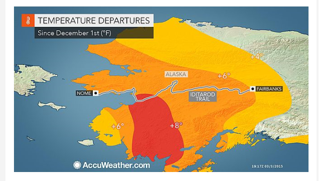
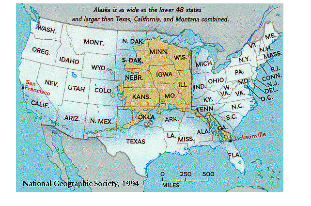
And you have to keep in mind just how large Alaska is compared to the lower 48. When combined with the western third of the US, seems a vast chunk of the US was well above average this past winter.
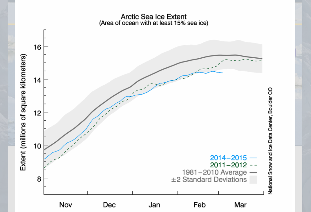
Might want to check on Arctic Sea Ice. Whoa this could possibly be the lowest max sea ice extent recorded.
That 6-10 day warmup in the NE has completely reversed. Here in central PA our forecast for Thursday March 12 has gone from 53/34 to 38/19, per accuweather.
Please register to post and access all features of our very popular forum. It is free and quick. Over $68,000 in prizes has already been given out to active posters on our forum. Additional giveaways are planned.
Detailed information about all U.S. cities, counties, and zip codes on our site: City-data.com.

 Please register to participate in our discussions with 2 million other members - it's free and quick! Some forums can only be seen by registered members. After you create your account, you'll be able to customize options and access all our 15,000 new posts/day with fewer ads.