Please register to participate in our discussions with 2 million other members - it's free and quick! Some forums can only be seen by registered members. After you create your account, you'll be able to customize options and access all our 15,000 new posts/day with fewer ads.
Do you think you'll get any of that action? NE t-storms can really rock, huh?
It's almost pitch black here. Geesus. Thunder is loud and not even close. And yet still not raining here. LOL! Just doesn't want to rain but we're about to get hit. Lightning getting frequent now.
Kinda sounds like it's breaking apart though.. About to pour cats and dogs now
Edit..
This was before the darkness... Coming from the West(left of pic).... Whooa. Gotta get off. Lightning is close
Raining now. Flood Watch in effect. 1.5 inches of rain in PA in 45 minutes!
...FLASH FLOOD WATCH REMAINS IN EFFECT UNTIL 11 PM EDT THIS
EVENING...
THE FLASH FLOOD WATCH CONTINUES FOR
* PORTIONS OF NORTHWESTERN NEW JERSEY AND NORTHEAST PENNSYLVANIA...
INCLUDING THE FOLLOWING AREAS...IN NORTHWESTERN NEW JERSEY...
MORRIS...SUSSEX AND WARREN. IN NORTHEAST PENNSYLVANIA...
CARBON...MONROE AND NORTHAMPTON.
* UNTIL 11 PM EDT THIS EVENING
* CONDITIONS ARE FAVORABLE FOR THE DEVELOPMENT OF WIDESPREAD HEAVY
RAINS FROM BANDS OF THUNDERSTORMS IN THE WATCH AREA ALONG AND
NORTH OF ROUTE 80 LATE THIS AFTERNOON AND EVENING. THESE
THUNDERSTORMS MAY PRODUCE NARROW SWATHS OF EXCESSIVE SHORT
DURATION RAINFALL... POSSIBLY AS MUCH AS 2 INCHES IN AN HOUR
WITH ISOLATED STORM TOTALS NEAR 4 INCHES. IF THESE TORRENTIAL
RAINS OCCUR... POCKETS OF DANGEROUS STREET AND HIGHWAY FLOODING
WOULD RESULT SOMETIME VERY LATE THIS AFTERNOON OR MORE LIKELY
EARLY THIS EVENING.
* THERE WAS A REPORT EARLIER THIS AFTERNOON OF 1.5 INCHES OF RAIN
IN 45 MINUTES FROM FORKS TOWNSHIP IN NORTHAMPTON COUNTY
PENNSYLVANIA.
Sky beginning to look a bit ominous to the NW, and I'm all the way in Eastern Long Island, at least an hour+ away from the storms.
Moving NE along CT line, I don't think you'll get this one. Maybe overnight as the front pushes SE more. These storms are riding the front. Yours would develop over the water or Long island itself.. These seem to be moving into CT
Almost 1 inch of rain in last half hour.
Strangely enough, NO STRONG WIND!
Thunder had a sparking sound to it then rolled. Lightning got close few times.
Good timing for my GREarth software to expire. LOL!
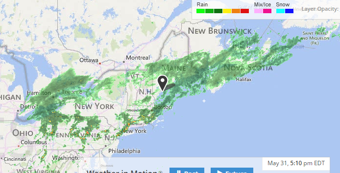
Wet weather extending from Ontario to the maritimes. Cold and raw for the last day of May in much of the Northern US and Southern Canada.
Some current conditions:
Detroit, MI: 49 F/9 C with a windchill of 44 F/7 C and rain
Toronto, ON: 47 F/8 C with rain
Buffalo, NY: 46 F/8 C with a windchill of 39 F/4 C and rain
Saranac Lake, NY: 45 F/7 C with a windchill of 39 F/4 C
Portland, ME: 52 F/11 C with a windchill of 47 F/8 C and rain
Halifax, NS: 48 F/9 C with light rain
At least you got a good rain. The wind sure is fun when it decides to rip, huh? Especially here, with our extra-tall trees...lol.
Meh. Not as exciting for us.
Please register to post and access all features of our very popular forum. It is free and quick. Over $68,000 in prizes has already been given out to active posters on our forum. Additional giveaways are planned.
Detailed information about all U.S. cities, counties, and zip codes on our site: City-data.com.

 Please register to participate in our discussions with 2 million other members - it's free and quick! Some forums can only be seen by registered members. After you create your account, you'll be able to customize options and access all our 15,000 new posts/day with fewer ads.