Please register to participate in our discussions with 2 million other members - it's free and quick! Some forums can only be seen by registered members. After you create your account, you'll be able to customize options and access all our 15,000 new posts/day with fewer ads.
How about a low pressure system that's at the leading end of a record-breaking cold front pushing east and south that gives you a nice storm with strong NW winds and gives everyone on the eastern seaboard record breaking cold temps after the front clears? I think that would make everyone happy.
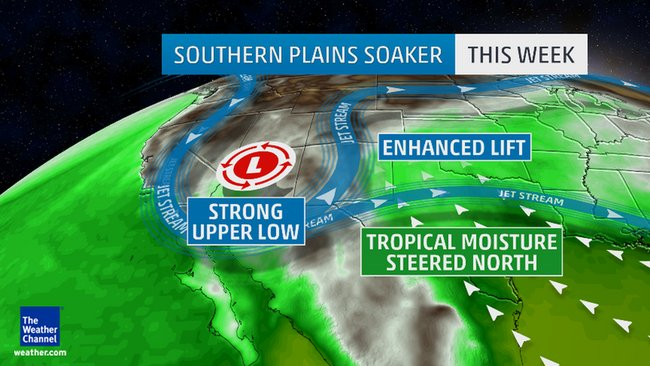
Wonder if we're in an active pattern now. I think that stuck Upper Low kicked started it. Or at least we might be able to say that was the very beginning?
Quote:
Originally Posted by nei
What about me?
Sleep through the whole thing and then pretend your living in a dream when you wake up to snow & cold. All dreams come to an end, right? Lol
Quote:
Originally Posted by chicagogeorge
Typhoon recurving rule.
Saw. Sometimes it doesnt work, sometimes its amazing to see the influences. Is it Koppus doing it? I lost track of all Pacific cyclones.
A CLOSED LOW SLIDING EAST ACROSS THE SOUTHWEST WILL COMBINE WITH RETURN FLOW FROM THE GULF OF MEXICO AND A SLIGHT ERLY TO NERLY UPSLOPE COMPONENT TO PRODUCE WIDESPREAD PRECIPITATION FROM THE SOUTHWEST TO THE PLAINS OVER THE NEXT THREE DAYS. THE MODELS ARE HINTING THAT TEMPERATURE PROFILES COULD BE LOW ENOUGH TO SUPPORT SNOW OVER THE HIGHEST ELEVATIONS OF THE COLORADO ROCKIES.
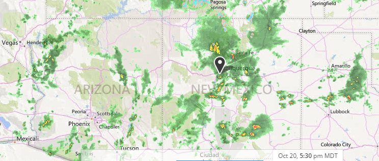
Stormy weather in the southwest and extending into the southern plains.
From TWC:
Quote:
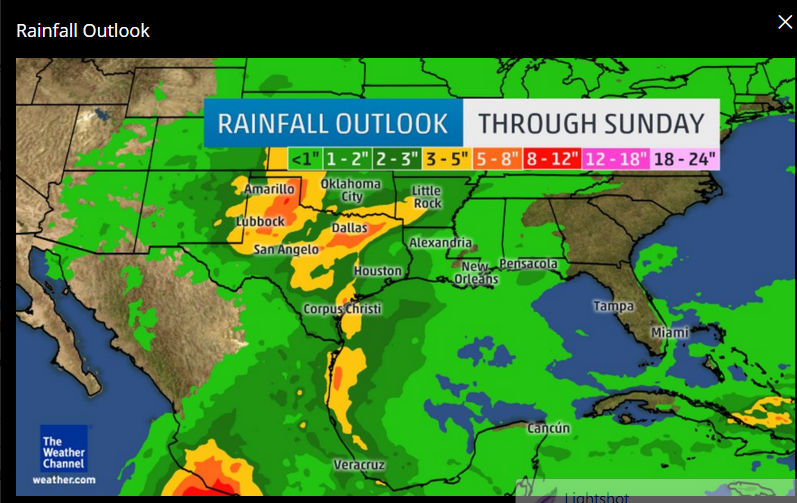
Persistent southeasterly winds will pump moisture from the Gulf of Mexico into the southern High Plains by Wednesday, where it will interact with an area of low pressure forming aloft over the Southwest. This will contribute to heavy rains as far west as eastern New Mexico, western Texas and western Oklahoma by Wednesday night and Thursday.
Did the winds shift as well from morning to afternoon or did they change yesterday or last night?
I didn't pay attention to the wind direction until your mentioning.
Prevailing wind (sorry I'm not an expert so not sure if this is using in right situation) from yesterday through until 9AM today were
mostly blowing from the North and then suddenly change direction to the Southwest. That's a pretty clear reference.
Did the winds shift as well from morning to afternoon or did they change yesterday or last night?
===============
I find it interesting many of us out there are focused on Siberia snow cover, meanwhile, Ontario & Quebec areas in Canada could be getting lots of it..
Now there's a scenario for cold lovers. Imagine that part of Canada stayed with a snowpack from here on out?
if there's a snowpack down during the next cold blast, the cold will go deeper. HMMMMM. Probably why the Euro brings the Polar Jet to northern Gulf states this time.
Right now... who's reporting what. That Hudson Bay must be freezing over fast. Any snow falling on the ice will reflect sunlight even more.
Wow, over a foot in the U.P.! My lowest temperature during the weekend cold snap was 41F. The high on both Sunday and Monday was 72F, a nice change from hot weather.
Please register to post and access all features of our very popular forum. It is free and quick. Over $68,000 in prizes has already been given out to active posters on our forum. Additional giveaways are planned.
Detailed information about all U.S. cities, counties, and zip codes on our site: City-data.com.

 Please register to participate in our discussions with 2 million other members - it's free and quick! Some forums can only be seen by registered members. After you create your account, you'll be able to customize options and access all our 15,000 new posts/day with fewer ads.


 Wonder if we're in an active pattern now. I think that stuck Upper Low kicked started it. Or at least we might be able to say that was the very beginning?