Please register to participate in our discussions with 2 million other members - it's free and quick! Some forums can only be seen by registered members. After you create your account, you'll be able to customize options and access all our 15,000 new posts/day with fewer ads.
Interestingly enough, we only have one day above 90 F in the forecast here. Even a couple of days with highs of 84 F and 85 F.
Yeah, south Atlantic region has the lesser heat anomalies in that map that RAlex posted. I was supposed to hit 90 F today, but have only ended up topping out at 88 F so far. A wedge front is supposed to make it into Georgia/Carolinas by Tuesday while the central US continues to bake.
Yeah, south Atlantic region has the lesser heat anomalies in that map that RAlex posted. I was supposed to hit 90 F today, but have only ended up topping out at 88 F so far. A wedge front is supposed to make it into Georgia/Carolinas by Tuesday while the central US continues to bake.
Yeah, I was looking at the forecast for Raleigh and Greensboro and I saw a lot of low-mid 70s up there. Honestly I think the max RAlex posted is exaggerating a bit with the heat anomalies, at least for the SE coast.
Quote:
Originally Posted by ilovemycomputer90
I think it's going to finally start cooling off.
A couple days in the mid-70s (24 C), but generally around 70 F/21 C and next Saturday is forecast to only be 67 F/19 C.
67 F would be a record low on October 1st here lol.
That's only showing a 60% chance of being above normal for that period. Most likely will be but those maps are just possibilities. I do not see well below normal periods in the East next 2 weeks still. Just keeps going!
Quote:
Originally Posted by alex985
Honestly I think the max RAlex posted is exaggerating a bit with the heat anomalies, at least for the SE coast.
Here's current temp departures. 5pmEDT New England higher than the South
Currently 70F/21C at both Chicago airports and in my suburb under mostly sunny skies.
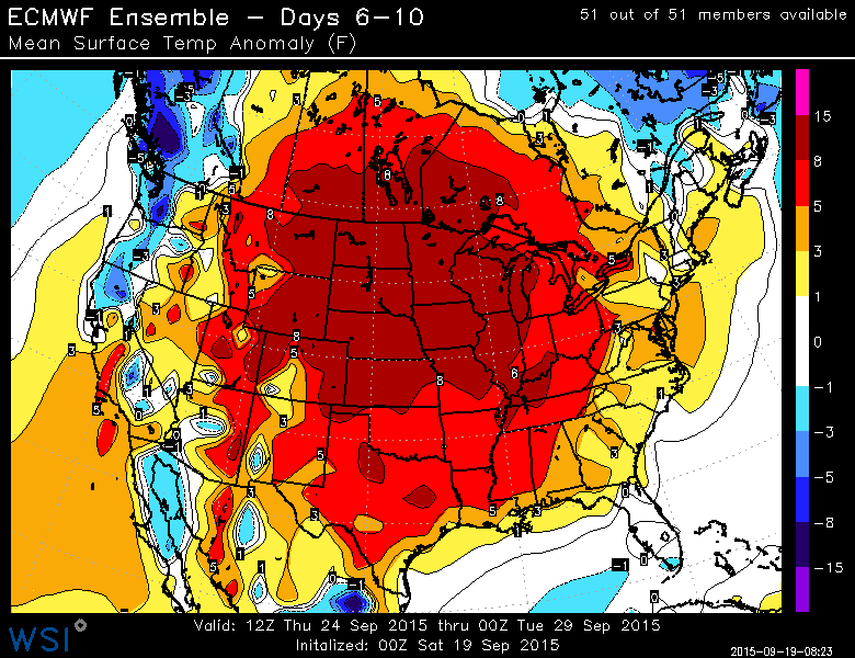
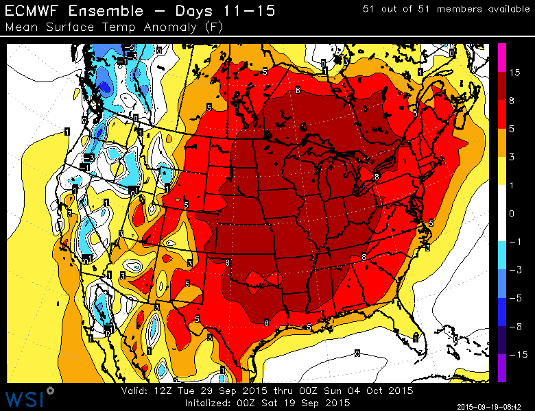
Btw, the Euro is absolutely torching us right into October
It's not going to flip on a dime... you better start praying for normalcy now so we can actually get below normal again for winter. Patterns take months sometimes. This above normal pattern is 5 mths old now but more intense.. Lets hope its the peak.
Quote:
Originally Posted by Cambium
My rule of thumb... when in hot pattern don't believe the cold being shown in the long range until we're within few days of it. Sure enough.. They keep flipping back to warm after showing Fall like temps coming.
And sure enough... AGAIN!!!!!!!!!!!!!!!!!!!!! No more well below normal temps being shown next week..
And this is Euro for Tuesday long Range 29th. Huge High Pressure sitting over this area with 850s in the teens in New England. Poor Upper Mid West. TORCH-O-RAMA-EAST-OF-ROCKIES...and practically no precip
It's not going to flip on a dime... you better start praying for normalcy now so we can actually get below normal again for winter. Patterns take months sometimes. This above normal pattern is 5 mths old now but more intense.. Lets hope its the peak.
For us this above normal pattern has only been around since the end of August. So not even a month.
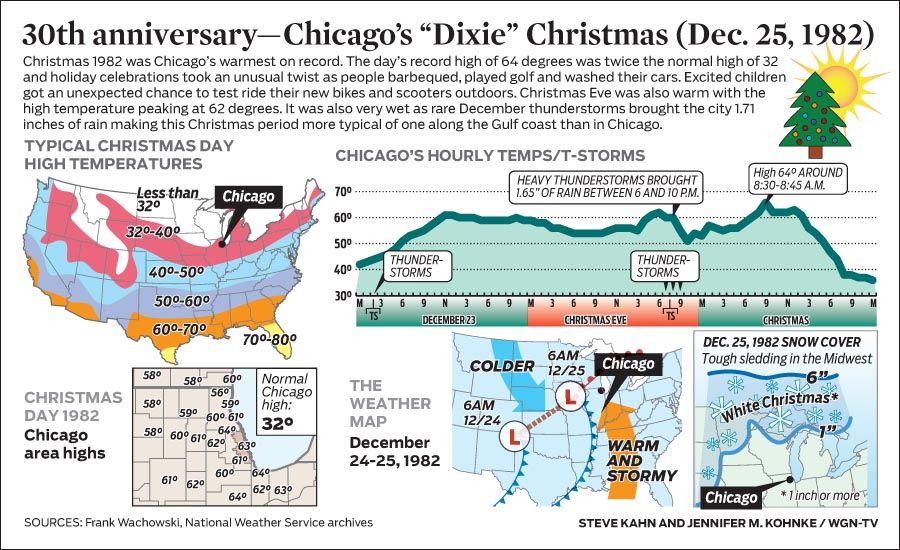
Plus, Bastardi already forecast this winter to be back loaded with most of the cold and snow at the end of January and into February and March, so I'm preparing myself for a "Dixie" Christmas and New Years as was the case during the 82' El Nino. That December we had an average high which would be normal in for Philly.
However sometimes patterns can change on a dime. Check out the summer and fall of 1983, and then look at December.
Please register to post and access all features of our very popular forum. It is free and quick. Over $68,000 in prizes has already been given out to active posters on our forum. Additional giveaways are planned.
Detailed information about all U.S. cities, counties, and zip codes on our site: City-data.com.

 Please register to participate in our discussions with 2 million other members - it's free and quick! Some forums can only be seen by registered members. After you create your account, you'll be able to customize options and access all our 15,000 new posts/day with fewer ads.