Welcome to City-Data.com Forum!
U.S. CitiesCity-Data Forum Index
Go Back   City-Data Forum > General Forums > Weather
 [Register]
Please register to participate in our discussions with 2 million other members - it's free and quick! Some forums can only be seen by registered members. After you create your account, you'll be able to customize options and access all our 15,000 new posts/day with fewer ads.
View detailed profile (Advanced) or search
site with Google Custom Search

Search Forums  (Advanced)
 
Old 03-22-2016, 04:03 PM
 
29,505 posts, read 19,602,720 times
Reputation: 4533

Advertisements

We are at 67 degrees currently....
Reply With Quote Quick reply to this message

 
Old 03-22-2016, 04:09 PM
 
Location: Near the Coast SWCT
83,500 posts, read 75,234,500 times
Reputation: 16619
Quote:
Originally Posted by denverian View Post
I sense your sarcasm lol! Although I'm pretty sure Denver isn't in a blizzard warning - last I heard was about 4" in the city. Yet its 60s and beautiful right now
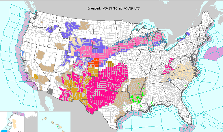
You can have 1 inch of snow fall and still be in a Blizzard Warning. And yeah, looks like Denver is included. Enjoy and stay safe! Wish I was in any of those areas under snow!

http://www.intellicast.com/Storm/Sev....aspx?state=CO

...FAST MOVING STORM EXPECTED TO BRING WINTER WEATHER TO COLORADO
TONIGHT AND WEDNESDAY...

.A FAST MOVING BUT POTENT WINTER STORM SYSTEM WILL MOVE ACROSS
COLORADO TONIGHT AND WEDNESDAY BRINGING SNOW TO THE MOUNTAINS
STARTING THIS EVENING. SNOW AND STRONG WINDS WILL THEN DEVELOP
OVER THE NORTHEAST COLORADO PLAINS ON WEDNESDAY. THE WARM WEATHER
ACROSS NORTHEAST COLORADO TODAY WILL GIVE WAY TO MUCH COLDER
TEMPERATURES ON WEDNESDAY AFTER PASSAGE OF A STRONG COLD FRONT
TONIGHT. RAIN AND SNOW WILL ALSO DEVELOP BEHIND THE COLD FRONT AND
THEN CHANGE TO SNOW IN TIME FOR THE WEDNESDAY MORNING COMMUTE.

STRONG WINDS ARE ALSO EXPECTED TO SPREAD ACROSS THE NORTHEAST
COLORADO PLAINS WHICH WILL CAUSE BLOWING AND DRIFTING SNOW. POOR
TRAVEL CONDITIONS ARE EXPECTED ON THE PLAINS DUE TO THE BLOWING
AND DRIFTING SNOW. ROAD CLOSURES MAY BE POSSIBLE.

COZ040-041-044>046-048>051-231100-
/O.UPG.KBOU.WS.A.0004.160323T1000Z-160324T0000Z/
/O.NEW.KBOU.BZ.W.0001.160323T1000Z-160324T0000Z/
NORTH DOUGLAS COUNTY BELOW 6000 FEET/DENVER/WEST ADAMS AND
ARAPAHOE COUNTIES/EAST BROOMFIELD COUNTY-
ELBERT/CENTRAL AND EAST DOUGLAS COUNTIES ABOVE 6000 FEET-
MORGAN COUNTY-CENTRAL AND EAST ADAMS AND ARAPAHOE COUNTIES-
NORTH AND NORTHEAST ELBERT COUNTY BELOW 6000 FEET/NORTH LINCOLN
COUNTY-LOGAN COUNTY-WASHINGTON COUNTY-SEDGWICK COUNTY-
PHILLIPS COUNTY-
INCLUDING THE CITIES OF...AURORA...BRIGHTON...CITY OF DENVER...

DENVER INTERNATIONAL AIRPORT...HIGHLANDS RANCH...LITTLETON...

PARKER...CASTLE ROCK...ELBERT...FONDIS...KIOWA...LARKSPUR...

BRUSH...FORT MORGAN...GOODRICH...WIGGINS...BENNETT...BYERS...

DEER TRAIL...LEADER...AGATE...HUGO...LIMON...MATHESON.. .CROOK...

MERINO...STERLING...PEETZ...AKRON...COPE...LAST CHANCE...OTIS...

JULESBURG...OVID...SEDGWICK...AMHERST...HAXTUN...H OLYOKE
334 PM MDT TUE MAR 22 2016

THE NATIONAL WEATHER SERVICE IN DENVER HAS ISSUED A BLIZZARD
WARNING...WHICH IS IN EFFECT FROM 4 AM TO 6 PM MDT WEDNESDAY. THE
WINTER STORM WATCH IS NO LONGER IN EFFECT.

* TIMING...THE SNOW AND STRONG WINDS WILL DEVELOP TOWARDS
SUNRISE WEDNESDAY MORNING AND CONTINUE THROUGH THE AFTERNOON.
THE HEAVIEST SNOW AND STRONGEST WINDS ARE EXPECTED FROM MID
MORNING THROUGH EARLY AFTERNOON.

* SNOW ACCUMULATIONS...6 TO 12 INCHES. THE DENVER AREA IS
EXPECTED TO SEE 4 TO 8 INCHES WITH HEAVIEST AMOUNTS AND
STRONGEST WINDS FOUND ACROSS EASTERN PARTS OF THE METRO AREA.

* WIND/VISIBILITY...NORTHWEST WINDS 25 TO 35 MPH WITH GUSTS OF 45
TO 55 MPH POSSIBLE ACROSS THE PLAINS. BLOWING AND DRIFTING SNOW
WILL PRODUCE SNOWPACKED ROADS AND POOR VISIBILITIES.
Reply With Quote Quick reply to this message
 
Old 03-22-2016, 07:13 PM
 
Location: New Jersey
15,318 posts, read 17,212,899 times
Reputation: 6959
Quote:
Originally Posted by Cambium View Post
Blizzard Warnings in Colorado and Winter Warnings out (pink).

Lucky them!

Colorful NWS map tonight!


Winter advisories and warnings pretty much extend from Utah and Idaho to Michigan.

Wind advisories, warnings, and Red Flag Warnings from Arizona to Arkansas.
Reply With Quote Quick reply to this message
 
Old 03-22-2016, 07:17 PM
 
Location: New Jersey
15,318 posts, read 17,212,899 times
Reputation: 6959
Possibility for severe weather tomorrow in Arkansas, Louisiana, Texas, and Oklahoma.


Reply With Quote Quick reply to this message
 
Old 03-22-2016, 08:43 PM
 
29,505 posts, read 19,602,720 times
Reputation: 4533
https://twitter.com/RyanMaue/status/712464504639115264
Reply With Quote Quick reply to this message
 
Old 03-23-2016, 04:39 AM
 
Location: Near the Coast SWCT
83,500 posts, read 75,234,500 times
Reputation: 16619
If Green Bay gets 12" of snow it will be the 1st time on record getting that much in 1 day after March 15th (129yrs of record!)


Problem is, it all wont fall before or after midnight. Should get split up


Reply With Quote Quick reply to this message
 
Old 03-23-2016, 04:57 AM
 
Location: Near the Coast SWCT
83,500 posts, read 75,234,500 times
Reputation: 16619
Quote:
Originally Posted by denverian View Post
I sense your sarcasm lol! Although I'm pretty sure Denver isn't in a blizzard warning - last I heard was about 4" in the city. Yet its 60s and beautiful right now
I noticed you don't post when it snows. I cant say you're another TomFalcons77 because I think you did once or twice. I hope you can post because others are interested in seeing pictures and posts from there as well.


Anyway .. Heavy Snow Discussion out for Denver and area (blue outline). Stay Safe


Current Radar and Temps


Snow total forecast for Colorado


Reply With Quote Quick reply to this message
 
Old 03-23-2016, 06:12 AM
 
Location: Near the Coast SWCT
83,500 posts, read 75,234,500 times
Reputation: 16619
Quote:
Originally Posted by chicagogeorge View Post

Where were you this past winter when it mattered!
Looks like the Polar Vortex comes to visit more this Spring than over winter. Lol. Rather it come in Summer than Spring actually.

3am changeover happened in Denver, now they bunker down as its snowing hard there now.

https://twitter.com/WxTrackerDaryl/s...65833285808130
Reply With Quote Quick reply to this message
 
Old 03-23-2016, 06:54 AM
nei nei won $500 in our forum's Most Engaging Poster Contest - Thirteenth Edition (Jan-Feb 2015). 

Over $104,000 in prizes has already been given out to active posters on our forum and additional contests are planned
 
Location: Western Massachusetts
45,983 posts, read 53,447,987 times
Reputation: 15179
reminder the ECMWF isn't always the best

https://twitter.com/capitalweather/s...19364506177536
Reply With Quote Quick reply to this message
Please register to post and access all features of our very popular forum. It is free and quick. Over $68,000 in prizes has already been given out to active posters on our forum. Additional giveaways are planned.

Detailed information about all U.S. cities, counties, and zip codes on our site: City-data.com.


Reply
Please update this thread with any new information or opinions. This open thread is still read by thousands of people, so we encourage all additional points of view.

Quick Reply
Message:


Over $104,000 in prizes was already given out to active posters on our forum and additional giveaways are planned!

Go Back   City-Data Forum > General Forums > Weather

All times are GMT -6. The time now is 05:03 PM.

© 2005-2024, Advameg, Inc. · Please obey Forum Rules · Terms of Use and Privacy Policy · Bug Bounty

City-Data.com - Contact Us - Archive 1, 2, 3, 4, 5, 6, 7, 8, 9, 10, 11, 12, 13, 14, 15, 16, 17, 18, 19, 20, 21, 22, 23, 24, 25, 26, 27, 28, 29, 30, 31, 32, 33, 34, 35, 36, 37 - Top