Please register to participate in our discussions with 2 million other members - it's free and quick! Some forums can only be seen by registered members. After you create your account, you'll be able to customize options and access all our 15,000 new posts/day with fewer ads.
TEXAS-BEAVER-OCHILTREE-LIPSCOMB-ROBERTS-HEMPHILL-WHEELER-
INCLUDING THE CITIES OF...GUYMON...BEAVER...FORGAN...PERRYTON...
BOOKER...HIGGINS...FOLLETT...MIAMI...CANADIAN...SH AMROCK...
WHEELER
551 AM CST SUN JAN 15 2017
...ICE STORM WARNING REMAINS IN EFFECT UNTIL NOON CST TODAY...
* PRECIP TYPE...EXPECT PERIODS OF LIGHT TO OCCASIONALLY MODERATE
FREEZING RAIN TO CONTINUE THIS MORNING ACROSS THE CENTRAL AND
EASTERN OKLAHOMA PANHANDLE AS WELL AS THE NORTHEAST TEXAS
PANHANDLE.
* ACCUMULATIONS...TOTAL ICE ACCUMULATIONS OF ONE QUARTER TO THREE
QUARTERS OF AN INCH ARE EXPECTED...WITH LOCALLY HIGHER AMOUNTS
POSSIBLE.
* IMPACTS...DRIVING CONDITIONS WILL BECOME NEARLY IMPOSSIBLE.
POWER OUTAGES MAY OCCUR. DAMAGE TO TREES AND POWER LINES IS
POSSIBLE. COMMERCE WILL LIKELY BE IMPACTED. ALSO...ICE ON
SIDEWALKS...PORCHES...AND DRIVEWAYS WILL MAKE WALKING
HAZARDOUS.
HARPER-WOODS-ALFALFA-GRANT-KAY-ELLIS-WOODWARD-MAJOR-ROGER MILLS-
DEWEY-BECKHAM-
INCLUDING THE CITIES OF...BUFFALO...LAVERNE...ALVA...CHEROKEE...
HELENA...CARMEN...MEDFORD...POND CREEK...LAMONT...WAKITA...
PONCA CITY...BLACKWELL...SHATTUCK...ARNETT...GAGE...FARG O...
WOODWARD...FAIRVIEW...CHEYENNE...HAMMON...SEILING. ..VICI...
TALOGA...LEEDEY...ELK CITY...SAYRE
359 AM CST SUN JAN 15 2017
...ICE STORM WARNING REMAINS IN EFFECT UNTIL NOON CST TODAY...
* TIMING...THROUGH NOON TODAY.
* ICE ACCUMULATIONS...ICE ACCUMULATIONS OF ONE QUARTER TO ONE HALF
INCH HAVE OCCURRED WITH ADDITIONAL ACCUMULATIONS LIKELY THIS
MORNING.
* WINDS...NORTHEAST WIND AT 5 TO 10 MPH.
* OTHER IMPACTS...ICE ACCUMULATIONS WILL LIKELY RESULT IN POWER
OUTAGES. BRIDGES... OVERPASSES... AND SECONDARY ROADS MAY
BECOME SLICK AND HAZARDOUS.
Actually just traveling in and of itself isn't that expensive, it's where you stay and what you do at your destination that costs a lot. The trick is to avoid overpriced tourist attractions and just enjoy the location itself.
This, where you stay matters the most. The difference between staying at a $10 hostel vs a $150 four star hotel adds up quickly. People are also more important than the actual destination
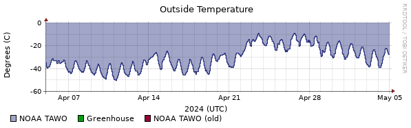
Tbf 2015 started out much earlier, at this point in January it was already mad cold. 2015 also outdid itself by following it up with one of the coldest Marches on record, and a below average April with one of the latest measured snowfalls in Upstate New York. The first 1/3 of 2015 was just nightmarish
Tbf 2015 started out much earlier, at this point in January it was already mad cold. 2015 also outdid itself by following it up with one of the coldest Marches on record, and a below average April with one of the latest measured snowfalls in Upstate New York. The first 1/3 of 2015 was just nightmarish
JB is promising a cold February and March. His analogs for February are 2007, 09', 10', and 15'
This better not disappoint me.... January is turning out to be lame AF here. Haven't seen snow on the ground in a month and counting.. What an ugly scene.
Very wet for the Pacific coast. Also pretty wet in the South.
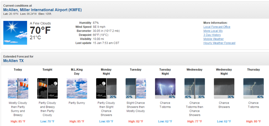
Nothing looks particularly severe here at this time over the next week, but we could get t'storms.
Please register to post and access all features of our very popular forum. It is free and quick. Over $68,000 in prizes has already been given out to active posters on our forum. Additional giveaways are planned.
Detailed information about all U.S. cities, counties, and zip codes on our site: City-data.com.

 Please register to participate in our discussions with 2 million other members - it's free and quick! Some forums can only be seen by registered members. After you create your account, you'll be able to customize options and access all our 15,000 new posts/day with fewer ads.