Please register to participate in our discussions with 2 million other members - it's free and quick! Some forums can only be seen by registered members. After you create your account, you'll be able to customize options and access all our 15,000 new posts/day with fewer ads.
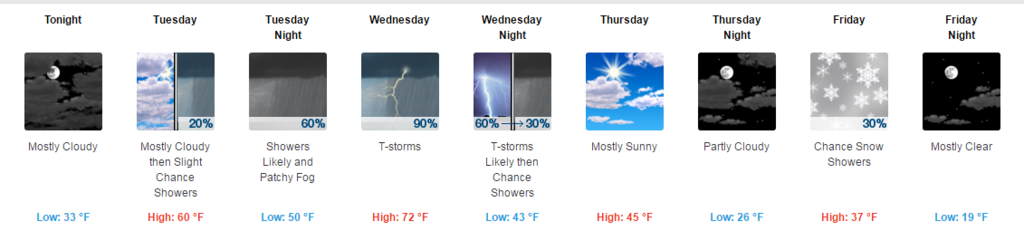
For me Mid 60s and Thunderstorms to Snow and Teens.
Quote:
mild day with high temps on
the high side of MOS guidance, with lower 70s from NYC west and
into the 60s elsewhere. There could be enough instability for
some isold-sct convection from NYC metro west by midday, but the
main push for strong to possibly severe tstms expected late day
into early evening well in advance of the approaching front.
Alberta Clipper low
dropping into the base of the longwave trough that becomes
established over the east for Fri, with the GFS bringing it
right through with a potential light snowfall, and the ECMWF/CMC
taking a more southerly track.
.HYDROLOGY...
Rainfall from this afternoon through Wednesday night should run
from 1/2 to 3/4 of inch, with locally higher amounts possible.
While the possibility is low, stronger convection could cause
isolated minor flooding of poor drainage/urban areas.
No hydrologic impacts expected from any precipitation late this week
through Monday.
Release from spring snow melt is occurring down the Connecticut and Housatonic Rivers.
And here are the record Highs for tomorrow and their forecast high.
Well look at that, in 1972 those areas broke all time record highs. Wonder if they were using the words... "unusual" back than too.
Kinda funny seeing people think all this early warmth is weird.
ITS HAPPENED! EVERYTHING HAS HAPPENED IN THE PAST!! lol
Probably just a marginal severe threat here tomorrow.
Quote:
Some marginal parameters are in place for convection that breaks
through the cap during the afternoon hours could be on the strong
side. Bulk shear from 0-6 km is 50 to 60 knots, although profiles
are mainly uni-directional. 0-3 km and 3-6 km lapse rates are
around 6.5 c/km, and most unstable CAPE values are near 1500 j/kg,
especially during the afternoon hours over northeast and east
portions of the forecast area. Therefore, if storms can get going,
an isolated strong down burst wind gust or hail may occur. The
Storm Prediction Center continues to have areas northeast of a
Leesville to Lafayette line in a Marginal Risk for Severe Weather
in the Day 2 period, that would cover the Wednesday frontal
passage.
Quite warm today, then cooling down to more seasonal temps.
Please register to post and access all features of our very popular forum. It is free and quick. Over $68,000 in prizes has already been given out to active posters on our forum. Additional giveaways are planned.
Detailed information about all U.S. cities, counties, and zip codes on our site: City-data.com.

 Please register to participate in our discussions with 2 million other members - it's free and quick! Some forums can only be seen by registered members. After you create your account, you'll be able to customize options and access all our 15,000 new posts/day with fewer ads.