Please register to participate in our discussions with 2 million other members - it's free and quick! Some forums can only be seen by registered members. After you create your account, you'll be able to customize options and access all our 15,000 new posts/day with fewer ads.
Remember I said watch for the blast around Sept 30th? Well... latest Euro says the blast isn't in the East and we get torched again. I hope its just a bad run otherwise I'll start using #NoFall
Same time frame this is the Jet stream pattern it has. Positive tilted Jet digging over the Rockies. Ridge peaking to Quebec in East. Poor Eastern Alaska in a ridge too.
The biggest difference is that trough in the West. Wasn't there the previous run which allow the cold air to spill more East instead but still wasn't over the Northeast. Each run has been weaker with the cold for Northeast.
Unreal. please be wrong
The heat is locked in pete just like i told ya guys many days ago the high is dead locked in. I am having the hottest weather now vs all summer.
Remember I said watch for the blast around Sept 30th? Well... latest Euro says the blast isn't in the East and we get torched again. I hope its just a bad run otherwise I'll start using #NoFall
Same time frame this is the Jet stream pattern it has. Positive tilted Jet digging over the Rockies. Ridge peaking to Quebec in East. Poor Eastern Alaska in a ridge too.
The biggest difference is that trough in the West. Wasn't there the previous run which allow the cold air to spill more East instead but still wasn't over the Northeast. Each run has been weaker with the cold for Northeast.
Unreal. please be wrong
Not sure how realistic that run looks. Time will tell.
Meanwhile snow has returned to Edmonton. Currently 0°C and snowing. More on the way for the weekend before the warm up: perhaps 5-10cm for parts of central Alberta--more in the mountains.
Quote:
ALBERTA...THE FIRST OF TWO SNOWFALL EVENTS IS CURRENTLY BRINGING SNOW TO CENTRAL ALBERTA. TOTAL ACCUMULATIONS FOR THIS EVENT ARE EXPECTED TO BE 5 CM OR LESS.
RIGHT ON THE HEELS OF THE CURRENT SYSTEM IS A MUCH STRONGER SYSTEM THAT IS EXPECTED TO BRING 5-10 CM OF SNOW TO A WIDE SWATH OF CENTRAL AND SOUTHERN ALBERTA, FROM NORDEGG TO CORONATION. ALSO, OVER THE HIGHER TERRAIN IN BANFF NATIONAL PARK, ICEFIELDS PARKWAY, A FURTHER 15 CM OF SNOW CAN BE EXPECTED BY SATURDAY MORNING AND THUS A SNOWFALL WARNING HAS BEEN ISSUED. ALONG THE RAIN/SNOW LINE FREEZING RAIN IS EXPECTED SATURDAY MORNING FOR AREAS EAST OF CALGARY TOWARDS CORONATION.
SUNDAY, A WARMING TREND BEGINS AND A BREAK FROM AN EARLY START TO WINTER AS TEMPERATURES ARE EXPECTED TO RISE INTO THE DOUBLE DIGITS FOR MOST OF ALBERTA.
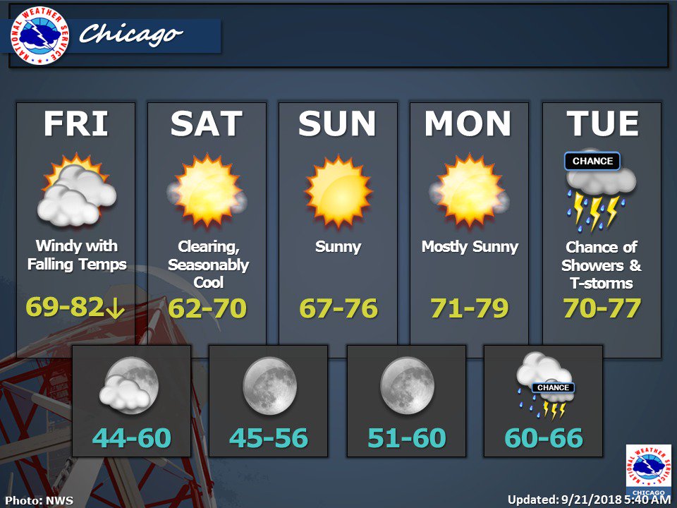
Seems to have been the pattern for the last couple of months that cool downs coincide with weekends. If the models are right we'll have another cool down next weekend. Still negative anomalies throughout.
Source: https://www.theweathernetwork.com/ca...berta/edmonton
Please register to post and access all features of our very popular forum. It is free and quick. Over $68,000 in prizes has already been given out to active posters on our forum. Additional giveaways are planned.
Detailed information about all U.S. cities, counties, and zip codes on our site: City-data.com.

 Please register to participate in our discussions with 2 million other members - it's free and quick! Some forums can only be seen by registered members. After you create your account, you'll be able to customize options and access all our 15,000 new posts/day with fewer ads.


 I hope its just a bad run otherwise I'll start using #NoFall