Please register to participate in our discussions with 2 million other members - it's free and quick! Some forums can only be seen by registered members. After you create your account, you'll be able to customize options and access all our 15,000 new posts/day with fewer ads.
Beautiful thin cirrus clouds today with sun and staying in the 20s.
Quote:
Originally Posted by speagles84
Low was 21F overnight, now 28F and it's SNOWING! Finally
Quote:
Originally Posted by ischyros
Clouds, rain and mid-50s today in Indianapolis..
Is Philly about to get hit with the quickest snow squall ever? Look at that narrow snow band that formed and moving East! Trying to upload a loop by Imgur animation not loading fast enough!
Look at those 60s in sunny Southern West Virginia!
Cloudied up again, What else. 4 hours of sun today at least.
Quote:
Originally Posted by chicagogeorge
No snow on the ground since mid November!
Here and pretty much anywhere north of Mid Atlantic and south of Northern New England too! Crazy! Guess this winter will be known as Front and maybe back loaded?
Snow squall line On Philly's doorstep but look at those dews!
Impressive snow squall line but very dry out there.
10°F in Philly.
10F in Trenton.
4F in Allentown.
-1F in NYC.
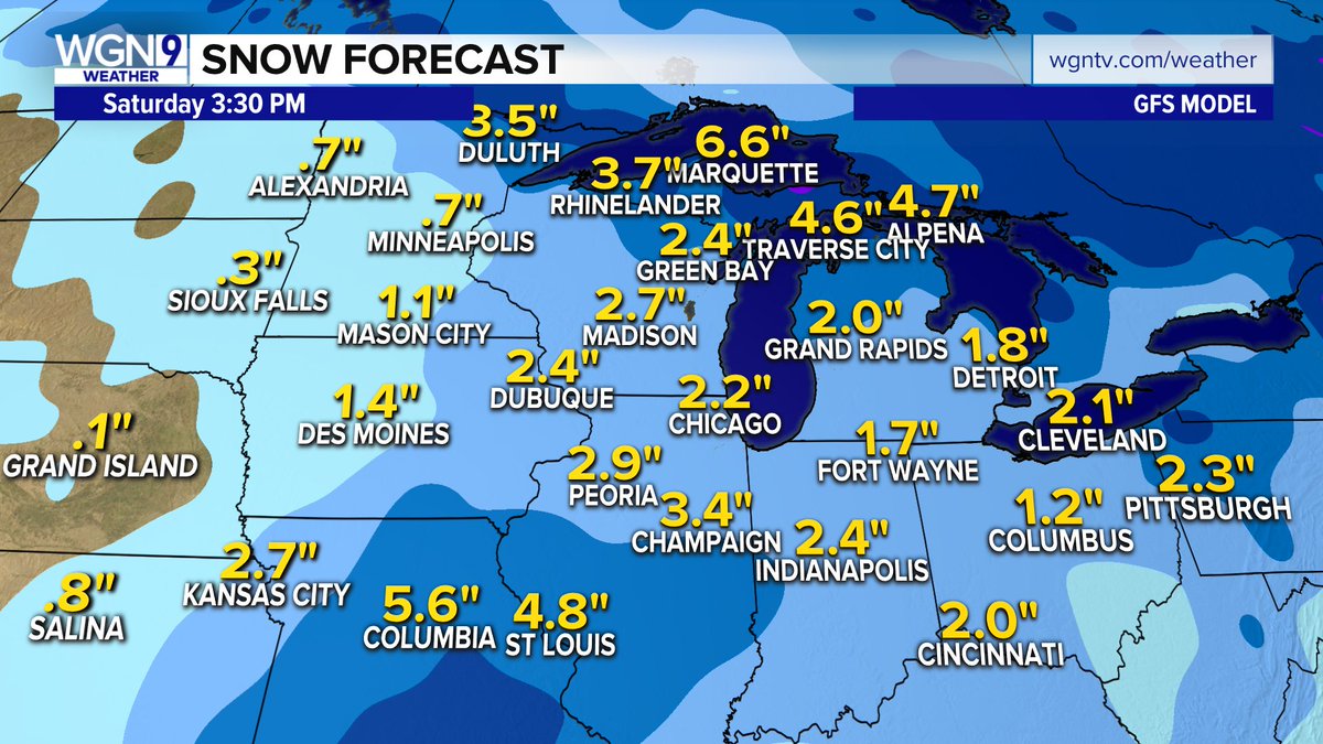
3:25pm map
Mid Level Warm front while surface is cold...but dry
Quote:
Area Forecast Discussion
National Weather Service Mount Holly NJ
334 PM EST Mon Jan 7 2019.
The initial line of snow/sleet that is moving through our
region this afternoon appears to be associated with the mid
level warm front (around 850 to 700 mb). The surface warm front
remains well to our southwest.
This warm front is expected to propagate north into our region
later tonight, aided in part by a low and mid level
southwesterly jet. At the same time, a weak mid and upper level
short wave trough is expected to be lifting east across the
region. The combination of the synoptic scale lift and moisture
advection will result in another brief chance for precipitation
overnight.
As for precipitation type: Dewpoint depressions remain
relatively high, so it may take some time between when the radar
returns first show up and when we actually see precipitation
reaching the ground
In NYC the pattern is:
1. Cold
2. Storm approaching
3. Warming up
4. Rain
5. Cold
Rinse and repeat. Wish #3 would go away so #4 would be snow. Unreal.
Please register to post and access all features of our very popular forum. It is free and quick. Over $68,000 in prizes has already been given out to active posters on our forum. Additional giveaways are planned.
Detailed information about all U.S. cities, counties, and zip codes on our site: City-data.com.

 Please register to participate in our discussions with 2 million other members - it's free and quick! Some forums can only be seen by registered members. After you create your account, you'll be able to customize options and access all our 15,000 new posts/day with fewer ads.