Please register to participate in our discussions with 2 million other members - it's free and quick! Some forums can only be seen by registered members. After you create your account, you'll be able to customize options and access all our 15,000 new posts/day with fewer ads.
A number of weather stations have existed throughout the Andes range of Argentina, but unfortunately most of them have been discontinued or lack long periods of records. However, data is enough to provide valuable information about the climate in very remote areas, which expectedly turns out to be strange.
Which one has the best climate?
From north to south:
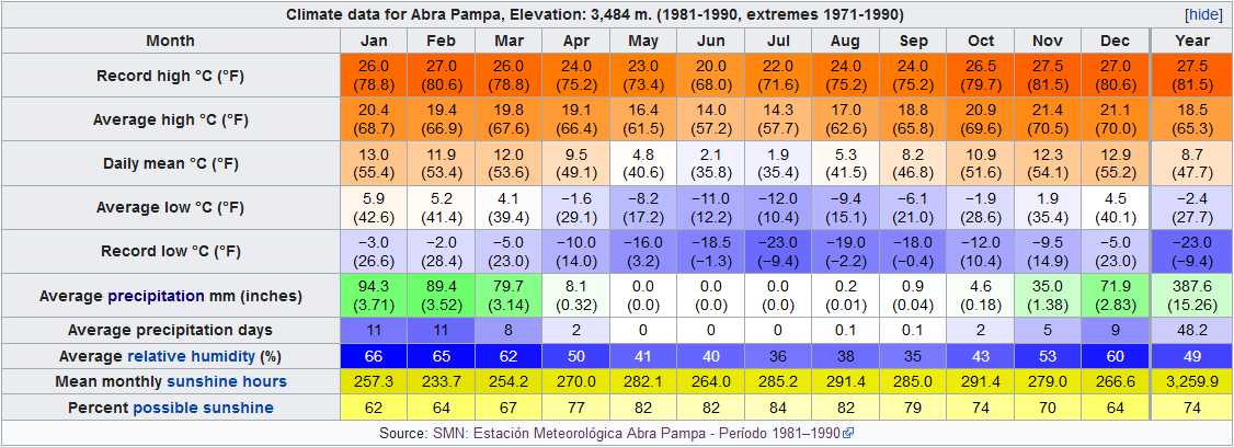
ABRA PAMPA (22°S; 3480 m)
Dry subtropical highland, with stormy summers and very dry winters. Huge diurnal swings. Fairly typical from the Andean Plateau, albeit a bit extreme. https://en.wikipedia.org/wiki/Abra_Pampa#Climate
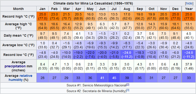
MINA LA CASUALIDAD (25°S; 4050 m)
Alpine tundra or cold desert. Bone dry. Located in the Puna de Atacama, with transitional precipitation regime… if we can say there is any. https://en.wikipedia.org/wiki/Mina_La_Casualidad
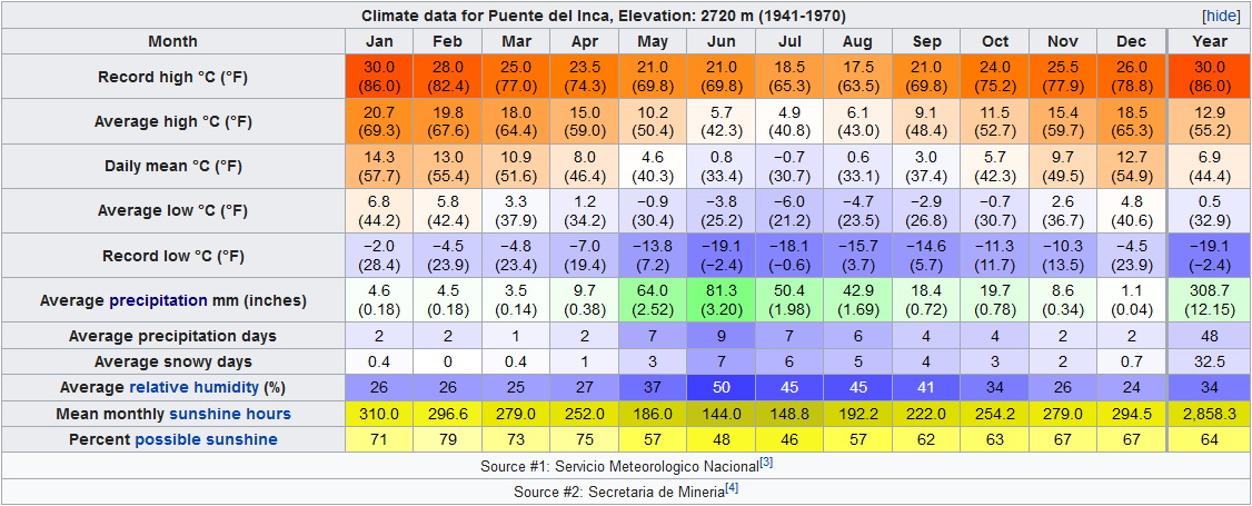
PUENTE DEL INCA (32°S; 2720 m)
Dry Mediterranean Highland, more snowy than the previous one, but subject to constant foehn winds that keep the environment extremely dry. Located in the road that connects Mendoza and Santiago, in the Central Andes of Argentina and Chile. https://en.wikipedia.org/wiki/Puente...hy_and_climate
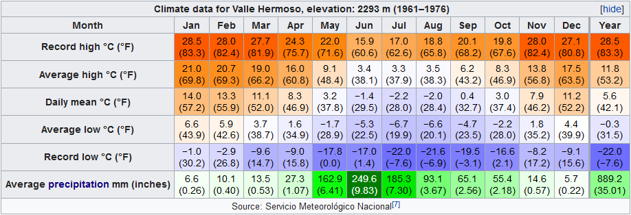
VALLE HERMOSO (35°S; 2290 m)
Mediterranean Highland and considerably wetter than the previous ones, yet the environment looks tundra-like due to the precipitation being overwhelmingly snow. Located near Las Leñas Ski Resort. https://en.wikipedia.org/wiki/Las_Le%C3%B1as#Climate
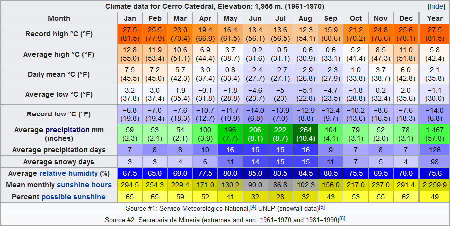
CERRO CATEDRAL (41°S; 1955 m)
Alpine tundra climate. Wet year round, with precipitation maximums in the winter. Ski Center Located in the Bariloche area in northern Patagonia. https://en.wikipedia.org/wiki/Cerro_Catedral#Climate
Valle Hermoso probably would have extrapolated to more recent averages a Dsb (humid continental with dry summer) isotherm climate of 0 °C, with a negative average near this threshold in July. Probably the place in California should have a very similar climate.
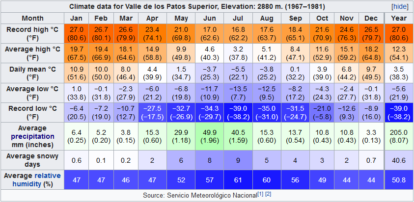
The temperature contrast between Valle de los Patos Superior and Puente del Inca was pretty striking. So was the precipitation increase between 32 S and 35 S.
Valle Hermoso: 48.9% / F+
Cerro Catedral: 44.0% / F
Puente del Inca: 31.2% / F
Valle DLPS: 30.6% / F
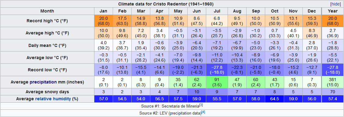
Cristo Redentor: 23.1% / F-
Abra Pampa: 18.3% / Z+
Mina la Casualidad: 1.5% / Z-
Mina loses due to being a desert, Valle Hermoso wins due to relatively warmer summers and more precipitation with a less severe dry season than most.
Cerro Catedral wins this battle for being the wettest climate of all of those climates and frankly it’s abundant annual precipitation is its only redeeming value.
If Argentina were geographically imposed on North America and mirrored North to South it would stretch from Tampico in the east-central part of Mexico all the way to Flin-Flon which straddles Manitoba and Saskatchewan.
Please register to post and access all features of our very popular forum. It is free and quick. Over $68,000 in prizes has already been given out to active posters on our forum. Additional giveaways are planned.
Detailed information about all U.S. cities, counties, and zip codes on our site: City-data.com.

 Please register to participate in our discussions with 2 million other members - it's free and quick! Some forums can only be seen by registered members. After you create your account, you'll be able to customize options and access all our 15,000 new posts/day with fewer ads.