Please register to participate in our discussions with 2 million other members - it's free and quick! Some forums can only be seen by registered members. After you create your account, you'll be able to customize options and access all our 15,000 new posts/day with fewer ads.
Average days of maximum daily temperature over 25°C
Average days of maximum daily temperature over 30°C
Average days of mean daily temperature over 18°C
Average annual sunshine hours
Average overcast days
Average days of strong wind (over 57 km/h)
Average days of fog
Average days of frost
Average snowy days
Average annual rainfall
Average rainy days
Average rainfall intensity
Average rainfall variability
Summer precipitation (mm)
De Martonne summer aridity index
*Formula: Average rainfall in mm/(Average temperture+10)
I have added the website in bookmark quite a while ago, thought it would be great to share on the forum. I decided to create a thread because it's a worthy piece of information to discuss the climate of France and also feel free to compare with other nations in the Western Europe or similar climate zones around the world.
Just one question: What does average rainfall variability mean ?
There are few ways of define the rainfall variability, however judging based on looking the map, seems like they meant how the precipitation pattern distributed throughout the year in average. (Higher value of number = evenly distributed / lower value of number = tend to concentrated in specific season; late autumn to winter most case for southeastern France and coastal areas of Bretagne)
Great. Found the sunniest listed location in the averages table - Marignane.
The closer you get to the Belgian border or La Manche, the average sunshine hours significantly decreases almost half of than location you've mentioned for the sunniest.
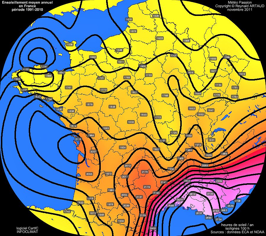
Another map of annual average sunshine hours(20-year period) with contour lines. La Rochelle is the sunniest major city among the Atlantic coast and north of 45°N.
The closer you get to the Belgian border or La Manche, the average sunshine hours significantly decreases almost half of than location you've mentioned for the sunniest.
Another map of annual average sunshine hours(20-year period) with contour lines. La Rochelle is the sunniest major city among the Atlantic coast and north of 45°N.
Very tight gradient in the SE corner of the country. I'd like to hear the reasons for the relatively sunny "bubble" in the middle part of the western coastline ....
I'm guessing this map shows precipitations in mm not per day but per rainy day?
Yes. If the Riviera averaged 4000+ mm / year, the landscape would be lusher, to say the least.
Quote:
Originally Posted by RWood
Very tight gradient in the SE corner of the country. I'd like to hear the reasons for the relatively sunny "bubble" in the middle part of the western coastline ....
It's not really a bubble as one can only assume that it entends over the nearby ocean. It's coastal so sunnier than nearby inland areas to the east, with less summer convection, obviously sunnier than Brittany to its north, but also sunnier than the Basque country to the south and its mountain-induced cloudiness.
Please register to post and access all features of our very popular forum. It is free and quick. Over $68,000 in prizes has already been given out to active posters on our forum. Additional giveaways are planned.
Detailed information about all U.S. cities, counties, and zip codes on our site: City-data.com.

 Please register to participate in our discussions with 2 million other members - it's free and quick! Some forums can only be seen by registered members. After you create your account, you'll be able to customize options and access all our 15,000 new posts/day with fewer ads.