Please register to participate in our discussions with 2 million other members - it's free and quick! Some forums can only be seen by registered members. After you create your account, you'll be able to customize options and access all our 15,000 new posts/day with fewer ads.
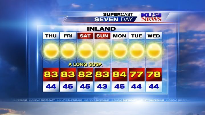
After a relatively chilly and below normal December, January is shaping up to be a pretty warm month. Normal high at the coast this time of year is about 65-66 degrees but it's been above normal since last Fri and will continue to be so for the rest of the week. And "SOSA" means "Sort of Santa Ana", meaning weak Santa Ana winds, the weather guy at this station, John Coleman, is goofy and weird but he apparently started The Weather Channel.
Tonight: Clear, with a low around -12. Wind chill values as low as -30. Northwest wind between 10 and 15 mph.
Thursday: Sunny and cold, with a high near -3. Wind chill values as low as -31. West northwest wind between 10 and 15 mph.
Thursday Night: Mostly clear, with a low around -18. Wind chill values as low as -35. West wind between 10 and 15 mph.
Friday: Mostly sunny and cold, with a high near 6. Wind chill values as low as -34. Southwest wind between 10 and 15 mph.
Friday Night: Snow likely. Mostly cloudy, with a low around 5. Breezy, with a south southwest wind between 10 and 20 mph. Chance of precipitation is 60%.
Saturday: A 30 percent chance of snow. Cloudy and breezy, with a high near 22.
Saturday Night: A 30 percent chance of snow. Mostly cloudy, with a low around 15.
Sunday: A slight chance of snow showers. Partly cloudy, with a high near 24.
Southwest Victoria, Australia Forecast (Temperatures in celsius)
Updated: 4:25pm
Remainder of Friday: Fine though generally cloudy with fresh to strong southerly winds, easing somewhat tonight. Min 12
Saturday: Fine and becoming generally sunny with light winds and a weak afternoon seabreeze. Max 21
Outlook:
Sunday: Fine. Min 10 Max 24
Monday: Mainly fine. Risk late shower or thunderstorm. Min 11 Max 30
Tuesday: Early change - risk thundery shower. Milder. Min 12 Max 24
Wednesday: Fine. Min 12 Max 25
Thursday: Unsettled. Min 10 Max 27
^^^ dude, Snowline and Johnoo thinks that's summer!!!! This a quote from snowline: " It's 21C in Melbourne at midday, I don't really see how that's cold". What a tosser
Crazedmelbweather and The Watto are the only guyz on WZ that have hit the nail on the head.
OH AND OFCOURSE THAT 37C HAS BEEN DOWNGRADED, WHAT A SURPRISE
IT SEEMS PERTH AND SYDNEY AND NOW ADELAIDE ARE GETTING A GREAT SUMMER WHILE WE MISSS OUT AS PER FREAKING USUAL
Yesterday was a fairly cold... temps stayed in the 30's all day (normal high is 52 with a low of 29). A bit warmer for the next few days, to a bit above normal from Saturday through Wednesday. Slightly cooler Thursday.
FORECAST:
Today: Partly sunny, with a high near 47. South wind between 10 and 15 mph.
Tonight: Mostly clear, with a low around 34. South wind between 9 and 15 mph.
Saturday: Sunny, with a high near 62. South wind 9 to 16 mph becoming north northwest.
Saturday Night: Mostly clear, with a low around 32. North northwest wind between 6 and 14 mph.
Sunday: Sunny, with a high near 61. North northwest wind between 8 and 15 mph, with gusts as high as 28 mph.
Sunday Night: Partly cloudy, with a low around 33.
M.L.King Day: Mostly sunny, with a high near 64.
Monday Night: Partly cloudy, with a low around 28.
Tuesday: Mostly sunny, with a high near 64.
Tuesday Night: Mostly clear, with a low around 31.
Wednesday: Sunny, with a high near 65.
Wednesday Night: Mostly clear, with a low around 34.
Thursday: Mostly sunny, with a high near 59.
Please register to post and access all features of our very popular forum. It is free and quick. Over $68,000 in prizes has already been given out to active posters on our forum. Additional giveaways are planned.
Detailed information about all U.S. cities, counties, and zip codes on our site: City-data.com.

 Please register to participate in our discussions with 2 million other members - it's free and quick! Some forums can only be seen by registered members. After you create your account, you'll be able to customize options and access all our 15,000 new posts/day with fewer ads.