Please register to participate in our discussions with 2 million other members - it's free and quick! Some forums can only be seen by registered members. After you create your account, you'll be able to customize options and access all our 15,000 new posts/day with fewer ads.
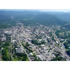
My family and I are staying in Franklin for a week at the end of the month. We'll be in Mountain Air. Since we're not used to really curvy mountainous roads, does anyone know how the drive to that area will be?
We have driven in Asheville, Brevard, Hendersonville, etc before but just don't like drop offs, no guard rail, stuff like that. We were told to avoid 64 between Franklin and Highlands because of that. I know there is a lot in the area, so what are some things we can go see/do without getting on those crazy roads? We like hiking, just nice short ones that aren't too extreme! Thanks!
I mean.... the highways are fine. any road near town is fine. If you want to get out there and hike you will need to drive down some curvy roads. Not a big deal at all. In fact, these are some of the best roads for spirited driving. Ellijay road between Franklin and Cullowhee is very nice for spirited driving. Though I did see some racers wreck once, so be careful.
If you go too slow, you WILL be passed on a double yellow, please dont hold others up. We have to remember that some of us locals here are just trying to get home or go somewhere. Going the speed limit is fine but going 5 under is NOT. We've recently has issues with slow drivers, please be mindful not to loaf around under the limit.
If you are coming to Franklin, youll be on a highway, so youll be fine. The road between Franklin and Highlands can be dangerous because 18 wheelers attempt to drive on it (they are not allowed on the road), they cant take the turns without being in the other lane. Its a serious issue and has caused wrecks. Many folks think it will take someone dying before they do something about it.
The Pickens nose hike is fairly short, You drive on the highway down to Otto NC area, and then on a secondary paved road (no overhangs) and then on a dirt road that goes up the mountain, it does have drop offs and no guardrails, just drive safe, youll be fine. .75 mile from trailhead to the top.
Thanks so much! The main reason I ask is because my dad has had issues with seizures years ago when he was up in high mountains and we think it could be a trigger as it tends to make him uncomfortable so we're trying to avoid areas that wouldn't be good for him... any high areas with drop offs and no guard rails won't be good. And I think Pickens Nose might fall into that category unfortunately! Thank you for the help!
Pickens Nose hike is a good one. Great views! Parking can be a bit tight...
You can also continue past Pickens Nose another mile or so to the trail for the Albert Mountain Fire Tower. That hike is also pretty easy and there is a bit more parking there. You can climb up the fire tower (most of the way) and have some really nice views, too.
Funny story about that place...
During the eclipse last August I had scouted a few locations near the center of the path of totality and ultimately selected Pickens Nose/Albert Mountain Fire Tower as a good location. By the time we arrived - about mid-morning on the day of the eclipse - there must have been 500+ cars parked along that little forest road...from before Picken's Nose all the way to the Fire Tower parking area! It was crazy! We turned around (a miracle itself) and ended up in the Coweeta Lab parking lot - which is just at the beginning of the forest road. That location turned out to be just fine. The drive back to Waynesville was another nightmare, but I couldn't imagine trying to get out after the eclipse from all the way up to Pickens Nose. I'd probably still be driving back...
I was in that same area, I wondered how horrible it would be at pickins..... it was recently slammed labor day weekend. I can only imagine how it was during the eclipse.
For the eclipse, I drove down that other forest road that goes up to little pinnacle. I hike almost every other day in coweta lab area, I know of a lot of places.
I got there and no one was there, unfortunately some guy in a Mercedes SUV showed up but it was still better than being among a mob of people. He only showed up because "I was driving uphill, I knew that was good", dude had no idea where he was.
Perks of being a local I guess, you'd have no idea the place existed unless you've been there before.
Good spot! We didn't have any problems getting out of Coweeta, but once we were on the highway, it was bumper-to-bumper the whole way back to Waynesville.
Please register to post and access all features of our very popular forum. It is free and quick. Over $68,000 in prizes has already been given out to active posters on our forum. Additional giveaways are planned.
Detailed information about all U.S. cities, counties, and zip codes on our site: City-data.com.

 Please register to participate in our discussions with 2 million other members - it's free and quick! Some forums can only be seen by registered members. After you create your account, you'll be able to customize options and access all our 15,000 new posts/day with fewer ads.