Around 5 More Global Maps I Discovered Relevant To More Important World Topics
There is more than hundreds to thousands of global maps existing about regions of the world. There is Visual Image, Summary, and More Surprising Geographic Facts in Maps.
6. Planet Earth Forest Cover, Change in Forest Cover 2000 to 2014, Including Loss, and Gain
I expected more of the world to have very lush forests in nature. Maybe there was much more forest cover in the past before millions and billions of people in human settlement. However, there is some trees vegetation in areas not in lush forest characterization label. Global Map of Forest Cover is more about not interrupted areas of very lush forests, and somewhat of a strict qualification.
There is 888,000 square miles (2.3 million square km) of lost disappearing forest in 2000-2014 while there is 309,000 square miles (800,000 sq. km) of gained forest that actually recovered and came back into existence.
Deforestation rates of forest loss is worst in Russia, Indonesia, and Canada based on a global map. There is improvement in protection of forests in Brazil, including less deforestation compared to around a decade ago, and forest gains in regions of Southern Brazil. Ironically, there is some actual forest gains in areas of China where nobody expects and not too much deforestation occurring over there!

*A More Close Up Image Shown In
Global Forest Change | Google Crisis Map
7. Internet Penetration World Map, Percentage of a National Population Reliance and Dependence On Internet
Highest Internet Penetration is in Scandinavia, some of Benelux, and Australia around 90% to 100% of national population have Internet.
A majority of countries actually don’t have 90% to 100% Internet penetration yet, and there is continuing growth of modern development in technological innovation of Internet Online. When people start using relevant forms of technology more, they feel Internet is essential and important in personal entertainment, and daily life functioning.
Norway, Sweden, Australia, Netherlands, Denmark, Finland, New Zealand, Switzerland, UK, Germany, South Korea, Canada, Belgium, Japan, Brunei, Slovakia, USA, Estonia, France, Singapore, Austria, Slovenia, Czech Republic, UAE, Israel, Hong Kong, and Taiwan all have more than 70% of National Population frequently using Internet.
Internet 50 Countries with Highest Penetration Rates - Internet World Stats
Some countries that have less than 10% to 20% of national population using Internet are Congo, Haiti, Honduras, Nicaragua, Bangladesh, Cambodia, Madagascar, Iraq, Afghanistan, Sierra Leone, and Botswana. Some dirt poor African countries have only 1% of entire population with Internet. Eritrea has the lowest Internet penetration for any country in the world with only 0.8% of national inhabitants that have Internet.

8. Digital Opportunity Index Based On Information Age, TeleCommunications, and How People Involve Digital Forms of Technology In Everyday Life
There is usually a correlation towards countries that are economically wealthy, have very high Online Internet Penetration, technologically savvy, modern forms of prominent development, and a high percentage of national inhabitants with knowledge and talent in science, technology, and more professional occupations.
A Top 25 Countries List include South Korea, Japan, Denmark, Iceland, Singapore, Netherlands, Taiwan, Hong Kong, Sweden, UK, Finland, Norway, Israel, Switzerland, Canada, Austria, Germany, USA, Spain, Australia, and Belgium.
 Digital Opportunity Index (DOI)
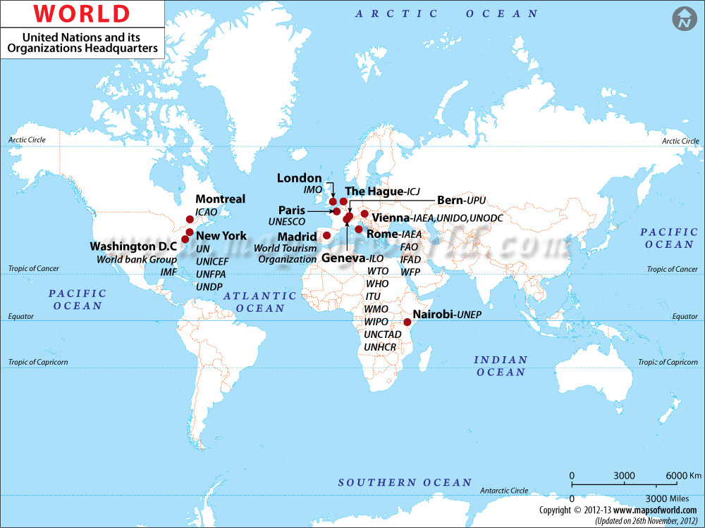
9. United Nations Affiliated Organizations and Headquarters
There is currently a highest amount of United Nations headquarters in Geneva Switzerland. All specific organizations in each city:
Geneva Switzerland: United Nations Conference on Trade and Development, International Telecommunication Union, International Labor Organization, High Commissioner for Refugees, World Health Organization, World Intellectual Property Organization, World Meteorological Organization, and World Trade Organization Paris France: United Nations Educational, Scientific, and Cultural Organization Vienna Austria: International Energy Agency, United Nations Industrial Development Organization, United Nations Office on Drugs and Crime The Hague Netherlands: International Court of Justice Rome Italy: International Fund for Agricultural Development, World Food Programme, Food and Agriculture Organization London UK: Maritime Organization Madrid Spain: World Tourism Organization Montreal Canada: International Civil Aviation Organization Washington DC: International Monetary Fund New York City USA: United Nations, Children’s Fund, Population Fund Nairobi Kenya: United Nations Environment Programme
Why isn’t there any United Nations headquarters in Asia, Oceania, and South America? That doesn’t make any rational sense, just like how United Nations somehow categorizes Taiwan in China, and not a separate country yet.
There is too much emphasis of United Nations Organizational Headquarters in Europe, and North America. Some international organization headquarters is especially arbitrary with Rome, and Nairobi.
10. Global Observation of User Generated Photos On World Wide Web Internet Online
A Map showing amount of Photos taken in specific regions and areas of the World, Volume of Images.
Maybe there is too much popularity of photos taken in Europe, especially in Northern Italy, and Benelux? Eastern and Southern coastal provinces of China, Taiwan, southern areas of Vietnam, South Korea, central Japan, Java island of Indonesia, and Kerala India are highest photographed areas of Asia.


 Please register to participate in our discussions with 2 million other members - it's free and quick! Some forums can only be seen by registered members. After you create your account, you'll be able to customize options and access all our 15,000 new posts/day with fewer ads.


