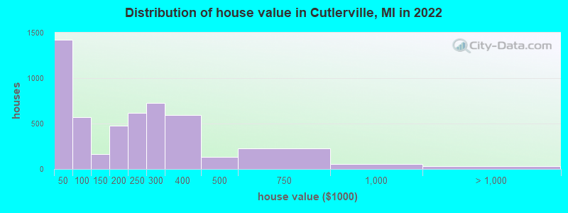
Estimated median house or condo value in 2022: $217,692 (it was $75,200 in 2000)
Cutlerville:
$217,692
MI:
$224,400
Mean prices in 2022:all housing units: $177,843; detached houses: $253,400; townhouses or other attached units: $231,857; in 3-to-4-unit structures: $213,332; in 5-or-more-unit structures: $105,479; mobile homes: $26,118
Median gross rent in 2022: $1,179.
March 2022 cost of living index in Cutlerville: 86.0 (less than average, U.S. average is 100)
Percentage of residents living in poverty in 2022: 12.5%
(7.7% for White Non-Hispanic residents, 31.8% for Black residents, 21.0% for Hispanic or Latino residents, 20.2% for American Indian residents, 14.5% for other race residents, 10.2% for two or more races residents)
According to our research of Michigan and other state lists, there was 1 registered sex offender living in Cutlerville, Michigan as of April 25, 2024. The ratio of all residents to sex offenders in Cutlerville is 15,692 to 1. The ratio of registered sex offenders to all residents in this city is much lower than the state average.
Recent articles from our blog. Our writers, many of them Ph.D. graduates or candidates, create easy-to-read articles on a wide variety of topics.
Latest news from Cutlerville, MI collected exclusively by city-data.com from local newspapers, TV, and radio stations
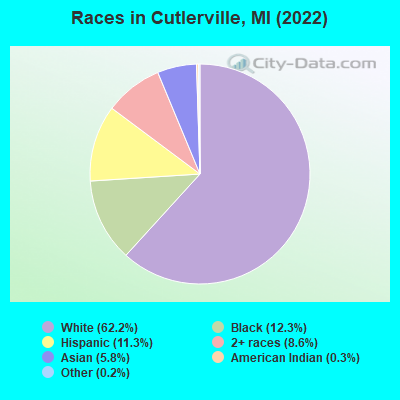
Ancestries: Dutch (17.5%), German (8.6%), English (7.6%), American (7.5%), African (3.7%), Irish (2.6%).
Current Local Time: EST time zone
Elevation: 678 feet
Land area: 5.98 square miles.
Population density: 2,403 people per square mile (low).
1,562 residents are foreign born (3.7% Asia, 1.9% Africa, 1.8% Latin America).
This place:
8.1%
Michigan:
6.9%
Median real estate property taxes paid for housing units with mortgages in 2022: $2,598 (1.0%) Median real estate property taxes paid for housing units with no mortgage in 2022: $1,933 (1.3%)
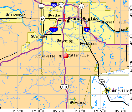
Nearest city with pop. 50,000+: Wyoming, MI (4.6 miles , pop. 69,368).
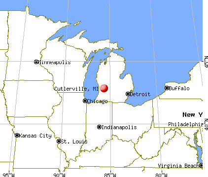
Nearest city with pop. 200,000+: Milwaukee, WI (116.9 miles , pop. 596,974).
Nearest city with pop. 1,000,000+: Chicago, IL (123.9 miles , pop. 2,896,016).
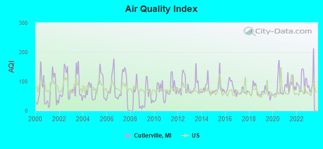
Air Quality Index (AQI) level in 2022 was 97.7. This is worse than average.
City:
97.7
U.S.:
72.6
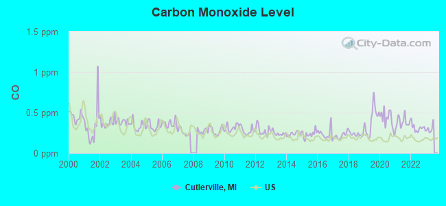
Carbon Monoxide (CO) [ppm] level in 2022 was 0.310. This is worse than average.Closest monitor was 9.5 miles away from the city center.
City:
0.310
U.S.:
0.251
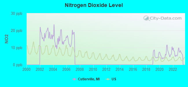
Nitrogen Dioxide (NO2) [ppb] level in 2022 was 7.01. This is worse than average.Closest monitor was 8.7 miles away from the city center.
City:
7.01
U.S.:
5.11
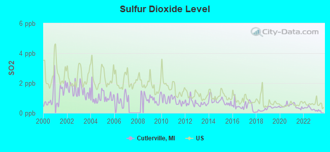
Sulfur Dioxide (SO2) [ppb] level in 2022 was 0.321. This is significantly better than average.Closest monitor was 8.7 miles away from the city center.
City:
0.321
U.S.:
1.515
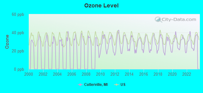
Ozone [ppb] level in 2022 was 29.0. This is about average.Closest monitor was 9.5 miles away from the city center.
City:
29.0
U.S.:
33.3
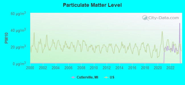
Particulate Matter (PM10) [µg/m3] level in 2022 was 17.2. This is about average.Closest monitor was 8.2 miles away from the city center.
City:
17.2
U.S.:
19.2
Particulate Matter (PM2.5) [µg/m3] level in 2022 was 9.03. This is about average.Closest monitor was 8.2 miles away from the city center.
City:
9.03
U.S.:
8.11
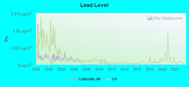
Lead (Pb) [µg/m3] level in 2010 was 0.00613. This is significantly better than average.Closest monitor was 4.3 miles away from the city center.
City:
0.00613
U.S.:
0.00931
Tornado activity:
Cutlerville-area historical tornado activity is slightly above Michigan state average. It is 11% greater than the overall U.S. average.
On 4/3/1956, a category F5 (max. wind speeds 261-318 mph) tornado 30.5 miles away from the Cutlerville place center killed 18 peopleand injured 340 peopleand causedbetween $50,000 and $500,000 in damages.
On 4/11/1965, a category F4 (max. wind speeds 207-260 mph) tornado 18.0 miles away from the place center killed 5 peopleand injured 142 peopleand causedbetween $500,000 and $5,000,000 in damages.
Earthquake activity:
Cutlerville-area historical earthquake activity is significantly above Michigan state average. It is 24% smaller than the overall U.S. average.
On 5/2/2015 at 16:23:07, a magnitude 4.2 (4.2 MW, Depth: 2.8 mi, Class: Light, Intensity: IV - V) earthquake occurred 43.4 miles away from Cutlerville center On 1/31/1986 at 16:46:43, a magnitude 5.0 (5.0 MB, Class: Moderate, Intensity: VI - VII) earthquake occurred 246.1 miles away from the city center On 9/25/1998 at 19:52:52, a magnitude 5.2 (4.8 MB, 4.3 MS, 5.2 LG, 4.5 MW, Depth: 3.1 mi) earthquake occurred 285.7 miles away from the city center On 4/18/2008 at 09:36:59, a magnitude 5.4 (5.1 MB, 4.8 MS, 5.4 MW, 5.2 MW) earthquake occurred 324.9 miles away from the city center On 7/12/1986 at 08:19:37, a magnitude 4.5 (4.5 MB) earthquake occurred 172.6 miles away from the city center On 6/10/1987 at 23:48:54, a magnitude 5.1 (4.9 MB, 4.4 MS, 4.6 MS, 5.1 LG) earthquake occurred 301.1 miles away from Cutlerville center Magnitude types: regional Lg-wave magnitude (LG), body-wave magnitude (MB), surface-wave magnitude (MS), moment magnitude (MW)
Natural disasters:
The number of natural disasters in Kent County (11) is smaller than the US average (15). Major Disasters (Presidential) Declared: 6 Emergencies Declared: 4
Causes of natural disasters: Storms: 5, Floods: 4, Tornadoes: 3, Winter Storms: 2, Blizzard: 1, Hurricane: 1, Snowstorm: 1, Wind: 1, Other: 1 (Note: some incidents may be assigned to more than one category).
Hospitals and medical centers near Cutlerville:
RENAL ADVANTAGE - CLYDE PARK (Dialysis Facility, about 3 miles away; WYOMING, MI)
HEARTLAND HEALTH CARE CENTER-CRESTVIEW (Nursing Home, about 5 miles away; WYOMING, MI)
SPECTRUM HEALTH HOSPICE (Hospital, about 5 miles away; GRAND RAPIDS, MI)
HOLLAND HOME - BRETON REHABILITATION LIVING CENTRE (Nursing Home, about 5 miles away; GRAND RAPIDS, MI)
CARE ONE HOME HEALTH SERVICES, INC (Home Health Center, about 5 miles away; WYOMING, MI)
COMMUNITY CARE GIVERS (Home Health Center, about 7 miles away; GRANDVILLE, MI)
LUTHER HOME (Nursing Home, about 7 miles away; GRAND RAPIDS, MI)
Amtrak station near Cutlerville:
9 miles: GRAND RAPIDS (MARKET & WEALTHY STS.) . Services: enclosed waiting area, public restrooms, public payphones, free short-term parking, free long-term parking, call for taxi service, public transit connection.
Colleges/universities with over 2000 students nearest to Cutlerville:
Davenport University (about 7 miles; Grand Rapids, MI; Full-time enrollment: 6,955)
Calvin College (about 8 miles; Grand Rapids, MI; FT enrollment: 4,117)
Grand Rapids Community College (about 9 miles; Grand Rapids, MI; FT enrollment: 11,296)
Cornerstone University (about 11 miles; Grand Rapids, MI; FT enrollment: 2,573)
Grand Valley State University (about 15 miles; Allendale, MI; FT enrollment: 21,982)
Hope College (about 23 miles; Holland, MI; FT enrollment: 3,535)
Western Michigan University (about 39 miles; Kalamazoo, MI; FT enrollment: 20,840)
User-submitted facts and corrections:
Byron Hills Golf Course went out of business. The West 9 was replaced by a housing development 2 years ago. The East 18 has also been replaced by a housing development, starting last summer. added by Jayeddie
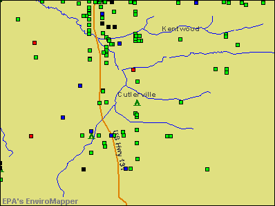
Churches in Cutlerville include: Discovery Church (A), Covenant Christian Reformed Church (B), Cutlerville East Christian Church (C), Good News Community Church (D), Grandville Christian Fellowship (E), First Cutlerville Christian Church (F), Banner of Christ Community Church (G). Display/hide their locations on the map
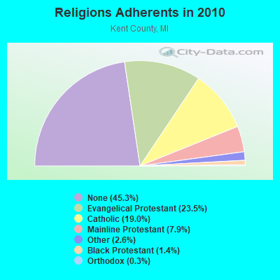
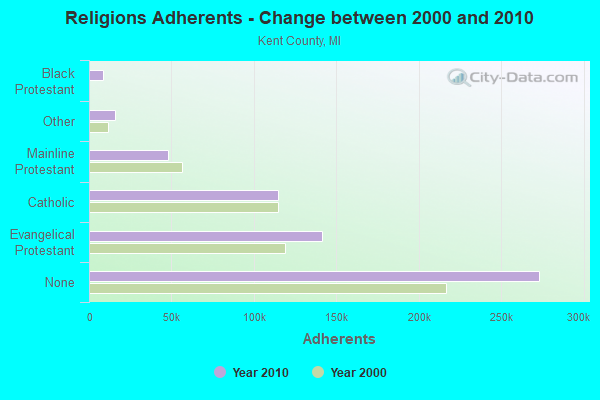
Religion statistics for Cutlerville, MI (based on Kent County data)
Religion
Adherents
Congregations
Evangelical Protestant
141,345
354
Catholic
114,437
37
Mainline Protestant
47,892
117
Other
15,674
41
Black Protestant
8,454
11
Orthodox
1,730
6
None
273,090
-
Source: Clifford Grammich, Kirk Hadaway, Richard Houseal, Dale E.Jones, Alexei Krindatch, Richie Stanley and Richard H.Taylor. 2012. 2010 U.S.Religion Census: Religious Congregations & Membership Study. Association of Statisticians of American Religious Bodies. Jones, Dale E., et al. 2002. Congregations and Membership in the United States 2000. Nashville, TN: Glenmary Research Center. Graphs represent county-level data
CUTLERVILLE, 7545 Clay Ave. (Lat: 42.845389 Lon: -85.674333), Type: Pole, Structure height: 47.2 m, Call Sign: WQLL970, Assigned Frequencies: 11325.0 MHz, 11525.0 MHz, Grant Date: 02/04/2020, Expiration Date: 03/04/2030, Cancellation Date: 09/26/2022, Certifier: Gregory M Romano, Registrant: Verizon, 1300 I St Nw - Suite 500 East, Washington, DC 20005, Phone: (202) 515-2453, Email:
FCC Registered Amateur Radio Licenses:
1
Call Sign: N8NCM, Licensee ID: L00330771, Grant Date: 02/28/2011, Expiration Date: 05/28/2021, Cancellation Date: 05/31/2023, Certifier: Tim E Lomas, Registrant: Tim E Lomas, 7485 Sunview Se, Cutlerville, MI 49548
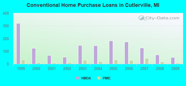
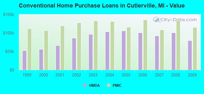
Home Mortgage Disclosure Act Aggregated Statistics For Year 2009 (Based on 3 full and 1 partial tracts)
A) FHA, FSA/RHS & VA Home Purchase Loans
B) Conventional Home Purchase Loans
C) Refinancings
D) Home Improvement Loans
F) Non-occupant Loans on < 5 Family Dwellings (A B C & D)
G) Loans On Manufactured Home Dwelling (A B C & D)
Number
Average Value
Number
Average Value
Number
Average Value
Number
Average Value
Number
Average Value
Number
Average Value
LOANS ORIGINATED
34
$109,576
51
$79,322
153
$126,111
10
$31,441
3
$83,047
20
$34,404
APPLICATIONS APPROVED, NOT ACCEPTED
2
$73,300
18
$34,554
19
$109,618
1
$120,000
0
$0
16
$28,086
APPLICATIONS DENIED
6
$108,085
7
$43,186
40
$128,281
6
$12,590
1
$11,980
5
$29,586
APPLICATIONS WITHDRAWN
12
$104,158
5
$100,036
26
$122,319
2
$51,605
1
$99,350
1
$12,980
FILES CLOSED FOR INCOMPLETENESS
0
$0
1
$39,000
9
$107,131
1
$23,610
0
$0
0
$0
Aggregated Statistics For Year 2008 (Based on 3 full and 1 partial tracts)
A) FHA, FSA/RHS & VA Home Purchase Loans
B) Conventional Home Purchase Loans
C) Refinancings
D) Home Improvement Loans
E) Loans on Dwellings For 5+ Families
F) Non-occupant Loans on < 5 Family Dwellings (A B C & D)
G) Loans On Manufactured Home Dwelling (A B C & D)
Number
Average Value
Number
Average Value
Number
Average Value
Number
Average Value
Number
Average Value
Number
Average Value
Number
Average Value
LOANS ORIGINATED
29
$120,180
72
$100,881
74
$121,263
15
$30,331
2
$1,565,990
8
$89,072
26
$30,534
APPLICATIONS APPROVED, NOT ACCEPTED
1
$113,230
26
$51,606
9
$117,814
0
$0
0
$0
0
$0
22
$32,727
APPLICATIONS DENIED
4
$111,512
25
$52,303
64
$124,482
19
$23,308
0
$0
0
$0
18
$24,876
APPLICATIONS WITHDRAWN
1
$153,140
7
$101,759
32
$132,562
1
$100,220
0
$0
4
$122,735
2
$43,430
FILES CLOSED FOR INCOMPLETENESS
0
$0
4
$90,235
5
$142,678
1
$10,000
0
$0
1
$106,780
0
$0
Aggregated Statistics For Year 2007 (Based on 3 full and 1 partial tracts)
A) FHA, FSA/RHS & VA Home Purchase Loans
B) Conventional Home Purchase Loans
C) Refinancings
D) Home Improvement Loans
E) Loans on Dwellings For 5+ Families
F) Non-occupant Loans on < 5 Family Dwellings (A B C & D)
G) Loans On Manufactured Home Dwelling (A B C & D)
Number
Average Value
Number
Average Value
Number
Average Value
Number
Average Value
Number
Average Value
Number
Average Value
Number
Average Value
LOANS ORIGINATED
5
$139,346
127
$92,001
96
$173,914
15
$37,456
3
$3,109,103
14
$85,725
23
$312,661
APPLICATIONS APPROVED, NOT ACCEPTED
0
$0
23
$66,885
19
$120,798
2
$34,950
0
$0
4
$87,545
14
$46,007
APPLICATIONS DENIED
4
$173,542
39
$74,081
109
$105,802
10
$18,654
0
$0
7
$123,034
18
$33,156
APPLICATIONS WITHDRAWN
2
$84,415
17
$93,831
21
$118,790
2
$48,675
0
$0
3
$126,120
3
$21,310
FILES CLOSED FOR INCOMPLETENESS
0
$0
2
$125,930
9
$115,636
0
$0
0
$0
1
$132,000
0
$0
Aggregated Statistics For Year 2006 (Based on 3 full and 1 partial tracts)
A) FHA, FSA/RHS & VA Home Purchase Loans
B) Conventional Home Purchase Loans
C) Refinancings
D) Home Improvement Loans
E) Loans on Dwellings For 5+ Families
F) Non-occupant Loans on < 5 Family Dwellings (A B C & D)
G) Loans On Manufactured Home Dwelling (A B C & D)
Number
Average Value
Number
Average Value
Number
Average Value
Number
Average Value
Number
Average Value
Number
Average Value
Number
Average Value
LOANS ORIGINATED
13
$126,193
174
$101,262
118
$99,822
22
$29,441
1
$529,000
8
$112,570
19
$21,877
APPLICATIONS APPROVED, NOT ACCEPTED
0
$0
25
$84,332
17
$115,019
4
$32,508
0
$0
1
$96,040
7
$13,550
APPLICATIONS DENIED
3
$107,493
49
$61,989
85
$105,014
25
$23,293
1
$8,990
7
$107,944
23
$22,114
APPLICATIONS WITHDRAWN
2
$160,560
21
$90,059
45
$118,559
4
$21,130
0
$0
4
$115,480
2
$49,420
FILES CLOSED FOR INCOMPLETENESS
1
$138,000
7
$100,346
17
$129,151
1
$29,690
0
$0
0
$0
0
$0
Aggregated Statistics For Year 2005 (Based on 3 full and 1 partial tracts)
A) FHA, FSA/RHS & VA Home Purchase Loans
B) Conventional Home Purchase Loans
C) Refinancings
D) Home Improvement Loans
E) Loans on Dwellings For 5+ Families
F) Non-occupant Loans on < 5 Family Dwellings (A B C & D)
G) Loans On Manufactured Home Dwelling (A B C & D)
Number
Average Value
Number
Average Value
Number
Average Value
Number
Average Value
Number
Average Value
Number
Average Value
Number
Average Value
LOANS ORIGINATED
10
$101,450
182
$106,067
160
$117,293
33
$32,122
2
$1,108,480
19
$106,216
16
$24,671
APPLICATIONS APPROVED, NOT ACCEPTED
1
$143,000
19
$67,841
27
$107,112
1
$15,000
0
$0
0
$0
6
$23,148
APPLICATIONS DENIED
11
$74,233
83
$66,358
107
$117,356
29
$39,333
0
$0
14
$134,994
55
$25,139
APPLICATIONS WITHDRAWN
0
$0
23
$96,007
72
$130,634
6
$40,835
0
$0
2
$136,905
0
$0
FILES CLOSED FOR INCOMPLETENESS
0
$0
12
$54,904
21
$117,445
2
$59,910
0
$0
0
$0
3
$5,990
Aggregated Statistics For Year 2004 (Based on 3 full and 1 partial tracts)
A) FHA, FSA/RHS & VA Home Purchase Loans
B) Conventional Home Purchase Loans
C) Refinancings
D) Home Improvement Loans
F) Non-occupant Loans on < 5 Family Dwellings (A B C & D)
G) Loans On Manufactured Home Dwelling (A B C & D)
Number
Average Value
Number
Average Value
Number
Average Value
Number
Average Value
Number
Average Value
Number
Average Value
LOANS ORIGINATED
14
$122,459
145
$103,774
194
$112,842
24
$31,695
23
$122,482
25
$19,827
APPLICATIONS APPROVED, NOT ACCEPTED
0
$0
20
$69,298
32
$100,289
4
$29,450
3
$146,620
12
$27,817
APPLICATIONS DENIED
4
$123,852
58
$55,040
113
$99,075
30
$19,430
7
$78,770
49
$22,829
APPLICATIONS WITHDRAWN
2
$118,435
8
$116,938
38
$131,629
4
$45,420
0
$0
2
$47,450
FILES CLOSED FOR INCOMPLETENESS
2
$128,920
8
$64,731
38
$128,662
2
$24,530
1
$112,820
5
$23,362
Aggregated Statistics For Year 2003 (Based on 3 full and 1 partial tracts)
A) FHA, FSA/RHS & VA Home Purchase Loans
B) Conventional Home Purchase Loans
C) Refinancings
D) Home Improvement Loans
F) Non-occupant Loans on < 5 Family Dwellings (A B C & D)
Number
Average Value
Number
Average Value
Number
Average Value
Number
Average Value
Number
Average Value
LOANS ORIGINATED
12
$122,878
146
$97,028
528
$103,366
24
$22,133
29
$90,573
APPLICATIONS APPROVED, NOT ACCEPTED
0
$0
21
$77,157
51
$100,523
3
$25,320
3
$99,510
APPLICATIONS DENIED
3
$110,007
89
$31,673
143
$80,626
24
$16,598
9
$69,271
APPLICATIONS WITHDRAWN
3
$112,290
12
$110,634
62
$102,654
0
$0
4
$100,892
FILES CLOSED FOR INCOMPLETENESS
2
$81,935
5
$137,970
14
$127,461
1
$90,510
0
$0
Aggregated Statistics For Year 2002 (Based on 1 full and 1 partial tracts)
A) FHA, FSA/RHS & VA Home Purchase Loans
B) Conventional Home Purchase Loans
C) Refinancings
D) Home Improvement Loans
F) Non-occupant Loans on < 5 Family Dwellings (A B C & D)
Number
Average Value
Number
Average Value
Number
Average Value
Number
Average Value
Number
Average Value
LOANS ORIGINATED
4
$91,252
55
$86,300
153
$106,162
10
$20,670
12
$98,827
APPLICATIONS APPROVED, NOT ACCEPTED
0
$0
12
$36,495
18
$94,056
2
$8,075
1
$8,990
APPLICATIONS DENIED
1
$61,900
60
$27,268
38
$66,310
13
$7,770
3
$80,690
APPLICATIONS WITHDRAWN
0
$0
6
$70,785
18
$125,661
0
$0
0
$0
FILES CLOSED FOR INCOMPLETENESS
0
$0
1
$327,480
14
$102,366
0
$0
1
$57,910
Aggregated Statistics For Year 2001 (Based on 1 full and 1 partial tracts)
A) FHA, FSA/RHS & VA Home Purchase Loans
B) Conventional Home Purchase Loans
C) Refinancings
D) Home Improvement Loans
F) Non-occupant Loans on < 5 Family Dwellings (A B C & D)
Number
Average Value
Number
Average Value
Number
Average Value
Number
Average Value
Number
Average Value
LOANS ORIGINATED
7
$111,347
67
$66,163
113
$104,663
12
$17,202
8
$111,876
APPLICATIONS APPROVED, NOT ACCEPTED
0
$0
30
$33,470
11
$70,186
4
$34,025
1
$214,870
APPLICATIONS DENIED
0
$0
151
$27,465
42
$72,357
22
$6,425
20
$39,986
APPLICATIONS WITHDRAWN
1
$132,790
3
$65,093
11
$93,594
2
$31,085
0
$0
FILES CLOSED FOR INCOMPLETENESS
0
$0
0
$0
3
$97,237
0
$0
0
$0
Aggregated Statistics For Year 2000 (Based on 1 full and 1 partial tracts)
A) FHA, FSA/RHS & VA Home Purchase Loans
B) Conventional Home Purchase Loans
C) Refinancings
D) Home Improvement Loans
E) Loans on Dwellings For 5+ Families
F) Non-occupant Loans on < 5 Family Dwellings (A B C & D)
Number
Average Value
Number
Average Value
Number
Average Value
Number
Average Value
Number
Average Value
Number
Average Value
LOANS ORIGINATED
3
$90,477
125
$55,615
31
$58,890
18
$14,661
2
$1,670,820
10
$61,154
APPLICATIONS APPROVED, NOT ACCEPTED
1
$125,800
52
$40,312
10
$42,992
4
$18,118
0
$0
7
$49,777
APPLICATIONS DENIED
0
$0
221
$26,934
35
$39,095
19
$6,717
0
$0
9
$12,758
APPLICATIONS WITHDRAWN
0
$0
4
$49,415
6
$78,243
0
$0
0
$0
0
$0
FILES CLOSED FOR INCOMPLETENESS
0
$0
0
$0
2
$85,790
0
$0
0
$0
0
$0
Aggregated Statistics For Year 1999 (Based on 2 full and 1 partial tracts)
A) FHA, FSA/RHS & VA Home Purchase Loans
B) Conventional Home Purchase Loans
C) Refinancings
D) Home Improvement Loans
F) Non-occupant Loans on < 5 Family Dwellings (A B C & D)
#55 on the list of "Top 101 cities with the largest percentage of people in residential treatment centers for emotionally disturbed children (population 1,000+)"
#68 on the list of "Top 101 cities with the most residents born in Bosnia and Herzegovina (population 500+)"
#97 on the list of "Top 101 cities with the largest percentage of people in hospitals or wards for drug/alcohol abuse (population 1,000+)"
#20 (49508) on the list of "Top 101 zip codes with the largest percentage of Dutch first ancestries (pop 5,000+)"
#16 on the list of "Top 101 counties with the highest carbon monoxide air pollution readings in 2012 (ppm)"
#39 on the list of "Top 101 counties with the largest decrease in the number of infant deaths per 1000 residents 2000-2006 to 2007-2013 (pop. 50,000+)"
#46 on the list of "Top 101 counties with the lowest Particulate Matter (PM10) Annual air pollution readings in 2012 (µg/m3)"
#48 on the list of "Top 101 counties with the most Evangelical Protestant adherents"
#53 on the list of "Top 101 counties with the highest percentage of residents that visited a dentist within the past year"


 Recent articles from our blog. Our writers, many of them Ph.D. graduates or candidates, create easy-to-read articles on a wide variety of topics.


 (4.6 miles