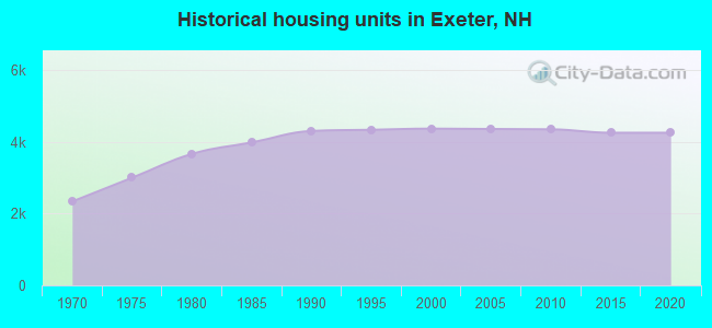
Estimated median house or condo value in 2022: $362,233 (it was $126,600 in 2000)
Exeter:
$362,233
NH:
$384,700
Mean prices in 2022:all housing units: $394,211; detached houses: $541,602; townhouses or other attached units: $470,281; in 2-unit structures: $577,229; in 3-to-4-unit structures: $841,569; in 5-or-more-unit structures: $189,971; mobile homes: $76,424
Median gross rent in 2022: $1,491.
March 2022 cost of living index in Exeter: 133.3 (high, U.S. average is 100)
According to our research of New Hampshire and other state lists, there were 10 registered sex offenders living in Exeter, New Hampshire as of April 18, 2024. The ratio of all residents to sex offenders in Exeter is 907 to 1. The ratio of registered sex offenders to all residents in this city is lower than the state average.
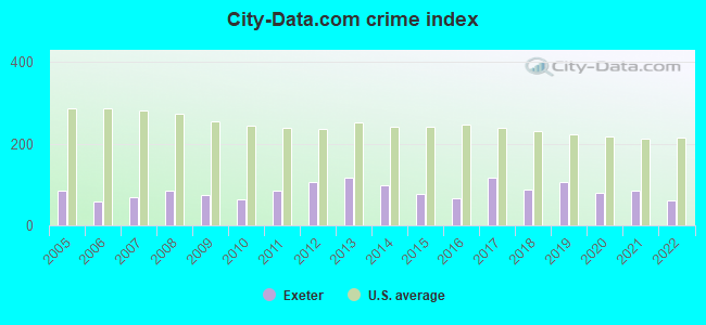
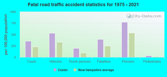
Crime rates in Exeter by year
Type
2009
2010
2011
2012
2013
2014
2015
2016
2017
2018
2019
2020
2021
2022
Murders (per 100,000)
0 (0.0)
1 (7.0)
0 (0.0)
0 (0.0)
1 (6.9)
0 (0.0)
1 (6.8)
0 (0.0)
0 (0.0)
1 (6.5)
0 (0.0)
0 (0.0)
0 (0.0)
0 (0.0)
Rapes (per 100,000)
5 (33.7)
1 (7.0)
4 (27.9)
8 (55.6)
8 (55.2)
8 (54.8)
4 (27.4)
5 (34.2)
11 (74.3)
6 (39.2)
10 (64.8)
8 (51.8)
8 (51.3)
5 (31.0)
Robberies (per 100,000)
0 (0.0)
0 (0.0)
1 (7.0)
1 (7.0)
3 (20.7)
5 (34.2)
2 (13.7)
0 (0.0)
5 (33.8)
2 (13.1)
0 (0.0)
0 (0.0)
2 (12.8)
1 (6.2)
Assaults (per 100,000)
3 (20.2)
2 (14.0)
10 (69.8)
7 (48.7)
10 (69.0)
6 (41.1)
7 (47.9)
7 (47.8)
13 (87.8)
7 (45.7)
19 (123.2)
9 (58.3)
13 (83.4)
7 (43.3)
Burglaries (per 100,000)
17 (114.6)
22 (153.8)
26 (181.5)
19 (132.1)
13 (89.7)
18 (123.2)
14 (95.8)
14 (95.7)
8 (54.0)
6 (39.2)
11 (71.3)
5 (32.4)
6 (38.5)
4 (24.8)
Thefts (per 100,000)
123 (829.0)
106 (740.9)
118 (823.7)
129 (897.1)
112 (773.1)
95 (650.4)
68 (465.2)
81 (553.5)
83 (560.5)
104 (679.5)
86 (557.5)
85 (550.2)
74 (474.5)
80 (495.2)
Auto thefts (per 100,000)
6 (40.4)
1 (7.0)
4 (27.9)
7 (48.7)
1 (6.9)
3 (20.5)
3 (20.5)
2 (13.7)
8 (54.0)
2 (13.1)
3 (19.4)
6 (38.8)
5 (32.1)
10 (61.9)
Arson (per 100,000)
1 (6.7)
1 (7.0)
2 (14.0)
5 (34.8)
0 (0.0)
1 (6.8)
0 (0.0)
0 (0.0)
0 (0.0)
1 (6.5)
0 (0.0)
1 (6.5)
0 (0.0)
0 (0.0)
City-Data.com crime index
75.4
63.3
86.3
105.4
115.8
98.6
76.2
66.8
117.6
88.5
105.3
80.5
85.8
61.8
The City-Data.com crime index weighs serious crimes and violent crimes more heavily. Higher means more crime, U.S. average is 246.1. It adjusts for the number of visitors and daily workers commuting into cities.
Latest news from Exeter, NH collected exclusively by city-data.com from local newspapers, TV, and radio stations
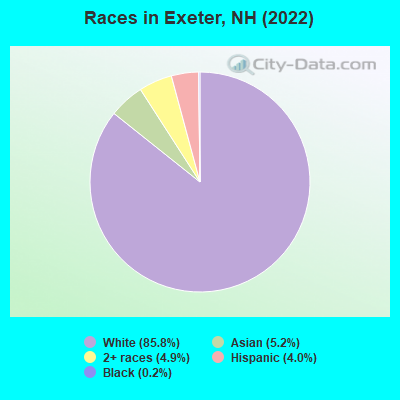
Ancestries: Irish (12.5%), English (11.0%), French Canadian (7.1%), American (6.4%), Italian (5.8%), German (5.4%).
Current Local Time: EST time zone
Incorporated in 1638
Elevation: 45 feet
Land area: 4.38 square miles.
Population density: 2,112 people per square mile (low).
613 residents are foreign born (3.1% Asia, 2.4% Europe).
This place:
6.1%
New Hampshire:
6.0%
Median real estate property taxes paid for housing units with mortgages in 2022: $7,546 (1.6%) Median real estate property taxes paid for housing units with no mortgage in 2022: $5,049 (2.6%)
Nearest city with pop. 50,000+: Haverhill, MA (15.3 miles , pop. 58,969).
Nearest city with pop. 200,000+: Boston, MA (45.9 miles , pop. 589,141).
Nearest city with pop. 1,000,000+: Bronx, NY (210.5 miles , pop. 1,332,650).
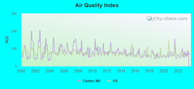
Air Quality Index (AQI) level in 2022 was 65.2. This is about average.
City:
65.2
U.S.:
72.6
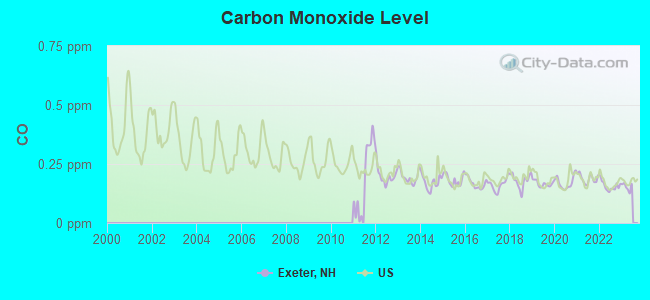
Carbon Monoxide (CO) [ppm] level in 2022 was 0.157. This is significantly better than average.Closest monitor was 11.9 miles away from the city center.
City:
0.157
U.S.:
0.251
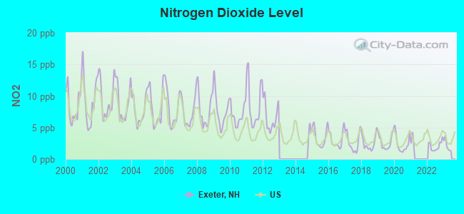
Nitrogen Dioxide (NO2) [ppb] level in 2022 was 2.05. This is significantly better than average.Closest monitor was 11.0 miles away from the city center.
City:
2.05
U.S.:
5.11
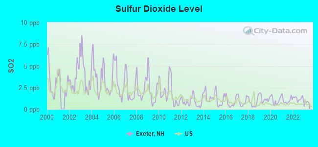
Sulfur Dioxide (SO2) [ppb] level in 2022 was 1.23. This is better than average.Closest monitor was 11.0 miles away from the city center.
City:
1.23
U.S.:
1.51
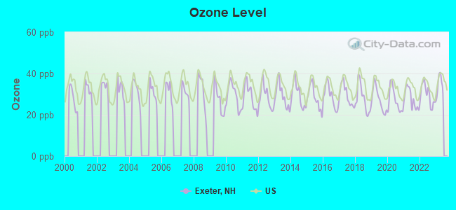
Ozone [ppb] level in 2022 was 29.7. This is about average.Closest monitor was 10.6 miles away from the city center.
City:
29.7
U.S.:
33.3
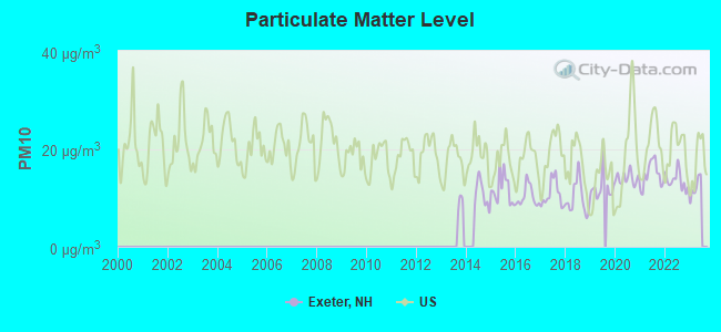
Particulate Matter (PM10) [µg/m3] level in 2022 was 13.5. This is significantly better than average.Closest monitor was 11.9 miles away from the city center.
City:
13.5
U.S.:
19.2
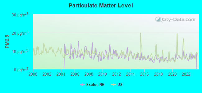
Particulate Matter (PM2.5) [µg/m3] level in 2022 was 6.46. This is better than average.Closest monitor was 11.9 miles away from the city center.
City:
6.46
U.S.:
8.11
Tornado activity:
Exeter-area historical tornado activity is near New Hampshire state average. It is 51% smaller than the overall U.S. average.
On 6/9/1953, a category F3 (max. wind speeds 158-206 mph) tornado 1.0 miles away from the Exeter place center injured 5 peopleand causedbetween $5000 and $50,000 in damages.
On 9/29/1974, a category F3 tornado 27.7 miles away from the place center injured one personand causedbetween $50,000 and $500,000 in damages.
Earthquake activity:
Exeter-area historical earthquake activity is significantly above New Hampshire state average. It is 73% smaller than the overall U.S. average.
On 10/16/2012 at 23:12:25, a magnitude 4.7 (4.7 ML, Depth: 10.0 mi, Class: Light, Intensity: IV - V) earthquake occurred 45.4 miles away from Exeter center On 4/20/2002 at 10:50:47, a magnitude 5.3 (5.3 ML, Depth: 3.0 mi, Class: Moderate, Intensity: VI - VII) earthquake occurred 173.4 miles away from the city center On 1/19/1982 at 00:14:42, a magnitude 4.7 (4.5 MB, 4.7 MD, 4.5 LG) earthquake occurred 48.7 miles away from the city center On 10/7/1983 at 10:18:46, a magnitude 5.3 (5.1 MB, 5.3 LG, 5.1 ML) earthquake occurred 183.0 miles away from the city center On 4/20/2002 at 10:50:47, a magnitude 5.2 (5.2 MB, 4.2 MS, 5.2 MW, 5.0 MW) earthquake occurred 173.2 miles away from Exeter center On 8/22/1992 at 12:20:32, a magnitude 4.8 (4.8 MB, 3.8 MS, 4.7 LG, Depth: 6.2 mi) earthquake occurred 269.8 miles away from the city center Magnitude types: regional Lg-wave magnitude (LG), body-wave magnitude (MB), duration magnitude (MD), local magnitude (ML), surface-wave magnitude (MS), moment magnitude (MW)
Natural disasters:
The number of natural disasters in Rockingham County (26) is a lot greater than the US average (15). Major Disasters (Presidential) Declared: 17 Emergencies Declared: 9
Causes of natural disasters: Storms: 12, Floods: 9, Winter Storms: 5, Hurricanes: 4, Snowstorms: 4, Snows: 2, Winds: 2, Blizzard: 1, Snowfall: 1, Tornado: 1 (Note: some incidents may be assigned to more than one category).
Main business address for: BENTLEY PHARMACEUTICALS INC (PHARMACEUTICAL PREPARATIONS).
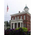
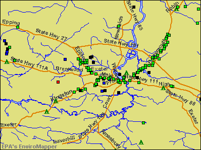
Notable locations in Exeter: Exeter Country Club (A), Exeter Fire Department (B), American Independence Museum (C), American Independence Museum Library (D), Exeter Town Hall (E), Exeter Area Chamber of Commerce (F), Gilman Garrison House (G), Giddinges Tavern (H). Display/hide their locations on the map
Churches in Exeter include: Faith Lutheran Church (A), Calvary Baptist Church (B), Exeter Presbyterian Church (C), First Congregational Church (D), First Baptist Church of Exeter (E), Christ Episcopal Church (F). Display/hide their locations on the map
Streams, rivers, and creeks: Exeter River (A), Parkman Brook (B), Norris Brook (C), Little River (D), Dearborn Brook (E). Display/hide their locations on the map
Parks in Exeter include: Gilman Park (1), Front Street Historic District (2), Exeter Waterfront Commercial Historic District (3), Phillips Exeter Academy Stadium (4). Display/hide their locations on the map
Tourist attraction: Exeter Historical Society (Museums; 47 Front Street).
Hotels: Inn by the Bandstand (4 Front Street), Exeter Inn (90 Front Street).
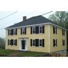
Birthplace of: Dan Brown - Author, Dudley Leavitt (publisher) - Teacher, John Irving - (born 1942), A Prayer for Owen Meany and The Cider House Rules, Daniel Chester French - Artist, Lewis Cass - Politician, Nicholas Gilman - Politician, Ambrose Swasey - Engineer, Chad Eaton - 2005 NFL player (Dallas Cowboys, born: Apr 6, 1972), Chris Carpenter - 2005 Major League Baseball player (St. Louis Cardinals, born: Apr 27, 1975), Granville Hicks - Socialist.
Rockingham County has a predicted average indoor radon screening level between 2 and 4 pCi/L (pico curies per liter) - Moderate Potential
Drinking water stations with addresses in Exeter and their reported violations in the past:
EXETER WATER DEPT (Address: 13 NEWFIELDS RD , Population served: 11,000, Surface water):
Past health violations:
MCL, Average - Between JAN-2012 and MAR-2012, Contaminant: Arsenic. Follow-up actions: St Public Notif requested (FEB-10-2012), St Violation/Reminder Notice (FEB-10-2012), St Public Notif received (MAR-02-2012), St Compliance achieved (SEP-11-2012)
MCL, Average - Between JAN-2011 and MAR-2011, Contaminant: TTHM. Follow-up actions: St Public Notif requested (APR-26-2011), St Violation/Reminder Notice (APR-26-2011), St Public Notif received (JUN-02-2011), St Compliance achieved (FEB-09-2012)
MCL, Average - Between OCT-2010 and DEC-2010, Contaminant: TTHM. Follow-up actions: St Public Notif received (DEC-23-2010), St Formal NOV issued (JAN-26-2011), St Compliance achieved (FEB-09-2012)
MCL, Average - Between JUL-2010 and SEP-2010, Contaminant: TTHM. Follow-up actions: St Public Notif requested (NOV-10-2010), St Violation/Reminder Notice (NOV-10-2010), St Public Notif received (DEC-23-2010), St Formal NOV issued (JAN-26-2011), St Compliance achieved (FEB-09-2012)
MCL, Average - Between JUL-2007 and SEP-2007, Contaminant: Arsenic. Follow-up actions: St Public Notif requested (OCT-01-2007), St Violation/Reminder Notice (OCT-01-2007), St Public Notif received (NOV-05-2007), St Compliance achieved (AUG-18-2009)
MCL, Average - Between APR-2007 and JUN-2007, Contaminant: Arsenic. Follow-up actions: St Public Notif requested (JUL-11-2007), St Violation/Reminder Notice (JUL-11-2007), St Public Notif received (JUL-30-2007), St Compliance achieved (AUG-18-2009)
Past monitoring violations:
Single Turbidity Exceed (Enhanced SWTR) - Between DEC-01-2006 and JAN-01-2007, Contaminant: IESWTR. Follow-up actions: St Public Notif received (JAN-16-2007), St Public Notif requested (JAN-30-2007), St Violation/Reminder Notice (JAN-30-2007), St Compliance achieved (JUN-07-2007)
Monthly Turbidity Exceed (Enhanced SWTR) - Between NOV-01-2006 and DEC-01-2006, Contaminant: IESWTR. Follow-up actions: St Public Notif requested (JAN-09-2007), St Violation/Reminder Notice (JAN-09-2007), St Public Notif received (JAN-16-2007), St Compliance achieved (JUN-07-2007)
Single Turbidity Exceed (Enhanced SWTR) - Between NOV-01-2006 and DEC-01-2006, Contaminant: IESWTR. Follow-up actions: St Public Notif requested (JAN-09-2007), St Violation/Reminder Notice (JAN-09-2007), St Public Notif received (JAN-16-2007), St Compliance achieved (JUN-07-2007)
Monitoring, Turbidity (Enhanced SWTR) - Between JUL-01-2006 and AUG-01-2006, Contaminant: IESWTR. Follow-up actions: St Public Notif received (SEP-05-2006), St Public Notif requested (SEP-08-2006), St Violation/Reminder Notice (SEP-08-2006), St Compliance achieved (JUN-07-2007)
Single Turbidity Exceed (Enhanced SWTR) - Between JUL-01-2006 and AUG-01-2006, Contaminant: IESWTR. Follow-up actions: St Public Notif received (SEP-05-2006), St Public Notif requested (SEP-08-2006), St Violation/Reminder Notice (SEP-08-2006), St Compliance achieved (JUN-07-2007)
3 other older monitoring violations
EXETER RIVER MOBILE HOME PARK (Population served: 980, Purch surface water):
Past health violations:
MCL, Acute (TCR) - In AUG-2011, Contaminant: Coliform. Follow-up actions: St Public Notif received (AUG-29-2011), St Public Notif requested (AUG-31-2011), St Violation/Reminder Notice (AUG-31-2011), St Compliance achieved (MAR-19-2012)
MCL, Average - Between OCT-2008 and DEC-2008, Contaminant: Di(2-ethylhexyl) phthalate. Follow-up actions: St Public Notif requested (FEB-03-2009), St Violation/Reminder Notice (FEB-03-2009), St Public Notif received (MAR-23-2009), St Compliance achieved (JUL-09-2009)
Past monitoring violations:
Lead Consumer Notice - In JUL-01-2012, Contaminant: Lead and Copper Rule. Follow-up actions: St Violation/Reminder Notice (JUL-10-2012), St Compliance achieved (JUL-19-2012)
One routine major monitoring violation
One minor monitoring violation
2 regular monitoring violations
PINELAND PARK (Population served: 425, Groundwater):
Past monitoring violations:
Failure To Address Deficiency - In JAN-19-2014, Contaminant: GROUNDWATER RULE. Follow-up actions: St Public Notif requested (JAN-22-2014), St Violation/Reminder Notice (JAN-22-2014), St Public Notif received (FEB-13-2014), St Compliance achieved (APR-21-2014)
EXETER RIVER LANDING (Population served: 380, Groundwater):
Past monitoring violations:
Failure To Address Deficiency - In JUL-10-2013, Contaminant: GROUNDWATER RULE. Follow-up actions: St Public Notif requested (JUL-30-2013), St Formal NOV issued (JUL-30-2013), St Public Notif received (SEP-05-2013), St AO (w/o penalty) issued (APR-15-2014)
Failure To Address Deficiency - In APR-02-2012, Contaminant: GROUNDWATER RULE. Follow-up actions: St Compliance achieved (APR-11-2012), St Violation/Reminder Notice (APR-17-2012), St Public Notif requested (APR-17-2012), St Public Notif received (JUN-08-2012)
MCL, Monthly (TCR) - In AUG-2006, Contaminant: Coliform. Follow-up actions: St Public Notif requested (AUG-16-2006), St Violation/Reminder Notice (AUG-16-2006), St Public Notif received (AUG-30-2006), St Compliance achieved (FEB-28-2007)
MCL, Average - Between OCT-2013 and DEC-2013, Contaminant: Arsenic. Follow-up actions: St Public Notif requested (DEC-31-2013), St Violation/Reminder Notice (DEC-31-2013), St Public Notif received (JAN-21-2014)
MCL, Average - Between APR-2011 and JUN-2011, Contaminant: Arsenic. Follow-up actions: St Public Notif requested (JUL-29-2011), St Violation/Reminder Notice (JUL-29-2011), St Formal NOV issued (AUG-16-2011), St Public Notif received (AUG-22-2011), St Compliance achieved (JAN-30-2012)
MCL, Average - Between JAN-2011 and MAR-2011, Contaminant: Arsenic. Follow-up actions: St Public Notif requested (MAY-20-2011), St Violation/Reminder Notice (MAY-20-2011), St Public Notif received (JUN-15-2011), St Formal NOV issued (AUG-16-2011), St Compliance achieved (JAN-30-2012)
MCL, Average - Between JAN-2009 and MAR-2009, Contaminant: Arsenic. Follow-up actions: St Public Notif requested (APR-17-2009), St Violation/Reminder Notice (APR-17-2009), St Public Notif received (APR-23-2009), St Compliance achieved (JUL-17-2009)
MCL, Average - Between OCT-2008 and DEC-2008, Contaminant: Arsenic. Follow-up actions: St Public Notif requested (JAN-27-2009), St Violation/Reminder Notice (JAN-27-2009), St Public Notif received (FEB-13-2009), St Compliance achieved (JUL-17-2009)
MCL, Average - Between JUL-2008 and SEP-2008, Contaminant: Arsenic. Follow-up actions: St Public Notif requested (OCT-31-2008), St Violation/Reminder Notice (OCT-31-2008), St Formal NOV issued (NOV-03-2008), St Public Notif received (NOV-26-2008), St Compliance achieved (JUL-17-2009)
MCL, Monthly (TCR) - In AUG-2008, Contaminant: Coliform. Follow-up actions: St Public Notif requested (SEP-03-2008), St Violation/Reminder Notice (SEP-03-2008), St Public Notif received (SEP-09-2008), St Compliance achieved (MAR-04-2009)
Past monitoring violations:
One routine major monitoring violation
COUNTRY HILLS OF EAST KINGSTON (Population served: 93, Groundwater):
Past monitoring violations:
Monitoring and Reporting (DBP) - Between JUL-01-2010 and OCT-01-2010, Contaminant: Chlorine. Follow-up actions: St Violation/Reminder Notice (OCT-29-2010), St Compliance achieved (MAR-16-2011)
59 regular monitoring violations
Drinking water stations with addresses in Exeter that have no violations reported:
COMMONS OF ATKINSON (Population served: 95,Primary Water Source Type: Groundwater)
RED GATE COLONY CLUB (Population served: 35,Primary Water Source Type: Groundwater)
PICKPOCKET WOODS (Population served: 28,Primary Water Source Type: Groundwater)
Average household size:
This place:
2.2 people
New Hampshire:
2.5 people
Percentage of family households:
This place:
58.1%
Whole state:
66.3%
Percentage of households with unmarried partners:
This place:
7.7%
Whole state:
8.3%
Likely homosexual households (counted as self-reported same-sex unmarried-partner households)
Lesbian couples: 0.5% of all households
Gay men: 0.4% of all households
163 people in workers' group living quarters and job corps centers in 2010
People in group quarters in Exeter in 2000:
111 people in nursing homes
83 people in other noninstitutional group quarters
23 people in unknown juvenile institutions
3 people in other nonhousehold living situations
2 people in religious group quarters
Banks with branches in Exeter (2011 data):
RBS Citizens, National Association: Exeter Branch, Exeter Drive Up Branch, Exeter Nh S&S Branch. Info updated 2007/09/19: Bank assets: $106,940.6 mil, Deposits: $75,690.2 mil, headquarters in Providence, RI, positive income, 1135 total offices, Holding Company: Uk Financial Investments Limited
People's United Bank: Exeter Branch at 80 Main Street, branch established on 1994/12/12; Exeter-Center St-Nh Branch at One Center Street, branch established on 1936/03/13. Info updated 2012/02/16: Bank assets: $27,319.3 mil, Deposits: $20,835.4 mil, headquarters in Bridgeport, CT, positive income, Commercial Lending Specialization, 374 total offices
The Provident Bank: Exeter Branch at 95 Portsmouth Street, branch established on 2008/12/04. Info updated 2006/11/03: Bank assets: $530.8 mil, Deposits: $404.6 mil, headquarters in Amesbury, MA, positive income, Commercial Lending Specialization, 7 total offices, Holding Company: Provident Bancorp
Cambridge Trust Company: Exeter New Hampshire Trust Branch at 237 Water Street, branch established on 1996/11/01. Info updated 2006/09/29: Bank assets: $1,275.9 mil, Deposits: $1,129.9 mil, headquarters in Cambridge, MA, positive income, Mortgage Lending Specialization, 13 total offices, Holding Company: Cambridge Bancorp
Bank of America, National Association: Exeter Branch at 60 Portsmouth Avenue, branch established on 1969/08/26. Info updated 2009/11/18: Bank assets: $1,451,969.3 mil, Deposits: $1,077,176.8 mil, headquarters in Charlotte, NC, positive income, 5782 total offices, Holding Company: Bank Of America Corporation
Religion statistics for Exeter, NH (based on Rockingham County data)
Religion
Adherents
Congregations
Catholic
84,697
24
Mainline Protestant
19,072
78
Evangelical Protestant
7,456
61
Other
3,490
20
Orthodox
200
1
None
180,308
-
Source: Clifford Grammich, Kirk Hadaway, Richard Houseal, Dale E.Jones, Alexei Krindatch, Richie Stanley and Richard H.Taylor. 2012. 2010 U.S.Religion Census: Religious Congregations & Membership Study. Association of Statisticians of American Religious Bodies. Jones, Dale E., et al. 2002. Congregations and Membership in the United States 2000. Nashville, TN: Glenmary Research Center. Graphs represent county-level data
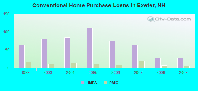
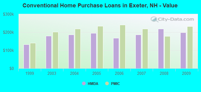
Detailed PMIC statistics for the following Tracts:0610.02
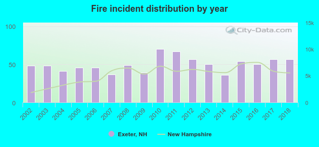
2002 - 2018 National Fire Incident Reporting System (NFIRS) incidents
According to the data from the years 2002 - 2018 the average number of fire incidents per year is 50. The highest number of reported fires - 70 took place in 2010, and the least - 36 in 2014. The data has a growing trend.
When looking into fire subcategories, the most reports belonged to: Structure Fires (52.7%), and Outside Fires (23.9%).
Fire incident types reported to NFIRS in Exeter, NH
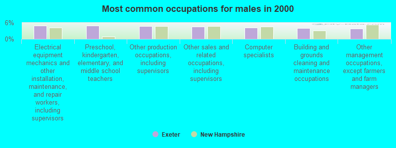
#20 on the list of "Top 101 cities with largest percentage of females in occupations: education, training, and library occupations (population 5,000+)"
#9 on the list of "Top 101 counties with the largest decrease in the number of births per 1000 residents 2000-2006 to 2007-2013 (pop 50,000+)"
#14 on the list of "Top 101 counties with the best general health status score of residents (1-5), 3 years of data"
#16 on the list of "Top 101 counties with the lowest number of births per 1000 residents 2007-2013"
#22 on the list of "Top 101 counties with the lowest Particulate Matter (PM10) Annual air pollution readings in 2012 (µg/m3)"
#36 on the list of "Top 101 counties with the highest percentage of residents that visited a dentist within the past year"


 Recent articles from our blog. Our writers, many of them Ph.D. graduates or candidates, create easy-to-read articles on a wide variety of topics.


 (15.3 miles


 According to the data from the years 2002 - 2018 the average number of fire incidents per year is 50. The highest number of reported fires - 70 took place in 2010, and the least - 36 in 2014. The data has a growing trend.
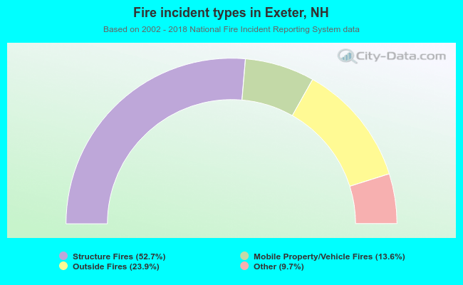 When looking into fire subcategories, the most reports belonged to: Structure Fires (52.7%), and Outside Fires (23.9%).