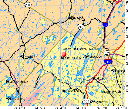
West Milford, New Jersey
Submit your own pictures of this place and show them to the world
- OSM Map
- General Map
- Google Map
- MSN Map
| Males: 13,122 | |
| Females: 13,086 |
| Median resident age: | 37.0 years |
| New Jersey median age: | 36.7 years |
Zip codes: 07480.
| West Milford: | $120,435 |
| NJ: | $96,346 |
Estimated per capita income in 2022: $50,230 (it was $28,612 in 2000)
West Milford CDP income, earnings, and wages data
Estimated median house or condo value in 2022: $401,765 (it was $171,300 in 2000)
| West Milford: | $401,765 |
| NJ: | $428,900 |
Mean prices in 2022: all housing units: $452,665; detached houses: $472,210; townhouses or other attached units: $393,680; in 2-unit structures: $480,413; in 3-to-4-unit structures: $364,785; in 5-or-more-unit structures: $297,736; mobile homes: $421,964
Detailed information about poverty and poor residents in West Milford, NJ


- 24,47492.7%White alone
- 8933.4%Hispanic
- 3141.2%Black alone
- 3171.2%Two or more races
- 2621.0%Asian alone
- 1230.5%American Indian alone
- 260.10%Other race alone
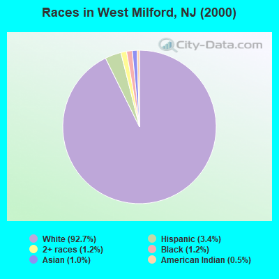
Races in West Milford detailed stats: ancestries, foreign born residents, place of birth
According to our research of New Jersey and other state lists, there were 6 registered sex offenders living in West Milford, New Jersey as of April 18, 2024.
The ratio of all residents to sex offenders in West Milford is 4,368 to 1.
The ratio of registered sex offenders to all residents in this city is much lower than the state average.
Type |
2009 |
2010 |
2011 |
2012 |
2013 |
2014 |
2015 |
2016 |
2017 |
2018 |
2019 |
2020 |
2021 |
2022 |
|---|---|---|---|---|---|---|---|---|---|---|---|---|---|---|
| Murders (per 100,000) | 1 (3.6) | 0 (0.0) | 0 (0.0) | 1 (3.8) | 0 (0.0) | 0 (0.0) | 0 (0.0) | 0 (0.0) | 0 (0.0) | 0 (0.0) | 0 (0.0) | 0 (0.0) | 0 (0.0) | 0 (0.0) |
| Rapes (per 100,000) | 1 (3.6) | 4 (15.5) | 1 (3.9) | 3 (11.5) | 4 (15.3) | 2 (7.5) | 4 (15.0) | 6 (22.4) | 4 (14.9) | 2 (7.5) | 2 (7.6) | 2 (7.6) | 1 (3.7) | 2 (8.2) |
| Robberies (per 100,000) | 4 (14.3) | 6 (23.2) | 1 (3.9) | 1 (3.8) | 3 (11.5) | 4 (15.0) | 1 (3.7) | 3 (11.2) | 0 (0.0) | 0 (0.0) | 1 (3.8) | 1 (3.8) | 1 (3.7) | 0 (0.0) |
| Assaults (per 100,000) | 20 (71.7) | 8 (30.9) | 17 (65.5) | 13 (50.0) | 17 (65.1) | 15 (56.3) | 14 (52.5) | 14 (52.4) | 21 (78.4) | 8 (30.1) | 10 (38.0) | 8 (30.4) | 6 (21.9) | 3 (12.3) |
| Burglaries (per 100,000) | 96 (344.3) | 103 (398.5) | 100 (385.6) | 78 (299.8) | 98 (375.6) | 87 (326.8) | 63 (236.1) | 72 (269.3) | 37 (138.2) | 23 (86.6) | 18 (68.5) | 7 (26.6) | 10 (36.6) | 6 (24.6) |
| Thefts (per 100,000) | 242 (868.0) | 185 (715.7) | 196 (755.7) | 216 (830.2) | 174 (666.8) | 156 (586.0) | 148 (554.8) | 138 (516.2) | 155 (579.0) | 127 (478.2) | 104 (395.6) | 83 (315.5) | 54 (197.4) | 58 (238.0) |
| Auto thefts (per 100,000) | 12 (43.0) | 8 (30.9) | 8 (30.8) | 11 (42.3) | 5 (19.2) | 14 (52.6) | 10 (37.5) | 6 (22.4) | 11 (41.1) | 8 (30.1) | 5 (19.0) | 3 (11.4) | 4 (14.6) | 6 (24.6) |
| Arson (per 100,000) | 2 (7.2) | 9 (34.8) | 2 (7.7) | 2 (7.7) | 1 (3.8) | 1 (3.8) | 0 (0.0) | 0 (0.0) | 1 (3.7) | 2 (7.5) | 1 (3.8) | 0 (0.0) | 0 (0.0) | 0 (0.0) |
| City-Data.com crime index | 91.0 | 84.5 | 77.0 | 85.6 | 83.2 | 72.3 | 65.3 | 73.1 | 63.8 | 39.6 | 37.0 | 28.7 | 20.0 | 22.2 |
The City-Data.com crime index weighs serious crimes and violent crimes more heavily. Higher means more crime, U.S. average is 246.1. It adjusts for the number of visitors and daily workers commuting into cities.
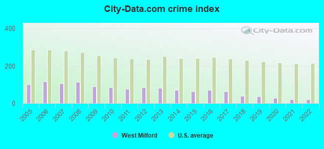
Crime rate in West Milford detailed stats: murders, rapes, robberies, assaults, burglaries, thefts, arson
Full-time law enforcement employees in 2021, including police officers: 51 (44 officers - 39 male; 5 female).
| Officers per 1,000 residents here: | 1.61 |
| New Jersey average: | 5.53 |
 Recent articles from our blog. Our writers, many of them Ph.D. graduates or candidates, create easy-to-read articles on a wide variety of topics.


 | Black family wanting to move to West Milford, NJ (43 replies) |
| Murphy to eliminate mask mandate in New Jersey schools beginning in March (173 replies) |
| Recommendations for towns to look into for moving to Jersey (30 replies) |
| NJ Cities/Large Suburbs, Ranked (56 replies) |
| Jersey's Burning (10 replies) |
| Scenic, small town recs - WFH - looking for a change (9 replies) |
Latest news from West Milford, NJ collected exclusively by city-data.com from local newspapers, TV, and radio stations
Ancestries: Italian (26.3%), Irish (25.4%), German (24.7%), English (10.5%), Polish (9.7%), Dutch (6.3%).
Current Local Time: EST time zone
Elevation: 710 feet
Land area: 75.4 square miles.
Population density: 347 people per square mile (very low).

1,528 residents are foreign born (3.7% Europe, 1.0% Latin America, 0.8% Asia).
| This place: | 5.8% |
| New Jersey: | 17.5% |
| West Milford CDP: | 2.8% ($4,787) |
| New Jersey: | 2.4% ($4,047) |
Nearest city with pop. 50,000+: Wayne, NJ  (14.0 miles , pop. 54,069).
Nearest city with pop. 200,000+: Newark, NJ (28.5 miles , pop. 273,546).
Nearest city with pop. 1,000,000+: Manhattan, NY (32.3 miles , pop. 1,537,195).
Nearest cities:
), ), ), Latitude: 41.12 N, Longitude: 74.38 W
Daytime population change due to commuting: -8,778 (-33.2%)
Workers who live and work in this place: 2,648 (19.0%)
Area code: 973
West Milford, New Jersey accommodation & food services, waste management - Economy and Business Data
| Here: | 5.7% |
| New Jersey: | 4.5% |

- Educational services (9.4%)
- Construction (9.2%)
- Professional, scientific, technical services (7.3%)
- Health care (6.9%)
- Finance & insurance (5.9%)
- Public administration (3.5%)
- Food & beverage stores (3.3%)
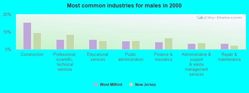
- Construction (15.4%)
- Professional, scientific, technical services (5.7%)
- Educational services (5.6%)
- Public administration (4.8%)
- Finance & insurance (4.3%)
- Administrative & support & waste management services (3.4%)
- Repair & maintenance (3.4%)
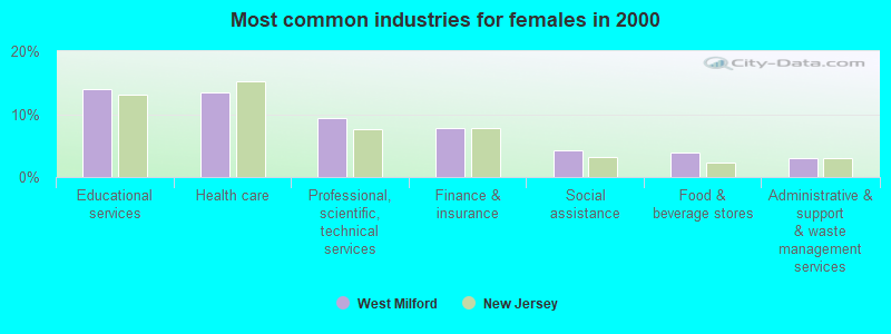
- Educational services (14.0%)
- Health care (13.5%)
- Professional, scientific, technical services (9.3%)
- Finance & insurance (7.9%)
- Social assistance (4.2%)
- Food & beverage stores (4.0%)
- Administrative & support & waste management services (3.0%)
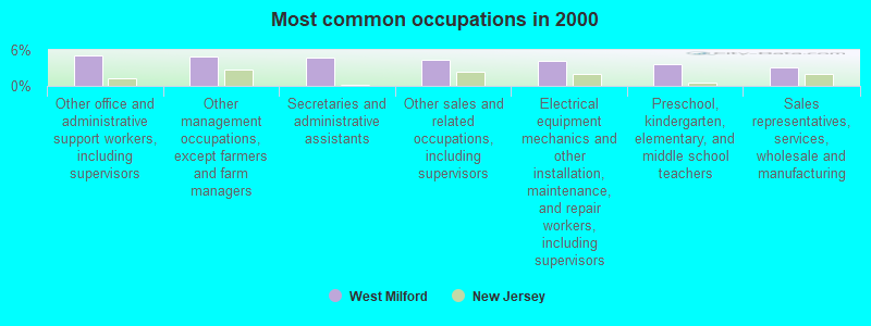
- Other office and administrative support workers, including supervisors (5.2%)
- Other management occupations, except farmers and farm managers (4.9%)
- Secretaries and administrative assistants (4.8%)
- Other sales and related occupations, including supervisors (4.4%)
- Electrical equipment mechanics and other installation, maintenance, and repair workers, including supervisors (4.1%)
- Preschool, kindergarten, elementary, and middle school teachers (3.7%)
- Sales representatives, services, wholesale and manufacturing (3.1%)
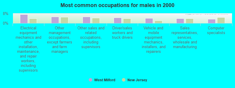
- Electrical equipment mechanics and other installation, maintenance, and repair workers, including supervisors (7.4%)
- Other management occupations, except farmers and farm managers (5.4%)
- Other sales and related occupations, including supervisors (5.2%)
- Driver/sales workers and truck drivers (4.7%)
- Vehicle and mobile equipment mechanics, installers, and repairers (4.2%)
- Sales representatives, services, wholesale and manufacturing (3.9%)
- Computer specialists (3.4%)
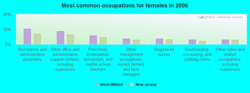
- Secretaries and administrative assistants (10.6%)
- Other office and administrative support workers, including supervisors (9.1%)
- Preschool, kindergarten, elementary, and middle school teachers (6.1%)
- Other management occupations, except farmers and farm managers (4.2%)
- Registered nurses (4.1%)
- Bookkeeping, accounting, and auditing clerks (3.6%)
- Other sales and related occupations, including supervisors (3.4%)
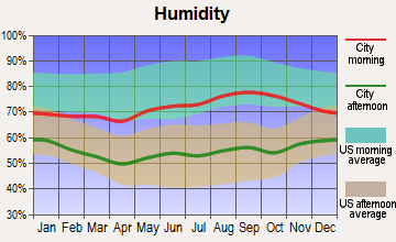
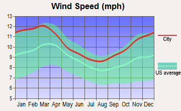
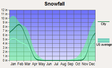
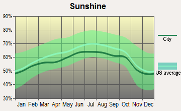
Average climate in West Milford, New Jersey
Based on data reported by over 4,000 weather stations
|
|

(lower is better)
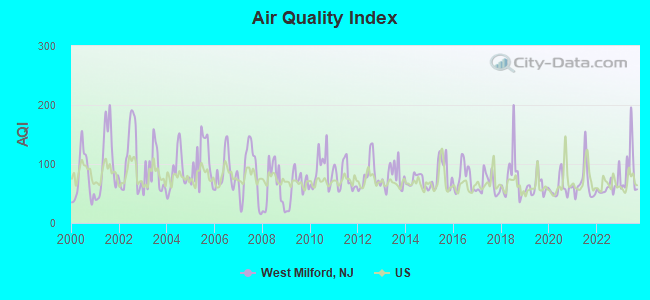
Air Quality Index (AQI) level in 2023 was 88.9. This is worse than average.
| City: | 88.9 |
| U.S.: | 72.6 |
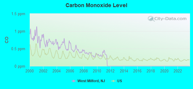
Carbon Monoxide (CO) [ppm] level in 2010 was 0.323. This is worse than average. Closest monitor was 17.7 miles away from the city center.
| City: | 0.323 |
| U.S.: | 0.251 |
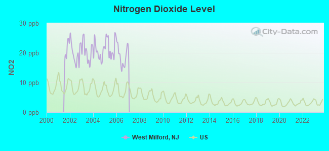
Nitrogen Dioxide (NO2) [ppb] level in 2006 was 18.8. This is significantly worse than average. Closest monitor was 18.1 miles away from the city center.
| City: | 18.8 |
| U.S.: | 5.1 |
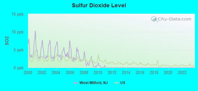
Sulfur Dioxide (SO2) [ppb] level in 2010 was 0.371. This is significantly better than average. Closest monitor was 17.0 miles away from the city center.
| City: | 0.371 |
| U.S.: | 1.515 |
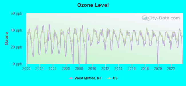
Ozone [ppb] level in 2023 was 32.4. This is about average. Closest monitor was 7.9 miles away from the city center.
| City: | 32.4 |
| U.S.: | 33.3 |
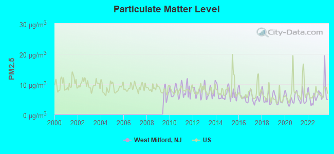
Particulate Matter (PM2.5) [µg/m3] level in 2023 was 7.80. This is about average. Closest monitor was 17.8 miles away from the city center.
| City: | 7.80 |
| U.S.: | 8.11 |
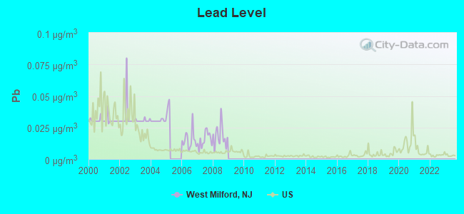
Lead (Pb) [µg/m3] level in 2008 was 0.0184. This is significantly worse than average. Closest monitor was 17.8 miles away from the city center.
| City: | 0.0184 |
| U.S.: | 0.0093 |
Tornado activity:
West Milford-area historical tornado activity is near New Jersey state average. It is 33% smaller than the overall U.S. average.
On 7/14/1988, a category F3 (max. wind speeds 158-206 mph) tornado 15.3 miles away from the West Milford place center injured one person and caused between $500,000 and $5,000,000 in damages.
On 5/28/1973, a category F3 tornado 22.9 miles away from the place center caused between $50,000 and $500,000 in damages.
Earthquake activity:
West Milford-area historical earthquake activity is significantly above New Jersey state average. It is 67% smaller than the overall U.S. average.On 8/23/2011 at 17:51:04, a magnitude 5.8 (5.8 MW, Depth: 3.7 mi, Class: Moderate, Intensity: VI - VII) earthquake occurred 291.8 miles away from West Milford center
On 10/7/1983 at 10:18:46, a magnitude 5.3 (5.1 MB, 5.3 LG, 5.1 ML) earthquake occurred 196.1 miles away from the city center
On 4/20/2002 at 10:50:47, a magnitude 5.3 (5.3 ML, Depth: 3.0 mi) earthquake occurred 237.3 miles away from the city center
On 1/16/1994 at 01:49:16, a magnitude 4.6 (4.6 MB, 4.6 LG, Depth: 3.1 mi, Class: Light, Intensity: IV - V) earthquake occurred 102.4 miles away from West Milford center
On 4/20/2002 at 10:50:47, a magnitude 5.2 (5.2 MB, 4.2 MS, 5.2 MW, 5.0 MW) earthquake occurred 235.4 miles away from the city center
On 1/16/1994 at 00:42:43, a magnitude 4.2 (4.2 MB, 4.0 LG, Depth: 3.1 mi) earthquake occurred 101.2 miles away from West Milford center
Magnitude types: regional Lg-wave magnitude (LG), body-wave magnitude (MB), local magnitude (ML), surface-wave magnitude (MS), moment magnitude (MW)
Natural disasters:
The number of natural disasters in Passaic County (27) is a lot greater than the US average (15).Major Disasters (Presidential) Declared: 16
Emergencies Declared: 10
Causes of natural disasters: Hurricanes: 7, Floods: 6, Storms: 5, Heavy Rains: 3, Snowstorms: 3, Blizzards: 2, Water Shortages: 2, Winter Storms: 2, Power Outage: 1, Tornado: 1, Tropical Storm: 1, Wind: 1, Other: 3 (Note: some incidents may be assigned to more than one category).

Hospitals and medical centers in West Milford:
Other hospitals and medical centers near West Milford:
- MILFORD MANOR (Nursing Home, about 4 miles away; WEST NEW MILFORD, NJ)
- HEALTH CENTER AT BLOOMINGDALE (Nursing Home, about 8 miles away; BLOOMINGDALE, NJ)
- WANAQUE CONVALESCENT CENTER (Nursing Home, about 9 miles away; HASKELL, NJ)
- SCHERVIER PAVILION (Nursing Home, about 11 miles away; WARWICK, NY)
- OAK RIDGE NURSIMG CENTER (Nursing Home, about 11 miles away; WAYNE, NJ)
- OAK RIDGE REHABILITATION AND NC (Nursing Home, about 11 miles away; WAYNE, NJ)
- ADVANCED CARE CENTER AT LAKEVIEW (Nursing Home, about 11 miles away; WAYNE, NJ)
Airports and other landing facilities located in West Milford:
- Greenwood Lake Airport (4N1) (Runways: 1, Itinerant Ops: 3,620, Local Ops: 14,479)
- Hill Top Airport (JY43) (Runways: 1)
- Greenwood Lake Seaplane Base (6NJ7)
Colleges/universities with over 2000 students nearest to West Milford:
- William Paterson University of New Jersey (about 16 miles; Wayne, NJ; Full-time enrollment: 10,198)
- Rockland Community College (about 16 miles; Suffern, NY; FT enrollment: 6,026)
- Ramapo College of New Jersey (about 16 miles; Mahwah, NJ; FT enrollment: 5,864)
- Passaic County Community College (about 18 miles; Paterson, NJ; FT enrollment: 6,351)
- Berkeley College-Woodland Park (about 19 miles; Woodland Park, NJ; FT enrollment: 2,938)
- Bergen Community College (about 19 miles; Paramus, NJ; FT enrollment: 11,826)
- Sussex County Community College (about 20 miles; Newton, NJ; FT enrollment: 2,402)
Public high school in West Milford:
- WEST DEPTFORD HIGH SCHOOL (Students: 1,420, Location: 1600 OLD CROWN POINT RD, Grades: 9-12)
Public elementary/middle schools in West Milford:
- WEST DEPTFORD MIDDLE SCHOOL (Students: 1,005, Location: 675 GROVE RD, Grades: 5-8)
- OAKVIEW ELEMENTARY SCHOOL (Students: 393, Location: 350 DUBOIS AVE, Grades: PK-1)
- RED BANK ELEMENTARY SCHOOL (Students: 280, Location: 192 PHILADELPHIA AVE, Grades: KG-2)
User-submitted facts and corrections:
- you are missing 2 of the elementary schools in West Milford. There is Upper Greenwood Lake grades K - 6 and Paradise Knoll also K - 6.
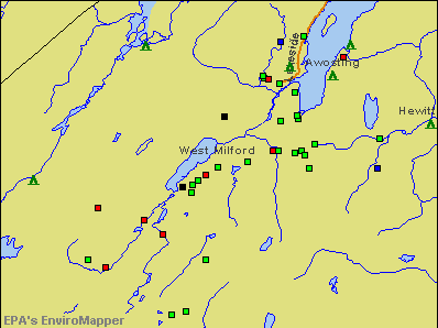
Points of interest:
Notable locations in West Milford: Camp Hope (A), West Milford Township First Aid Squad Newfoundland Substation (B), West Milford Township First Aid Squad Main Station (C), Township of West Milford Fire Department Upper Greenwood Lake Company 5 (D), Township of West Milford Fire Department Community Volunteer Fire Company 2 (E), Township of West Milford Fire Department Macopin Volunteer Fire Company 4 (F), Township of West Milford Fire Department Apshawa Volunteer Fire Company 1 (G), Township of West Milford Fire Department West Milford Volunteer Fire Company 6 (H), Township of West Milford Fire Department Greenwood Forest Volunteer Fire Company 3 (I). Display/hide their locations on the map
Churches in West Milford include: Greenwood Church (A), Holy Faith Lutheran Church (B), Philadelphia Church (C), Saint Joseph Church (D), Oak Ridge Presbyterian Church (E), Church of the Incarnation (F), Our Lady Queen of Peace Church (G), West Milford Presbyterian Church (H), Echo Lake Baptist Church (I). Display/hide their locations on the map
Cemeteries: Cedar Heights Cemetery (1), Vreeland Cemetery (2), Saint Joseph's Roman Catholic Cemetery (3), Oak Ridge Presbyterian Church Cemetery (4), Turner Cemetery (5). Display/hide their locations on the map
Lakes and reservoirs: Green Valley Lake (A), Leeper Pond (B), Bubbling Spring Lake (C), Johns Lake (D), Greenwood Pond (E), West Pond (F), Genaders Pond (G), Wallace Pond (H). Display/hide their locations on the map
Streams, rivers, and creeks: Kanouse Brook (A), Hewitt Brook (B), Green Brook (C), Macopin River (D), Cooley Brook (E), Clinton Brook (F), Belcher Creek (G), Apshawa Brook (H), Matthews Brook (I). Display/hide their locations on the map
Parks in West Milford include: Browns Point (1), Longpond Ironworks State Park (2), San Cap County Park (3), Wanaque Wildlife Management Area (4). Display/hide their locations on the map
Birthplace of: Diana Falzone - Television personality.
Drinking water stations with addresses in West Milford and their reported violations in the past:
VALLEY VIEW PUB (Population served: 310, Groundwater):Past monitoring violations:WEST MILFORD ELKS LODGE (Population served: 202, Groundwater):
- 3 routine major monitoring violations
- One regular monitoring violation
Past monitoring violations:TOWN TAVERN COUNTRY INN/WELL1 (Population served: 163, Groundwater):
- Monitoring, Source Water (GWR) - Between FEB-07-2013 and FEB-28-2013, Contaminant: E. COLI. Follow-up actions: St Compliance achieved (FEB-01-2013), St Public Notif requested (FEB-13-2013), St Formal NOV issued (FEB-13-2013)
- One regular monitoring violation
Past health violations:WEST MILFORD BAR & LIQUOR (Address: 717 OTTERHOLE RD , Population served: 156, Groundwater):Past monitoring violations:
- MCL, Monthly (TCR) - In AUG-2010, Contaminant: Coliform. Follow-up actions: St Public Notif received (AUG-24-2010), St Public Notif requested (AUG-26-2010), St Formal NOV issued (AUG-26-2010), St Compliance achieved (SEP-29-2010)
- Monitoring, Repeat Major (TCR) - Between OCT-2010 and DEC-2010, Contaminant: Coliform (TCR)
Past health violations:MILFORD MANOR (Population served: 115, Groundwater):Past monitoring violations:
- MCL, Monthly (TCR) - Between OCT-2005 and DEC-2005, Contaminant: Coliform. Follow-up actions: St Public Notif requested (DEC-13-2005), St Formal NOV issued (DEC-13-2005), St Compliance achieved (MAR-31-2006)
- 2 routine major monitoring violations
Past health violations:TEEN COFFEE HOUSE (Population served: 52, Groundwater):Past monitoring violations:
- MCL, Monthly (TCR) - In JUL-2012, Contaminant: Coliform. Follow-up actions: St Public Notif requested (JUL-19-2012), St Formal NOV issued (JUL-19-2012), St Public Notif received (AUG-06-2012), St Compliance achieved (AUG-15-2012)
- Monitoring, Source Water (GWR) - In JAN-2010, Contaminant: E. COLI. Follow-up actions: St Compliance achieved (JAN-25-2010), St Public Notif requested (DEC-13-2010), St Formal NOV issued (DEC-13-2010)
- One routine major monitoring violation
- One regular monitoring violation
Past monitoring violations:
- 2 routine major monitoring violations
- One regular monitoring violation
Drinking water stations with addresses in West Milford that have no violations reported:
- WEST MILFORD LIBRARY (Population served: 210, Primary Water Source Type: Groundwater)
- THE VREELAND STORE (Population served: 154, Primary Water Source Type: Groundwater)
- WEST MILFORD MUA GREENWOOD LAKE BEACH (Address: SUITE 221 , Population served: 52, Primary Water Source Type: Groundwater)
- WEST MILFORD ROAD DEPART (Population served: 43, Primary Water Source Type: Groundwater)
| This place: | 2.8 people |
| New Jersey: | 2.7 people |
| This place: | 78.2% |
| Whole state: | 70.7% |
| This place: | 5.2% |
| Whole state: | 4.9% |
Likely homosexual households (counted as self-reported same-sex unmarried-partner households)
- Lesbian couples: 0.4% of all households
- Gay men: 0.3% of all households
| This place: | 4.1% |
| Whole state: | 8.5% |
| This place: | 1.7% |
| Whole state: | 4.2% |
People in group quarters in West Milford in 2000:
- 120 people in other noninstitutional group quarters
- 109 people in nursing homes
- 33 people in other group homes
- 26 people in other workers' dormitories
- 12 people in homes for the mentally retarded
Banks with branches in West Milford (2011 data):
- Bank of America, National Association: West Milford Branch at 1618 Union Valley Road, branch established on 1989/12/28. Info updated 2009/11/18: Bank assets: $1,451,969.3 mil, Deposits: $1,077,176.8 mil, headquarters in Charlotte, NC, positive income, 5782 total offices, Holding Company: Bank Of America Corporation
- Lakeland Bank: West Milford Branch at 1527 Union Valley Road, branch established on 1992/10/06. Info updated 2009/08/05: Bank assets: $2,820.0 mil, Deposits: $2,260.3 mil, headquarters in Newfoundland, NJ, positive income, Commercial Lending Specialization, 48 total offices, Holding Company: Lakeland Bancorp, Inc.
- Columbia Bank: West Milford Branch at 1501 Union Valley Road, branch established on 1996/12/07. Info updated 2011/07/21: Bank assets: $4,478.2 mil, Deposits: $2,795.4 mil, headquarters in Fair Lawn, NJ, positive income, Commercial Lending Specialization, 44 total offices
- Wells Fargo Bank, National Association: West Milford at 1 Marshall Hill Rd, branch established on 1940/01/01. Info updated 2011/04/05: Bank assets: $1,161,490.0 mil, Deposits: $905,653.0 mil, headquarters in Sioux Falls, SD, positive income, 6395 total offices, Holding Company: Wells Fargo & Company
- Hudson City Savings Bank: West Milford Branch at 35a Marshall Hill Road, branch established on 1981/12/21. Info updated 2012/01/09: Bank assets: $45,373.6 mil, Deposits: $25,645.6 mil, headquarters in Paramus, NJ, negative income in the last year, Mortgage Lending Specialization, 135 total offices
For population 15 years and over in West Milford:
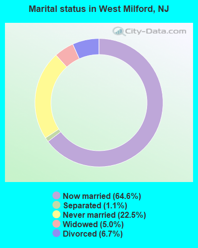
- Never married: 22.5%
- Now married: 64.6%
- Separated: 1.1%
- Widowed: 5.0%
- Divorced: 6.7%
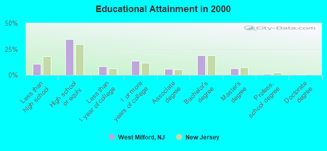
For population 25 years and over in West Milford:
- High school or higher: 89.3%
- Bachelor's degree or higher: 27.2%
- Graduate or professional degree: 8.0%
- Unemployed: 4.3%
- Mean travel time to work (commute): 38.3 minutes
| Here: | 9.8 |
| New Jersey average: | 13.1 |
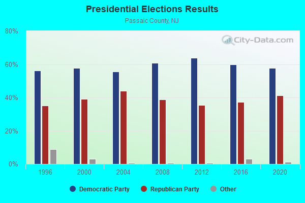
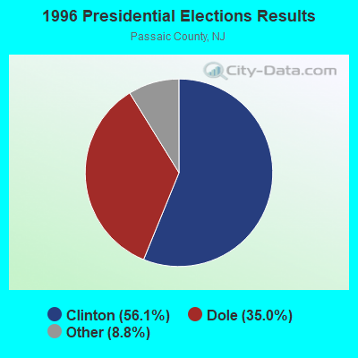
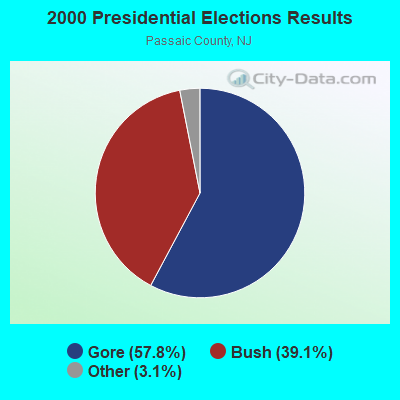
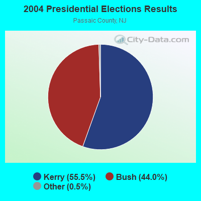
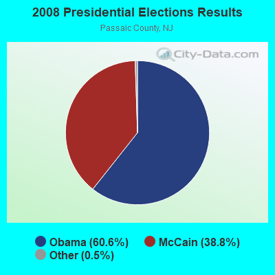
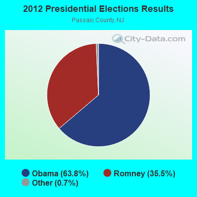


Graphs represent county-level data. Detailed 2008 Election Results
Neighborhoods in West Milford:
(West Milford, New Jersey Neighborhood Map)Religion statistics for West Milford, NJ (based on Passaic County data)
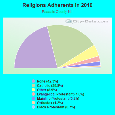
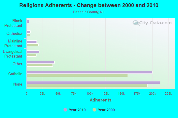
| Religion | Adherents | Congregations |
|---|---|---|
| Catholic | 199,315 | 56 |
| Other | 44,397 | 51 |
| Evangelical Protestant | 20,164 | 110 |
| Mainline Protestant | 15,796 | 83 |
| Orthodox | 5,990 | 14 |
| Black Protestant | 3,610 | 16 |
| None | 211,954 | - |
Food Environment Statistics:
| Passaic County: | 4.33 / 10,000 pop. |
| New Jersey: | 2.90 / 10,000 pop. |
| This county: | 0.04 / 10,000 pop. |
| New Jersey: | 0.06 / 10,000 pop. |
| Passaic County: | 1.31 / 10,000 pop. |
| New Jersey: | 1.76 / 10,000 pop. |
| Here: | 0.65 / 10,000 pop. |
| New Jersey: | 0.81 / 10,000 pop. |
| Passaic County: | 5.72 / 10,000 pop. |
| New Jersey: | 7.15 / 10,000 pop. |
| Here: | 8.1% |
| State: | 8.3% |
| Passaic County: | 24.7% |
| State: | 23.3% |
| Here: | 18.3% |
| New Jersey: | 18.0% |
5.27% of this county's 2021 resident taxpayers lived in other counties in 2020 ($68,330 average adjusted gross income)
| Here: | 5.27% |
| New Jersey average: | 6.70% |
0.02% of residents moved from foreign countries ($18 average AGI)
Passaic County: 0.02% New Jersey average: 0.01%
Top counties from which taxpayers relocated into this county between 2020 and 2021:
| from Bergen County, NJ | |
| from Essex County, NJ | |
| from Hudson County, NJ |
6.56% of this county's 2020 resident taxpayers moved to other counties in 2021 ($73,505 average adjusted gross income)
| Here: | 6.56% |
| New Jersey average: | 7.02% |
0.01% of residents moved to foreign countries ($57 average AGI)
Passaic County: 0.01% New Jersey average: 0.02%
Top counties to which taxpayers relocated from this county between 2020 and 2021:
| to Bergen County, NJ | |
| to Morris County, NJ | |
| to Essex County, NJ |
| Businesses in West Milford, NJ | ||||
| Name | Count | Name | Count | |
|---|---|---|---|---|
| Dairy Queen | 1 | McDonald's | 1 | |
| Dunkin Donuts | 1 | RadioShack | 1 | |
| Goodwill | 1 | Rite Aid | 1 | |
| H&R Block | 1 | UPS | 1 | |
| MasterBrand Cabinets | 1 | Walgreens | 1 | |
Strongest AM radio stations in West Milford:
- WVNJ (1160 AM; 20 kW; OAKLAND, NJ; Owner: UNIVERSAL B/CASTING OF NEW YORK,INC.)
- WSNR (620 AM; 20 kW; JERSEY CITY, NJ)
- WABC (770 AM; 50 kW; NEW YORK, NY; Owner: WABC-AM RADIO, INC.)
- WMCA (570 AM; 50 kW; NEW YORK, NY; Owner: SALEM MEDIA OF NEW YORK, LLC)
- WOR (710 AM; 50 kW; NEW YORK, NY; Owner: BUCKLEY BROADCASTING CORPORATION)
- WINS (1010 AM; 50 kW; NEW YORK, NY; Owner: INFINITY BROADCASTING OPERATIONS, INC.)
- WEPN (1050 AM; 50 kW; NEW YORK, NY; Owner: NEW YORK AM RADIO, LLC)
- WADO (1280 AM; 50 kW; NEW YORK, NY; Owner: WADO-AM LICENSE CORP.)
- WBBR (1130 AM; 50 kW; NEW YORK, NY; Owner: BLOOMBERG COMMUNICATIONS INC.)
- WFAN (660 AM; 50 kW; NEW YORK, NY; Owner: INFINITY BROADCASTING OPERATIONS, INC.)
- WCBS (880 AM; 50 kW; NEW YORK, NY; Owner: INFINITY BROADCASTING OPERATIONS, INC.)
- WLIB (1190 AM; 30 kW; NEW YORK, NY; Owner: ICBC BROADCAST HOLDINGS-NY, INC.)
- WQEW (1560 AM; 50 kW; NEW YORK, NY; Owner: THE NEW YORK TIMES ELECTRONIC MEDIA COMPANY)
Strongest FM radio stations in West Milford:
- WSUS (102.3 FM; FRANKLIN, NJ; Owner: CLEAR CHANNEL BROADCASTING LICENSES, INC.)
- WNJP (88.5 FM; SUSSEX, NJ; Owner: NEW JERSEY PUBLIC BROADCASTING AUTH.)
- WRKS (98.7 FM; NEW YORK, NY; Owner: EMMIS RADIO LICENSE CORP OF NEW YORK)
- WNEW (102.7 FM; NEW YORK, NY; Owner: INFINITY BROADCASTING OPERATIONS, INC.)
- WPLJ (95.5 FM; NEW YORK, NY; Owner: WPLJ-FM RADIO, INC.)
- WLJP (89.3 FM; MONROE, NY; Owner: SOUND OF LIFE, INC.)
- WKCR-FM (89.9 FM; NEW YORK, NY; Owner: TRUSTEES OF COLUMBIA UNIVERSITY IN NEW YORK)
- WKTU (103.5 FM; LAKE SUCCESS, NY; Owner: AMFM RADIO LICENSES, LLC)
- WQCD (101.9 FM; NEW YORK, NY; Owner: EMMIS RADIO LICENSE CORPORATION)
- WAXQ (104.3 FM; NEW YORK, NY; Owner: AMFM NEW YORK LICENSES, LLC)
- WHTZ (100.3 FM; NEWARK, NJ; Owner: AMFM RADIO LICENSES, L.L.C.)
- WWPR-FM (105.1 FM; NEW YORK, NY; Owner: AMFM RADIO LICENSES, L.L.C.)
- WNYC-FM (93.9 FM; NEW YORK, NY; Owner: WNYC RADIO)
- WCAA (105.9 FM; NEWARK, NJ; Owner: WADO-AM LICENSE CORP. ("WADO"))
- WBAI (99.5 FM; NEW YORK, NY; Owner: PACIFICA FOUNDATION, INC.)
- WBLS (107.5 FM; NEW YORK, NY; Owner: ICBC BROADCAST HOLDINGS-NY, INC.)
- WLTW (106.7 FM; NEW YORK, NY; Owner: AMFM NEW YORK LICENSES, LLC)
- WQXR-FM (96.3 FM; NEW YORK, NY; Owner: THE NEW YORK TIMES ELECTRONIC MEDIA COMPANY)
- WSKQ-FM (97.9 FM; NEW YORK, NY; Owner: WSKQ LICENSING, INC.)
- WXRK (92.3 FM; NEW YORK, NY; Owner: INFINITY BROADCASTING OPERATIONS, INC.)
TV broadcast stations around West Milford:
- WFME-TV (Channel 66; WEST MILFORD, NJ; Owner: FAMILY STATIONS, INC.)
- WMBC-TV (Channel 63; NEWTON, NJ; Owner: MOUNTAIN BROADCASTING CORPORATION)
- WNYW (Channel 5; NEW YORK, NY; Owner: FOX TELEVISION STATIONS, INC.)
- WCBS-TV (Channel 2; NEW YORK, NY; Owner: CBS BROADCASTING INC.)
- WPXO-LP (Channel 34; EAST ORANGE, NJ; Owner: PAXSON COMMUNICATIONS LPTV, INC.)
- WABC-TV (Channel 7; NEW YORK, NY; Owner: AMERICAN BROADCASTING COMPANIES, INC)
- WPIX (Channel 11; NEW YORK, NY; Owner: WPIX, INC.)
- WWOR-TV (Channel 9; SECAUCUS, NJ; Owner: FOX TELEVISION STATIONS, INC.)
- WNJU (Channel 47; LINDEN, NJ; Owner: WNJU LICENSE CORPORATION)
- WPXN-TV (Channel 31; NEW YORK, NY; Owner: PAXSON COMMUNICATIONS LICENSE COMPANY, LLC)
- WFUT (Channel 68; NEWARK, NJ; Owner: UNIVISION NEW YORK LLC)
- WNBC (Channel 4; NEW YORK, NY; Owner: NATIONAL BROADCASTING COMPANY, INC.)
- WNET (Channel 13; NEWARK, NJ; Owner: EDUCATIONAL BROADCASTING CORPORATION)
- WXTV (Channel 41; PATERSON, NJ; Owner: WXTV LICENSE PARTNERSHIP, G.P.)
- WNYE-TV (Channel 25; NEW YORK, NY; Owner: NEW YORK CITY BOARD OF EDUCATION)
- WXNY-LP (Channel 32; NEW YORK, NY; Owner: ISLAND BROADCASTING COMPANY)
- W36AZ (Channel 36; SUSSEX, NJ; Owner: NEW JERSEY PUBLIC B/CING. AUTHORITY)
- WKOB-LP (Channel 53; NEW YORK, NY; Owner: WKOB COMMUNICATIONS, INC.)
- WEBR-CA (Channel 17; MANHATTAN, NY; Owner: K LICENSEE INC.)
- WRNN-LP (Channel 57; NYACK, NY; Owner: LP NYACK LIMITED PARTNERSHIP)
- W68DN (Channel 68; CHERRY HILL, ETC., NJ; Owner: MARCIA COHEN)
- W60AI (Channel 60; NEW YORK, NY; Owner: VENTANA TELEVISION, INC.)
- WTBY (Channel 54; POUGHKEEPSIE, NY; Owner: TRINITY BROADCASTING OF NEW YORK, INC.)
- WNXY-LP (Channel 26; NEW YORK, NY; Owner: ISLAND BROADCASTING COMPANY)
- W33BS (Channel 33; DARIEN, CT; Owner: CT&T BROADCASTING, INC.)
- National Bridge Inventory (NBI) Statistics
- 20Number of bridges
- 121ft / 37.2mTotal length
- $10,586,000Total costs
- 217,333Total average daily traffic
- 8,453Total average daily truck traffic
- 263,605Total future (year 2040) average daily traffic
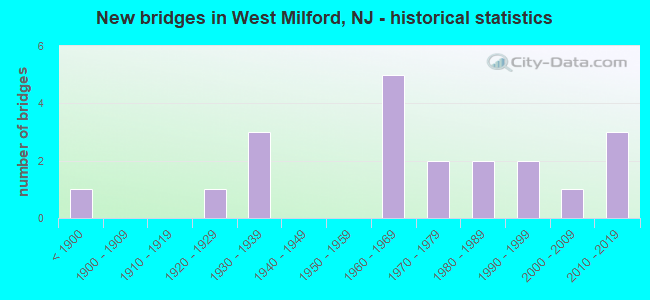
- New bridges - historical statistics
- 1Before 1900
- 11920-1929
- 31930-1939
- 51960-1969
- 21970-1979
- 21980-1989
- 21990-1999
- 12000-2009
- 32010-2019
FCC Registered Cell Phone Towers:
1 (See the full list of FCC Registered Cell Phone Towers in West Milford)FCC Registered Antenna Towers:
87 (See the full list of FCC Registered Antenna Towers)FCC Registered Broadcast Land Mobile Towers:
6- Community Fire Co Rt 23 Oakridge (Lat: 41.054806 Lon: -74.456556), Structure height: 6 m, Call Sign: WPCQ550,
Assigned Frequencies: 46.3800 MHz, Grant Date: 07/20/2023, Expiration Date: 07/12/2033, Registrant: 1480 Union Valley Road, West Milford, NJ 07480, Phone: (973) 728-2827, Email:
- Bearfort Fire Tower Fire Tower Rd (Lat: 41.103417 Lon: -74.419889), Call Sign: KYK307,
Assigned Frequencies: 45.0000 MHz, 151.475 MHz, 159.240 MHz, 159.270 MHz, 159.285 MHz, 159.300 MHz, 159.345 MHz, 159.375 MHz, 159.405 MHz, 159.465 MHz, Grant Date: 12/16/2014, Expiration Date: 03/05/2025, Registrant: Nj Forest Fire Service, 501 E. State St., Mc 501-4, 4th Floor, Trenton, NJ 08625-0420, Phone: (609) 292-2977, Fax: (609) 984-0378, Email:
- 1 Mi Ne (Lat: 41.136472 Lon: -74.366806), Structure height: 18 m, Call Sign: WNUH987,
Assigned Frequencies: 173.396 MHz, Grant Date: 07/26/2005, Expiration Date: 09/20/2015, Cancellation Date: 02/26/2007, Registrant: Tennessee Gas Pipeline Company, 27725 Stansbury Blvd., Suite #200, Farmington Hills, MI 48334, Phone: (248) 994-4020, Fax: (248) 994-4120, Email:
- 43a Marshall Hill Road (Lat: 41.131667 Lon: -74.364722), Call Sign: WQBP666,
Assigned Frequencies: 30.8400 MHz, 154.540 MHz, 33.4000 MHz, 33.1600 MHz, 31.2400 MHz, 468.487 MHz, 468.762 MHz, 468.837 MHz, 469.462 MHz, 469.637 MHz... (+22 more), Grant Date: 11/18/2004, Expiration Date: 11/18/2014, Cancellation Date: 01/24/2015, Certifier: Beth Cotner, Registrant: Dolfen Consulting Group, 95 Willow Lane, Bristol, IL 60512-9711, Phone: (630) 553-5886, Fax: (630) 566-1755, Email:
- Lat: 41.022389 Lon: -74.391917, Call Sign: WQSS505,
Assigned Frequencies: 452.087 MHz, 452.512 MHz, 456.487 MHz, Grant Date: 11/07/2013, Expiration Date: 11/07/2023, Cancellation Date: 01/13/2024, Certifier: James Goodger, Registrant: Electronic Service Solutions, Inc., 141 River Road # 6, Nutley, NJ 07110, Phone: (201) 488-2292, Fax: (201) 488-1690, Email:
- WEST MILFORD, NJ, 99 Marshall Hill Road (Lat: 41.132889 Lon: -74.359250), Call Sign: WRBX786,
Assigned Frequencies: 462.237 MHz, Grant Date: 07/19/2018, Expiration Date: 07/19/2028, Certifier: Glenn Kramer, Registrant: Buytwowayradios.Com, 528 S. Cherry Rd., Rock Hill, SC 29732, Phone: (803) 818-2228, Fax: (803) 985-8775, Email:
FCC Registered Microwave Towers:
1- NY33XC146, 1894 Route 23 N (Lat: 41.014694 Lon: -74.386944), Type: Mtower, Structure height: 36.6 m, Overall height: 37.5 m, Call Sign: WQVL891,
Assigned Frequencies: 11265.0 MHz, 11265.0 MHz, 11265.0 MHz, 11265.0 MHz, 11265.0 MHz, 11265.0 MHz, 11265.0 MHz, Grant Date: 03/24/2015, Expiration Date: 03/24/2025, Cancellation Date: 04/06/2022, Certifier: David Werblow, Registrant: Dla Piper LLP, 500 8th Street, Nw, Washington, DC 20004, Phone: (202) 799-4216, Fax: (202) 799-5616, Email:
FCC Registered Maritime Coast & Aviation Ground Towers:
2- Greenwood Lake Airport (Lat: 41.129444 Lon: -74.343056), Type: Mast, Structure height: 250 m, Overall height: 253 m, Call Sign: WQBV389,
Assigned Frequencies: 121.725 MHz, Grant Date: 10/31/2014, Expiration Date: 12/21/2024, Certifier: Ronald D Harbist, Registrant: Njdot Division Of Aeronautics, 1035 Parkway Ave., Trenton, NJ 08625-0600, Phone: (609) 530-2908, Fax: (609) 530-5270, Email:
- 126 Airport Road (Lat: 41.128611 Lon: -74.347222), Type: Pole, Structure height: 3 m, Call Sign: WRTE445,
Assigned Frequencies: 125.225 MHz, 124.150 MHz, Grant Date: 06/07/2022, Expiration Date: 06/12/2022, Cancellation Date: 08/13/2022, Certifier: Tim Wagner, Registrant: Greenwood Airport, 7601 N 181st Ave, Waddell, AZ 85355, Phone: (229) 834-2599, Email:
FCC Registered Amateur Radio Licenses:
73 (See the full list of FCC Registered Amateur Radio Licenses in West Milford)FAA Registered Aircraft Manufacturers and Dealers:
2 (See the full list of FAA Registered Manufacturers and Dealers in West Milford)FAA Registered Aircraft:
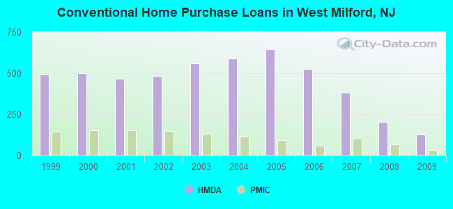
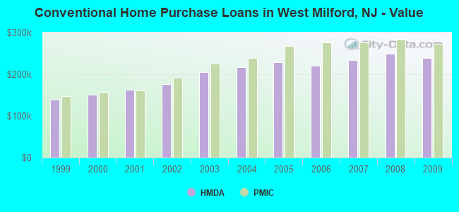
17 (See the full list of FAA Registered Aircraft)| Home Mortgage Disclosure Act Aggregated Statistics For Year 2009 (Based on 5 full tracts) | ||||||||||||
| A) FHA, FSA/RHS & VA Home Purchase Loans | B) Conventional Home Purchase Loans | C) Refinancings | D) Home Improvement Loans | E) Loans on Dwellings For 5+ Families | F) Non-occupant Loans on < 5 Family Dwellings (A B C & D) | |||||||
|---|---|---|---|---|---|---|---|---|---|---|---|---|
| Number | Average Value | Number | Average Value | Number | Average Value | Number | Average Value | Number | Average Value | Number | Average Value | |
| LOANS ORIGINATED | 83 | $249,831 | 129 | $238,930 | 770 | $230,942 | 63 | $109,190 | 1 | $350,000 | 26 | $249,308 |
| APPLICATIONS APPROVED, NOT ACCEPTED | 13 | $244,077 | 19 | $287,421 | 68 | $213,471 | 6 | $49,833 | 0 | $0 | 0 | $0 |
| APPLICATIONS DENIED | 14 | $258,214 | 14 | $206,786 | 355 | $253,090 | 33 | $91,606 | 0 | $0 | 15 | $251,267 |
| APPLICATIONS WITHDRAWN | 18 | $223,778 | 12 | $215,167 | 176 | $253,608 | 14 | $143,714 | 0 | $0 | 4 | $157,000 |
| FILES CLOSED FOR INCOMPLETENESS | 5 | $283,600 | 2 | $340,000 | 58 | $287,776 | 2 | $85,000 | 0 | $0 | 1 | $340,000 |
Detailed HMDA statistics for the following Tracts: 2568.01 , 2568.02, 2568.03, 2568.04, 2568.05
| Private Mortgage Insurance Companies Aggregated Statistics For Year 2009 (Based on 5 full tracts) | ||||
| A) Conventional Home Purchase Loans | B) Refinancings | |||
|---|---|---|---|---|
| Number | Average Value | Number | Average Value | |
| LOANS ORIGINATED | 28 | $272,714 | 16 | $300,438 |
| APPLICATIONS APPROVED, NOT ACCEPTED | 7 | $214,571 | 13 | $304,231 |
| APPLICATIONS DENIED | 8 | $273,500 | 5 | $268,600 |
| APPLICATIONS WITHDRAWN | 5 | $332,200 | 1 | $268,000 |
| FILES CLOSED FOR INCOMPLETENESS | 1 | $275,000 | 0 | $0 |
Detailed PMIC statistics for the following Tracts: 2568.01 , 2568.02, 2568.03, 2568.04, 2568.05
2004 - 2018 National Fire Incident Reporting System (NFIRS) incidents
- Fire incident types reported to NFIRS in West Milford, NJ
- 87758.3%Structure Fires
- 38425.5%Outside Fires
- 16511.0%Mobile Property/Vehicle Fires
- 785.2%Other
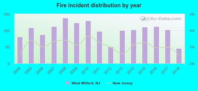 According to the data from the years 2004 - 2018 the average number of fire incidents per year is 100. The highest number of fire incidents - 138 took place in 2008, and the least - 46 in 2018. The data has a decreasing trend.
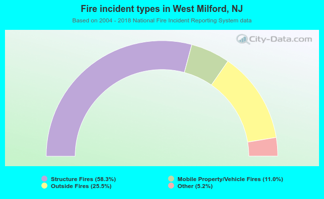 When looking into fire subcategories, the most incidents belonged to: Structure Fires (58.3%), and Outside Fires (25.5%).
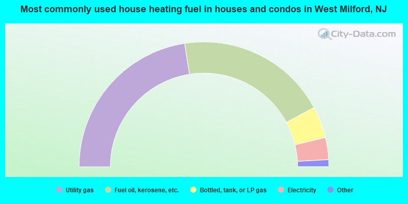
- 45.0%Utility gas
- 39.2%Fuel oil, kerosene, etc.
- 8.2%Bottled, tank, or LP gas
- 5.7%Electricity
- 1.5%Wood
- 0.2%Other fuel
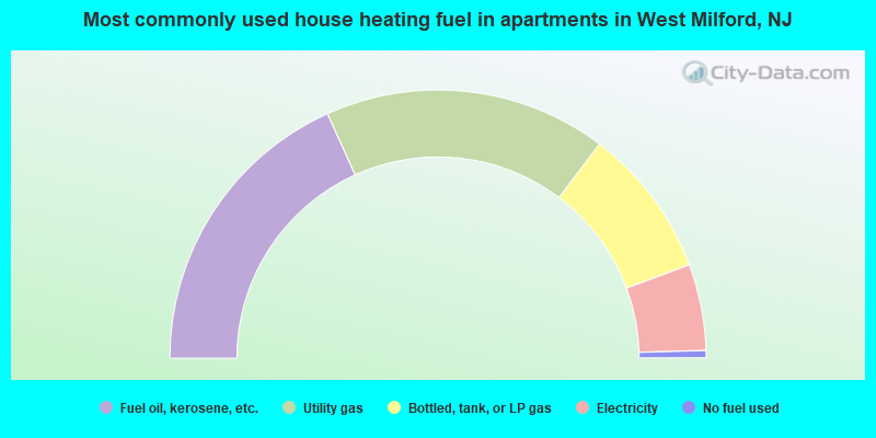
- 36.5%Fuel oil, kerosene, etc.
- 34.1%Utility gas
- 18.1%Bottled, tank, or LP gas
- 10.4%Electricity
- 0.9%No fuel used
West Milford compared to New Jersey state average:
- Unemployed percentage significantly below state average.
- Black race population percentage significantly below state average.
- Hispanic race population percentage significantly below state average.
- Median age below state average.
- Foreign-born population percentage significantly below state average.
- Renting percentage significantly below state average.
- Length of stay since moving in significantly above state average.
- Number of rooms per house significantly below state average.
- House age significantly below state average.
- Institutionalized population percentage significantly above state average.
West Milford on our top lists:
- #23 on the list of "Top 101 cities with largest percentage of females in industries: electrical and electronic goods merchant wholesalers (population 5,000+)"
- #36 on the list of "Top 101 cities with largest percentage of females in occupations: secretaries and administrative assistants (population 5,000+)"
- #39 on the list of "Top 101 cities with largest percentage of males in occupations: art and design workers (population 5,000+)"
- #39 on the list of "Top 101 cities with largest percentage of females in industries: apparel, fabrics, and notions merchant wholesalers (population 5,000+)"
- #42 on the list of "Top 101 cities with largest percentage of males in industries: motor vehicles, parts and supplies merchant wholesalers (population 5,000+)"
- #49 on the list of "Top 101 cities with largest percentage of females in industries: farm product raw materials merchant wholesalers (population 5,000+)"
- #52 on the list of "Top 101 cities with largest percentage of females in industries: chemicals (population 5,000+)"
- #52 on the list of "Top 101 cities with largest percentage of males in industries: drugs, sundries, and chemical and allied products merchant wholesalers (population 5,000+)"
- #55 on the list of "Top 101 cities with largest percentage of females in industries: drugs, sundries, and chemical and allied products merchant wholesalers (population 5,000+)"
- #58 on the list of "Top 101 cities with largest percentage of females in industries: publishing, and motion picture and sound recording industries (population 5,000+)"
- #80 on the list of "Top 101 cities with largest percentage of males in industries: sewing, needlework, and piece goods stores (population 5,000+)"
- #87 on the list of "Top 101 cities with largest percentage of females in occupations: other office and administrative support workers including supervisors (population 5,000+)"
- #88 on the list of "Top 101 cities with largest percentage of females in industries: farm supplies merchant wholesalers (population 5,000+)"
- #93 on the list of "Top 101 cities with largest percentage of males in occupations: other healthcare support occupations (population 5,000+)"
- #19 on the list of "Top 101 counties with the lowest percentage of residents that exercised in the past month"
- #22 on the list of "Top 101 counties with the largest number of people moving out compared to moving in (pop. 50,000+)"
- #23 on the list of "Top 101 counties with the largest decrease in the number of infant deaths per 1000 residents 2000-2006 to 2007-2013 (pop. 50,000+)"
- #24 on the list of "Top 101 counties with the highest surface withdrawal of fresh water for public supply (pop. 50,000+)"
- #25 on the list of "Top 101 counties with the lowest percentage of residents that keep firearms around their homes"

|
|
Total of 150 patent applications in 2008-2024.