Commack, New York Neighborhood Map - Income, House Prices, Occupations, Boundaries
Settings
X

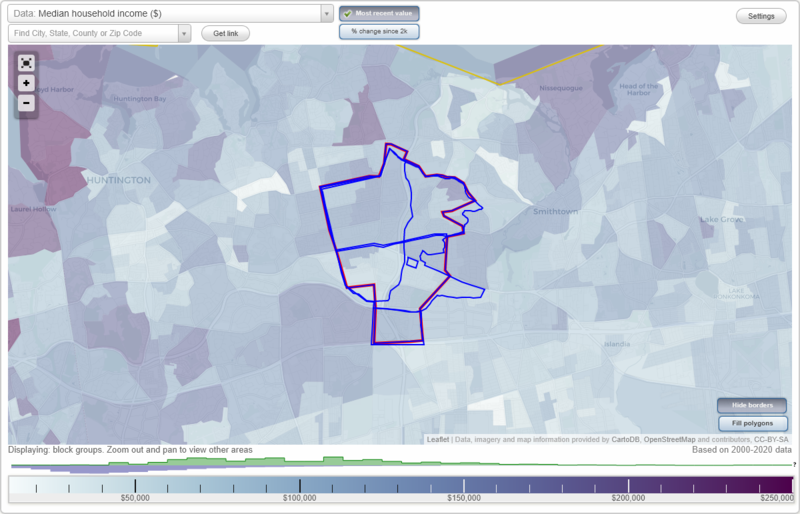
- City boundary
- Neighborhood boundaries
Business Search - 14 Million verified businesses
Neighborhoods:
Candy Section, Commack, Commack North, Mayfair, Smithtown Tara, TulipwoodCandy Section neighborhood in Commack statistics: (Find on map)
Area: 6.374 square miles
Population: 19,333
Population density:
Median household income in 2021:
Median rent in in 2021:
Male vs Females
Median age
Housing prices:
Average estimated value of detached houses in 2021 (94.4% of all units):
Average estimated value of townhouses or other attached units in 2021 (5.0% of all units):
Most popular occupations of males: sales and office occupations (20.6%); management occupations (except farmers) (14.7%); business and financial operations occupations (12.3%); service occupations (11.6%); computer and mathematical occupations (5.1%); construction, extraction, and maintenance occupations (5.0%); healthcare practitioners and technical occupations (4.7%)
Most popular occupations of females: sales and office occupations (31.5%); education, training, and library occupations (17.0%); management occupations (except farmers) (11.5%); healthcare practitioners and technical occupations (10.9%); business and financial operations occupations (9.1%); service occupations (8.5%); life, physical, and social science occupations (3.2%)
Limited-access highways (interstate or state) in this neighborhood: Sunken Meadow State Pkwy.
Highways in this neighborhood: Jericho Tpke (State Hwy 25); Veterans Memorial Hwy (State Hwy 454).
Roads and streets: Larkfield Rd; Cedar Rd; Burr Rd; Harned Rd; Cedrus Ave; Co Rd 4 (Commack Rd); Hayrick Ln; Town Line Rd (Co Rd 106); Wicks Rd; Old Commack Rd; Townline Rd; Hauppauge Rd; Scholar Ln; S Ketay Dr; Genesee Dr; Dovecote Ln; Harvest Ln; Schuyler Dr; N Ketay Dr; Old Indian Head Rd; Peppermint Rd; Ruth Blvd; Beacon Ln; Wintercress Ln; Indian Head Rd; Burton Ln; Crossbow Ln; Hedgerow Ln; Hamlet Dr; Rensselaer Dr; Cornflower Ave (Cornflower Ln); Wheatfield Ln; New Hwy; Marshmellow Dr; Caramel Rd; Meadowrue Ln; Eastover Dr; Delaware Ave; Buhl Ln; Havemeyer Ln; Grand Haven Dr; Sheldon Pl; Holly Dr; Terry Ln; Half Hollow Rd; Cowie Rd; Yeoman Dr; Wiltshire Dr; Sarina Dr; Bea Ave; Country Club Dr; Longbow Ln; Tamarack St; Ringler Dr; Spinner Ln; Candy Ln; Fairfield Way; Dryden Way; Bethel Ln; Cherrywood Dr; Woodsorrell Ln; Raybor Rd; Delmar Ln; Fairway View Dr; Gerhig St; Cameo Rd; Pumpkin St; Graystone Dr; Saratoga St; Compton St; Greenfield Ln; Newbrook Ln; Larry Dr; Evelyn Dr; Marvin Ln; Wyoming St; W Farms Ln; Coconut Dr; Splitrail Pl; Kevin Rd; Grace Park Dr; Heather Cres; Meadow Lark Dr; Siegfried Pl; Adar Ln; Laurinda Dr; Richlee Dr; Rosalie Pl; Irene Ln; Greg Ln; Forsythe Dr; Gregory Ct; Frontier Ln; Adrian St; Hubbell St; Mangin Rd; Amalia Ln; Calvert Ave; Fox Ln; Roderick Ct; Bernard Ln; Bluegrass Ln; Findley Dr; Campden Ln; Pebble Pl; Patricia Dr; Shelbourne Ln; Medford Ln; Hayvick Ln; Diane Ln; Hemlock St (Hemlock Ave); Dorothea St; Dougal Ln; Roberta Ln; Joyce Ln; Rimlet Dr; Olga Ln; Burford Dr; Daron Ln; Soma Ln; Maridon Ln; Cecily Ln; Plowboy Path; Manning Dr; Ramita Ln; Klaibar Ln; Essex Pl; Burrwood Ct; Field Daisy Ln; Clay Pitts Rd; Magenta Ln; Wayne Pl; Brunswick Dr; Stell Ln; Cayuga Pl; Holly Ln; Pierre Dr; Darrell St; Glenford Ln; Windward Ln; Farmstead Rd; Sugarwood Ln; Paula St; Sandy St; Kirby Ln; Greene Dr; Basill Ln; Karin Ct; Lark Ln; Daly Rd; Brayton Ct; Tompkins Ct; Wisteria Way; Renee Pl; Given Ln; Fruitwood Ln; Karen Pl; Allegany Pl; Metcale Ln; Romeo Ln; Putnam Ct; Huntsman Ln; Audrey Ln; Trumpet Ln; Crystal Ln; Tollgate Dr; Tree Top Ln; Janet Ln; Mayapple Ln; Doe Ln; Cornfield Ln; Rachel Ave; Stagg Ln; Banbury Ln; Vance St; Whitetail Ln; Cobb Ln; Dora Ct; Huntington Ln (Niagara Ln); Retta Ln; Cason Dr; Alice Ln; Purdy Ave; Ott Pl; Tiffany Ln; Lynhaven Pl; Revonna Ln; Nagel Ln; Otsego Pl; Speaker St; Richmond Pl; Atlas Way; Stager Ln; Byre Pl; Fenway Dr; Spock Ct; Wicks Dr; Shaker Ridge Ln; Leeward Ln; Johnson St; Yates Ave; Mitchell Ave; W Ketay Dr; Rondel Ln; Cendry Ln; Madder Lake Cir; Waner St; Dean Ct; Carmela Ln; Bowman Ln; Clubhouse Dr; Valmont Ave; Don Way; Silo Rd; Dall Ln; Rye Pl; del Ln; Effron Ave; Cornflower Ln; Olmstead Ln; John Pl; Eunice Dr; Lucille Ln; Twig Ln; Feather Ln; Arnold Ln; Inez Ln; East Spr; Maple Mall; Ulster Ct; Galleine; Win Haven Ln; Brandon; Locksley Ct; Vine Haven Ln; Larkspur Dr (Larkspur Ln); Orleans Ct; Oneida Ln; Sun Haven Ln; Carrol St; Romany Way; Nita St; Norma St; Ronny St; Digney Ct; Rural Pl; Wheatly Pl; Ronald Ln; Ditmar Ln; Barley Pl; Joan Pl; Roosevelt St; Endicott Ln; Hiland Ct; Short Ct; Caramel Ct; Diellen Ct; Vera Ln; Weldon Rd; Pasture Ct; Bette Ln; Ebb Ct; Oatley Pl; Laura; Dutchess Pl; Cross Bow Ct; Rockland Ct; Woodrise Ct; Ketay St; Row; Old Northport Rd; Evers Ct; Sipala Ct; Ilsa Ct; Dana Ln; Dickey Ct; Golden Ridge Ct; Timothy Ct; South Spr; The Woods; Fortune Ct; Emerald Ct; Sugarwood Ct; Longbow Ct; Mager Ct; Janice Ct; Orange Ave; Terl Ln; Bishop Pl; Hayfield Ct; Grand Haven Ct; Arrow Pl; Bow Pl; Dwight Cir; Stoothoff Rd; Hedgerow Ct; Freeman Ct; Silas Ct.
Candy Section neighborhood detailed profile
Area: 6.374 square miles
Population: 19,333
Population density:
| Candy Section: | 3,033 people per square mile |
| Commack: | 3,005 people per square mile |
Median household income in 2021:
| Candy Section: | $148,668 |
| Commack: | $153,858 |
Median rent in in 2021:
| Candy Section: | $1,721 |
| Commack: | $1,922 |
Male vs Females
| Males: | 9,527 |
| Females: | 9,805 |
Median age
| Males: | 42.9 years |
| Females: | 46.5 years |
Housing prices:
Average estimated value of detached houses in 2021 (94.4% of all units):
| Candy Section: | $612,551 |
| New York: | $441,759 |
Average estimated value of townhouses or other attached units in 2021 (5.0% of all units):
| This neighborhood: | $860,606 |
| New York: | $658,853 |
Most popular occupations of males: sales and office occupations (20.6%); management occupations (except farmers) (14.7%); business and financial operations occupations (12.3%); service occupations (11.6%); computer and mathematical occupations (5.1%); construction, extraction, and maintenance occupations (5.0%); healthcare practitioners and technical occupations (4.7%)
Most popular occupations of females: sales and office occupations (31.5%); education, training, and library occupations (17.0%); management occupations (except farmers) (11.5%); healthcare practitioners and technical occupations (10.9%); business and financial operations occupations (9.1%); service occupations (8.5%); life, physical, and social science occupations (3.2%)
Limited-access highways (interstate or state) in this neighborhood: Sunken Meadow State Pkwy.
Highways in this neighborhood: Jericho Tpke (State Hwy 25); Veterans Memorial Hwy (State Hwy 454).
Roads and streets: Larkfield Rd; Cedar Rd; Burr Rd; Harned Rd; Cedrus Ave; Co Rd 4 (Commack Rd); Hayrick Ln; Town Line Rd (Co Rd 106); Wicks Rd; Old Commack Rd; Townline Rd; Hauppauge Rd; Scholar Ln; S Ketay Dr; Genesee Dr; Dovecote Ln; Harvest Ln; Schuyler Dr; N Ketay Dr; Old Indian Head Rd; Peppermint Rd; Ruth Blvd; Beacon Ln; Wintercress Ln; Indian Head Rd; Burton Ln; Crossbow Ln; Hedgerow Ln; Hamlet Dr; Rensselaer Dr; Cornflower Ave (Cornflower Ln); Wheatfield Ln; New Hwy; Marshmellow Dr; Caramel Rd; Meadowrue Ln; Eastover Dr; Delaware Ave; Buhl Ln; Havemeyer Ln; Grand Haven Dr; Sheldon Pl; Holly Dr; Terry Ln; Half Hollow Rd; Cowie Rd; Yeoman Dr; Wiltshire Dr; Sarina Dr; Bea Ave; Country Club Dr; Longbow Ln; Tamarack St; Ringler Dr; Spinner Ln; Candy Ln; Fairfield Way; Dryden Way; Bethel Ln; Cherrywood Dr; Woodsorrell Ln; Raybor Rd; Delmar Ln; Fairway View Dr; Gerhig St; Cameo Rd; Pumpkin St; Graystone Dr; Saratoga St; Compton St; Greenfield Ln; Newbrook Ln; Larry Dr; Evelyn Dr; Marvin Ln; Wyoming St; W Farms Ln; Coconut Dr; Splitrail Pl; Kevin Rd; Grace Park Dr; Heather Cres; Meadow Lark Dr; Siegfried Pl; Adar Ln; Laurinda Dr; Richlee Dr; Rosalie Pl; Irene Ln; Greg Ln; Forsythe Dr; Gregory Ct; Frontier Ln; Adrian St; Hubbell St; Mangin Rd; Amalia Ln; Calvert Ave; Fox Ln; Roderick Ct; Bernard Ln; Bluegrass Ln; Findley Dr; Campden Ln; Pebble Pl; Patricia Dr; Shelbourne Ln; Medford Ln; Hayvick Ln; Diane Ln; Hemlock St (Hemlock Ave); Dorothea St; Dougal Ln; Roberta Ln; Joyce Ln; Rimlet Dr; Olga Ln; Burford Dr; Daron Ln; Soma Ln; Maridon Ln; Cecily Ln; Plowboy Path; Manning Dr; Ramita Ln; Klaibar Ln; Essex Pl; Burrwood Ct; Field Daisy Ln; Clay Pitts Rd; Magenta Ln; Wayne Pl; Brunswick Dr; Stell Ln; Cayuga Pl; Holly Ln; Pierre Dr; Darrell St; Glenford Ln; Windward Ln; Farmstead Rd; Sugarwood Ln; Paula St; Sandy St; Kirby Ln; Greene Dr; Basill Ln; Karin Ct; Lark Ln; Daly Rd; Brayton Ct; Tompkins Ct; Wisteria Way; Renee Pl; Given Ln; Fruitwood Ln; Karen Pl; Allegany Pl; Metcale Ln; Romeo Ln; Putnam Ct; Huntsman Ln; Audrey Ln; Trumpet Ln; Crystal Ln; Tollgate Dr; Tree Top Ln; Janet Ln; Mayapple Ln; Doe Ln; Cornfield Ln; Rachel Ave; Stagg Ln; Banbury Ln; Vance St; Whitetail Ln; Cobb Ln; Dora Ct; Huntington Ln (Niagara Ln); Retta Ln; Cason Dr; Alice Ln; Purdy Ave; Ott Pl; Tiffany Ln; Lynhaven Pl; Revonna Ln; Nagel Ln; Otsego Pl; Speaker St; Richmond Pl; Atlas Way; Stager Ln; Byre Pl; Fenway Dr; Spock Ct; Wicks Dr; Shaker Ridge Ln; Leeward Ln; Johnson St; Yates Ave; Mitchell Ave; W Ketay Dr; Rondel Ln; Cendry Ln; Madder Lake Cir; Waner St; Dean Ct; Carmela Ln; Bowman Ln; Clubhouse Dr; Valmont Ave; Don Way; Silo Rd; Dall Ln; Rye Pl; del Ln; Effron Ave; Cornflower Ln; Olmstead Ln; John Pl; Eunice Dr; Lucille Ln; Twig Ln; Feather Ln; Arnold Ln; Inez Ln; East Spr; Maple Mall; Ulster Ct; Galleine; Win Haven Ln; Brandon; Locksley Ct; Vine Haven Ln; Larkspur Dr (Larkspur Ln); Orleans Ct; Oneida Ln; Sun Haven Ln; Carrol St; Romany Way; Nita St; Norma St; Ronny St; Digney Ct; Rural Pl; Wheatly Pl; Ronald Ln; Ditmar Ln; Barley Pl; Joan Pl; Roosevelt St; Endicott Ln; Hiland Ct; Short Ct; Caramel Ct; Diellen Ct; Vera Ln; Weldon Rd; Pasture Ct; Bette Ln; Ebb Ct; Oatley Pl; Laura; Dutchess Pl; Cross Bow Ct; Rockland Ct; Woodrise Ct; Ketay St; Row; Old Northport Rd; Evers Ct; Sipala Ct; Ilsa Ct; Dana Ln; Dickey Ct; Golden Ridge Ct; Timothy Ct; South Spr; The Woods; Fortune Ct; Emerald Ct; Sugarwood Ct; Longbow Ct; Mager Ct; Janice Ct; Orange Ave; Terl Ln; Bishop Pl; Hayfield Ct; Grand Haven Ct; Arrow Pl; Bow Pl; Dwight Cir; Stoothoff Rd; Hedgerow Ct; Freeman Ct; Silas Ct.
Candy Section neighborhood detailed profile
Commack neighborhood in Commack statistics: (Find on map)
Area: 12.251 square miles
Population: 40,629
Population density:
Median household income in 2021:
Median rent in in 2021:
Male vs Females
Median age
Housing prices:
Average estimated value of detached houses in 2021 (93.3% of all units):
Average estimated value of townhouses or other attached units in 2021 (6.4% of all units):
Most popular occupations of males: sales and office occupations (19.8%); management occupations (except farmers) (15.0%); business and financial operations occupations (14.1%); service occupations (10.5%); construction, extraction, and maintenance occupations (5.5%); transportation occupations (5.5%); computer and mathematical occupations (5.4%)
Most popular occupations of females: sales and office occupations (30.1%); education, training, and library occupations (18.4%); management occupations (except farmers) (13.4%); healthcare practitioners and technical occupations (10.7%); service occupations (9.3%); business and financial operations occupations (7.4%); legal occupations (2.2%)
Limited-access highways (interstate or state) in this neighborhood: Sunken Meadow State Pkwy; Sagtikos State Pkwy (Vanderbilt Pkwy); Northern State Pkwy; I- 495 (Long Island Expy); Sagtikos State Pkwy.
Highways in this neighborhood: Jericho Tpke (State Hwy 25); Veterans Memorial Hwy (State Hwy 454); W Jericho Tpke (State Hwy 25); Veterans Hwy (State Hwy 454).
Roads and streets: Old Northport Rd; Parkway Dr N; Indian Head Rd; Harned Rd; Clay Pitts Rd; New Hwy; Cedar Rd; Larkfield Rd; Burr Rd; Washington Blvd; Co Rd 4 (Commack Rd); Cedrus Ave; Townline Rd; Wichard Blvd; Hayrick Ln; Kings Park Rd; Gannet Dr; Walter Ct; Florida Ave; Cornell Dr; Old Commack Rd; Town Line Rd (Co Rd 106); Parkway Dr S; Wyandanch Blvd; Timber Ridge Dr; Old Indian Head Rd; Scholar Ln; S Ketay Dr; Roxbury Dr; Genesee Dr; Shirley Ct; Annandale Rd (Annandale Dr); Fleetwood Rd; Wicks Rd; Dovecote Ln; Crooked Hill Rd; Harvest Ln; Fulton Blvd; Schuyler Dr; Long House Way; N Ketay Dr; Tulipwood Dr; Wicks Path; Elder Dr; Peppermint Rd; Ruth Blvd; Wesleyan Rd; Beacon Ln; Marie Cres; Wintercress Ln; Pawnee Dr; Burton Ln; Crossbow Ln; Hedgerow Ln; Rensselaer Dr; Cornflower Ave (Cornflower Ln); Wheatfield Ln; Scarlett Way (Scarlett Dr); Montrose Ln (Montrose Dr); Marshmellow Dr; Valleywood Rd; Somerset Dr; Caramel Rd; Plymouth Blvd; Astor Ct; Moreland Rd; Meadowrue Ln; Eastover Dr; Delaware Ave; Verbena Dr; Pickwick Dr; Fisher Rd; Buhl Ln; Havemeyer Ln; Bethany Dr; Graystone Dr; Sheldon Pl; Radburn Dr; Holly Dr; Terry Ln; Half Hollow Rd; Cowie Rd; Harvard Ln; Yeoman Dr; Wiltshire Dr; Sarina Dr; Seneca Dr; Grand Haven Dr; Bea Ave; Laconia Pl (Sandy Hollow Dr); Longbow Ln; Strong Ave; Shinbone Ln (Shinbone Aly); Jill Dr (Jill Ct); Austin Blvd (Perdock Dr); Ronde Dr; Tamarack St; Seminole Dr; Peacock Ln; Ringler Dr; Spinner Ln; White Birch Ln; Crocus Ln; Pittoni Dr; Donna Ln; Candy Ln; Chatham Rd; Rita Cres; Fairfield Way; Sioux Dr; Deepdale Dr; Dryden Way; Sandy Hill Rd; Bethel Ln; Cottonwood Dr; Cherrywood Dr; Woodsorrell Ln; Raybor Rd; Delmar Ln; Pine Tree Ct; Gerhig St; Meadow Lark Dr; Pheasant Dr; Cameo Rd; Starlight Dr; Pumpkin St; Saratoga St; Hubbard Ave; Old Indianhead Rd; Pimlico Dr; Hauppauge Rd; Compton St; Greenfield Ln; Newbrook Ln; Larry Dr; Long Meadow Rd; Evelyn Dr; Chassyl Rd; Marvin Ln; Mall Dr; Madder Lake Cir; Stonywood Dr; Wyoming St; Pinewood Dr; W Farms Ln; Coconut Dr; Wenmore Rd; Splitrail Pl; Kevin Rd; Grace Park Dr; Heather Cres; Sweezy Ave; White Spruce Cir; Violet Ln; Siegfried Pl; Country Club Dr; Adar Ln; Laurinda Dr; Sparton Ln; Richlee Dr; Glenmere Ln; Tyram St (Tyram Ln); Ramsey Rd; Rosalie Pl; Penguin Ln; Irene Ln; ; Greg Ln; Forsythe Dr; Abbey Dr; Smiths Ln; Gaymore Ln; Heron Ln; Gregory Ct; Frontier Ln; Apple Ln; Redleaf Ln; Adrian St; ; Ron Ct; Fernwood Dr; Hubbell St; Mangin Rd; Eustace Dr; Amalia Ln; Calvert Ave; Fox Ln; Roderick Ct; Bernard Ln; Lincoln Ave; Bluegrass Ln; Chardonnay Rd; Findley Dr; Cornell Dr S; Bette Ln; Byron Rd; Ashley Cir; Campden Ln; Balsam Ln; Ashlon Ln; Pebble Pl; Patricia Dr; Comanche Ln; Fern Dr; Crabapple Ln; Arden Ln; Shelbourne Ln; Cedarwood Ln; Dolly Dr; Weeping Cherry Ln; Medford Ln; Arthur Arthur St; Hayvick Ln; Diane Ln; Hemlock St (Hemlock Ave); Dorothea St; Dougal Ln; Valmont Ln; Roberta Ln; Joyce Ln; Roosevelt Ave; Peppermill Ct; Rimlet Dr; Olga Ln; Burford Dr; Daron Ln; Maplelawn Dr; Soma Ln; Shelton Ct; Maridon Ln; Cecily Ln; Plowboy Path; Raven Dr; Barbera Rd; Manning Dr; Stonehenge Ln; Ramita Ln; Siracusa Blvd; Klaibar Ln; Essex Pl; Pinecone Dr (Pinecone Ln); Modular Ave; Purdy Ave; Sycamore Ln; Burrwood Ct; Field Daisy Ln; Metcale Ln; Dewey Rd; Horseshoe Ln; Weldon Ln; Magenta Ln; Wayne Pl; Blue Spruce Ln; Brunswick Dr; Partridge Dr; Stell Ln; Eva Path; Regina Dr; Gardenia Dr; Parkview Dr; Cayuga Pl; Radcliffe Rd; Holly Ln; ; Somers Ln; Brian St; Oaklawn Dr; August Cres; Pierre Dr; Rose Ct; Darrell St; Glenford Ln; Windward Ln; Belmar Ln; Farmstead Rd; Mitchell Ave; Dorian Ln; Peque Ln; Algonquin Ln; Rhett Ct (Rhett Dr); Plumtree Ln; Sugarwood Ln; Paula St; Rodney St; Oak Meadow Rd; Laurel Ln; Poppy Ln; Eastwood Pl; Daisy Ln; Tara Ln; Rhonda Ln; Lafayette Ave; Cherokee Ln; Sandy St; Kirby Ln; Greene Dr; Basill Ln; Karin Ct; Suttonwood Dr; Peony Ln; Lark Ln; Linda Ln; Orchid Ln; Hunter Pl; Tompkins Ct; Wisteria Way; Renee Pl; Melrose Ln; Arjay Ln; Given Ln; Cedar St (Parkway Dr N); Fruitwood Ln; Allegany Pl; Romeo Ln; Iroquois Ln; Putnam Ct; Huntsman Ln; Audrey Ln; Empire Ct; Trumpet Ln; Mohegan Ln; Crystal Ln; Magnolia Dr; Tollgate Dr; Pine Meadow Pl; Henry St; Warbler Ln; Tree Top Ln; Janet Ln; Floyd Ln; Dunlop Ct; Mayapple Ln; Doe Ln; Carldon Rd; Cornfield Ln; Rachel Ave; Map Ln (Maple Ln); Stagg Ln; Banbury Ln; Vance St; Whitetail Ln; Cobb Ln; Dora Ct; Huntington Ln (Niagara Ln); Retta Ln; Cason Dr; Ott Pl; Tiffany Ln; Revonna Ln; Nagel Ln; Laurene Ct; Mare Ln; Otsego Pl; Mayfair Ter; Speaker St; Richmond Pl; Atlas Way; Garden Ln; Dawnon Ct; Edscho Ln; Stager Ln; Broadview Dr; Byre Pl; Fenway Dr; Spock Ct; Wicks Dr; Arbutus Ct; Clarissa Ln; Shaker Ridge Ln; Leeward Ln; Johnson St; Yates Ave; Beverly Rd; Zinnia Ct; W Ketay Dr; Rondel Ln; Cutchogue Ln; Palmer Ln; Cendry Ln; Waner St; Dean Ct; Carmela Ln; Harris Ct; Bowman Ln; Eileen Ct; Shelly Ct; Valmont Ave; Old Rd; Pam Dr; Grendon Ln; Crest Ln; Edna Ln; Don Way; Silo Rd; Dall Ln; Rye Pl; del Ln; Effron Ave; Cornflower Ln; Beechwood Ln; Olmstead Ln; Metuxen Ln (Metuxen St); John Pl; Eunice Dr; Mayfair Gardens; Lucille Ln; Twig Ln; Riesling Ct; Bambi Ln; Shandon Rd; Garet Pl; Feather Ln; Acorn Ln; Hyacinth Ln; Arnold Ln; Inez Ln; East Spr; Humming Ln; Maple Mall; Pimlico Ct; Myles Ct; Ulster Ct; Galleine; Win Haven Ln; Melwood Dr; Brandon; Quail Pl; Locksley Ct; Vine Haven Ln; Chestnut Ct; Old Pine Ln; Larkspur Dr (Larkspur Ln); Orleans Ct; Oneida Ln; Sun Haven Ln; Aspatuck Ct; Wall St; Pine St; Carrol St; Romany Way; Jeanne Pl; Laurel Dr; Nita St; Norma St; Ronny St; Digney Ct; Shawnee Ln; Rural Pl; Reydon Way; Wheatly Pl; Ronald Ln; Ditmar Ln; Tusculum Rd; Hillview Ct; Barley Pl; Joan Pl; Amherst Ln; Philson Ct; Wildberry Ct; Leroy Ct; Roosevelt St; Endicott Ln; Northrop Ct; Tecumseh Ct; Iris Ln; Short Ct; Washington Ct; Caramel Ct; Diellen Ct; Vera Ln; Tulip Ln; Weldon Rd; Pasture Ct; Ebb Ct; Antrim Ct; Oatley Pl; Alice Ln; Laura; Dutchess Pl; Cross Bow Ct; Rockland Ct; Hamlet Dr; Tern Pl; Woodrise Ct; Melanie Way; Grouse Pl; Lindsey Pl; Greenwood Rd; Ketay St; Wenmore Ct; Row; Whispering Wood Dr; Finch Ct; Evers Ct; Sipala Ct; Dahlia Ct; Ilsa Ct; Dana Ln; Cornell Ct S; Munsee Way; Dickey Ct; Wesleyan Ct; Roanoke Ct; Dorset Way; Melrose Ct; Cottontail Ct; Azelia Ct; Golden Ridge Ct; Seatuck Ct; Silver Pond Cir; Elm St; Timothy Ct; Marie Ct; South Spr; Susan Ct; Mohawk Ln; Tuckahoe Ln; Lea Ct; Glenmere Ct; Normandy Ct; Saw Mill Rd; Max Way; Fortune Ct; Emerald Ct; Cratmore Ct; Poplar Ln; Nicolette Ct; Gamay Ct; Sugarwood Ct; Gannet Ct; Peconic Ct; Cameron Ct; Longbow Ct; Wren Ct; Val Ct; Bury Ct; Mager Ct; Arlyne Ln; Janice Ct; Orange Ave; Moreland Rd Exd; Terl Ln; Pickwick Ct; Quantuck Ct; Bishop Pl; Shinnecock Ct; Hayfield Ct; Grand Haven Ct; Arrow Pl; Cornell Ct N; Bow Pl; Dwight Cir; Stoothoff Rd; Andover Ct; Hedgerow Ct; Freeman Ct; Brown Ave.
Commack neighborhood detailed profile
Area: 12.251 square miles
Population: 40,629
Population density:
| Commack: | 3,316 people per square mile |
| Commack city: | 3,005 people per square mile |
Median household income in 2021:
| Commack: | $145,000 |
| Commack city: | $153,858 |
Median rent in in 2021:
| Commack: | $1,783 |
| Commack city: | $1,922 |
Male vs Females
| Males: | 20,362 |
| Females: | 20,267 |
Median age
| Males: | 42.1 years |
| Females: | 44.7 years |
Housing prices:
Average estimated value of detached houses in 2021 (93.3% of all units):
| Commack: | $581,603 |
| New York: | $441,759 |
Average estimated value of townhouses or other attached units in 2021 (6.4% of all units):
| This neighborhood: | $672,435 |
| New York: | $658,853 |
Most popular occupations of males: sales and office occupations (19.8%); management occupations (except farmers) (15.0%); business and financial operations occupations (14.1%); service occupations (10.5%); construction, extraction, and maintenance occupations (5.5%); transportation occupations (5.5%); computer and mathematical occupations (5.4%)
Most popular occupations of females: sales and office occupations (30.1%); education, training, and library occupations (18.4%); management occupations (except farmers) (13.4%); healthcare practitioners and technical occupations (10.7%); service occupations (9.3%); business and financial operations occupations (7.4%); legal occupations (2.2%)
Limited-access highways (interstate or state) in this neighborhood: Sunken Meadow State Pkwy; Sagtikos State Pkwy (Vanderbilt Pkwy); Northern State Pkwy; I- 495 (Long Island Expy); Sagtikos State Pkwy.
Highways in this neighborhood: Jericho Tpke (State Hwy 25); Veterans Memorial Hwy (State Hwy 454); W Jericho Tpke (State Hwy 25); Veterans Hwy (State Hwy 454).
Roads and streets: Old Northport Rd; Parkway Dr N; Indian Head Rd; Harned Rd; Clay Pitts Rd; New Hwy; Cedar Rd; Larkfield Rd; Burr Rd; Washington Blvd; Co Rd 4 (Commack Rd); Cedrus Ave; Townline Rd; Wichard Blvd; Hayrick Ln; Kings Park Rd; Gannet Dr; Walter Ct; Florida Ave; Cornell Dr; Old Commack Rd; Town Line Rd (Co Rd 106); Parkway Dr S; Wyandanch Blvd; Timber Ridge Dr; Old Indian Head Rd; Scholar Ln; S Ketay Dr; Roxbury Dr; Genesee Dr; Shirley Ct; Annandale Rd (Annandale Dr); Fleetwood Rd; Wicks Rd; Dovecote Ln; Crooked Hill Rd; Harvest Ln; Fulton Blvd; Schuyler Dr; Long House Way; N Ketay Dr; Tulipwood Dr; Wicks Path; Elder Dr; Peppermint Rd; Ruth Blvd; Wesleyan Rd; Beacon Ln; Marie Cres; Wintercress Ln; Pawnee Dr; Burton Ln; Crossbow Ln; Hedgerow Ln; Rensselaer Dr; Cornflower Ave (Cornflower Ln); Wheatfield Ln; Scarlett Way (Scarlett Dr); Montrose Ln (Montrose Dr); Marshmellow Dr; Valleywood Rd; Somerset Dr; Caramel Rd; Plymouth Blvd; Astor Ct; Moreland Rd; Meadowrue Ln; Eastover Dr; Delaware Ave; Verbena Dr; Pickwick Dr; Fisher Rd; Buhl Ln; Havemeyer Ln; Bethany Dr; Graystone Dr; Sheldon Pl; Radburn Dr; Holly Dr; Terry Ln; Half Hollow Rd; Cowie Rd; Harvard Ln; Yeoman Dr; Wiltshire Dr; Sarina Dr; Seneca Dr; Grand Haven Dr; Bea Ave; Laconia Pl (Sandy Hollow Dr); Longbow Ln; Strong Ave; Shinbone Ln (Shinbone Aly); Jill Dr (Jill Ct); Austin Blvd (Perdock Dr); Ronde Dr; Tamarack St; Seminole Dr; Peacock Ln; Ringler Dr; Spinner Ln; White Birch Ln; Crocus Ln; Pittoni Dr; Donna Ln; Candy Ln; Chatham Rd; Rita Cres; Fairfield Way; Sioux Dr; Deepdale Dr; Dryden Way; Sandy Hill Rd; Bethel Ln; Cottonwood Dr; Cherrywood Dr; Woodsorrell Ln; Raybor Rd; Delmar Ln; Pine Tree Ct; Gerhig St; Meadow Lark Dr; Pheasant Dr; Cameo Rd; Starlight Dr; Pumpkin St; Saratoga St; Hubbard Ave; Old Indianhead Rd; Pimlico Dr; Hauppauge Rd; Compton St; Greenfield Ln; Newbrook Ln; Larry Dr; Long Meadow Rd; Evelyn Dr; Chassyl Rd; Marvin Ln; Mall Dr; Madder Lake Cir; Stonywood Dr; Wyoming St; Pinewood Dr; W Farms Ln; Coconut Dr; Wenmore Rd; Splitrail Pl; Kevin Rd; Grace Park Dr; Heather Cres; Sweezy Ave; White Spruce Cir; Violet Ln; Siegfried Pl; Country Club Dr; Adar Ln; Laurinda Dr; Sparton Ln; Richlee Dr; Glenmere Ln; Tyram St (Tyram Ln); Ramsey Rd; Rosalie Pl; Penguin Ln; Irene Ln; ; Greg Ln; Forsythe Dr; Abbey Dr; Smiths Ln; Gaymore Ln; Heron Ln; Gregory Ct; Frontier Ln; Apple Ln; Redleaf Ln; Adrian St; ; Ron Ct; Fernwood Dr; Hubbell St; Mangin Rd; Eustace Dr; Amalia Ln; Calvert Ave; Fox Ln; Roderick Ct; Bernard Ln; Lincoln Ave; Bluegrass Ln; Chardonnay Rd; Findley Dr; Cornell Dr S; Bette Ln; Byron Rd; Ashley Cir; Campden Ln; Balsam Ln; Ashlon Ln; Pebble Pl; Patricia Dr; Comanche Ln; Fern Dr; Crabapple Ln; Arden Ln; Shelbourne Ln; Cedarwood Ln; Dolly Dr; Weeping Cherry Ln; Medford Ln; Arthur Arthur St; Hayvick Ln; Diane Ln; Hemlock St (Hemlock Ave); Dorothea St; Dougal Ln; Valmont Ln; Roberta Ln; Joyce Ln; Roosevelt Ave; Peppermill Ct; Rimlet Dr; Olga Ln; Burford Dr; Daron Ln; Maplelawn Dr; Soma Ln; Shelton Ct; Maridon Ln; Cecily Ln; Plowboy Path; Raven Dr; Barbera Rd; Manning Dr; Stonehenge Ln; Ramita Ln; Siracusa Blvd; Klaibar Ln; Essex Pl; Pinecone Dr (Pinecone Ln); Modular Ave; Purdy Ave; Sycamore Ln; Burrwood Ct; Field Daisy Ln; Metcale Ln; Dewey Rd; Horseshoe Ln; Weldon Ln; Magenta Ln; Wayne Pl; Blue Spruce Ln; Brunswick Dr; Partridge Dr; Stell Ln; Eva Path; Regina Dr; Gardenia Dr; Parkview Dr; Cayuga Pl; Radcliffe Rd; Holly Ln; ; Somers Ln; Brian St; Oaklawn Dr; August Cres; Pierre Dr; Rose Ct; Darrell St; Glenford Ln; Windward Ln; Belmar Ln; Farmstead Rd; Mitchell Ave; Dorian Ln; Peque Ln; Algonquin Ln; Rhett Ct (Rhett Dr); Plumtree Ln; Sugarwood Ln; Paula St; Rodney St; Oak Meadow Rd; Laurel Ln; Poppy Ln; Eastwood Pl; Daisy Ln; Tara Ln; Rhonda Ln; Lafayette Ave; Cherokee Ln; Sandy St; Kirby Ln; Greene Dr; Basill Ln; Karin Ct; Suttonwood Dr; Peony Ln; Lark Ln; Linda Ln; Orchid Ln; Hunter Pl; Tompkins Ct; Wisteria Way; Renee Pl; Melrose Ln; Arjay Ln; Given Ln; Cedar St (Parkway Dr N); Fruitwood Ln; Allegany Pl; Romeo Ln; Iroquois Ln; Putnam Ct; Huntsman Ln; Audrey Ln; Empire Ct; Trumpet Ln; Mohegan Ln; Crystal Ln; Magnolia Dr; Tollgate Dr; Pine Meadow Pl; Henry St; Warbler Ln; Tree Top Ln; Janet Ln; Floyd Ln; Dunlop Ct; Mayapple Ln; Doe Ln; Carldon Rd; Cornfield Ln; Rachel Ave; Map Ln (Maple Ln); Stagg Ln; Banbury Ln; Vance St; Whitetail Ln; Cobb Ln; Dora Ct; Huntington Ln (Niagara Ln); Retta Ln; Cason Dr; Ott Pl; Tiffany Ln; Revonna Ln; Nagel Ln; Laurene Ct; Mare Ln; Otsego Pl; Mayfair Ter; Speaker St; Richmond Pl; Atlas Way; Garden Ln; Dawnon Ct; Edscho Ln; Stager Ln; Broadview Dr; Byre Pl; Fenway Dr; Spock Ct; Wicks Dr; Arbutus Ct; Clarissa Ln; Shaker Ridge Ln; Leeward Ln; Johnson St; Yates Ave; Beverly Rd; Zinnia Ct; W Ketay Dr; Rondel Ln; Cutchogue Ln; Palmer Ln; Cendry Ln; Waner St; Dean Ct; Carmela Ln; Harris Ct; Bowman Ln; Eileen Ct; Shelly Ct; Valmont Ave; Old Rd; Pam Dr; Grendon Ln; Crest Ln; Edna Ln; Don Way; Silo Rd; Dall Ln; Rye Pl; del Ln; Effron Ave; Cornflower Ln; Beechwood Ln; Olmstead Ln; Metuxen Ln (Metuxen St); John Pl; Eunice Dr; Mayfair Gardens; Lucille Ln; Twig Ln; Riesling Ct; Bambi Ln; Shandon Rd; Garet Pl; Feather Ln; Acorn Ln; Hyacinth Ln; Arnold Ln; Inez Ln; East Spr; Humming Ln; Maple Mall; Pimlico Ct; Myles Ct; Ulster Ct; Galleine; Win Haven Ln; Melwood Dr; Brandon; Quail Pl; Locksley Ct; Vine Haven Ln; Chestnut Ct; Old Pine Ln; Larkspur Dr (Larkspur Ln); Orleans Ct; Oneida Ln; Sun Haven Ln; Aspatuck Ct; Wall St; Pine St; Carrol St; Romany Way; Jeanne Pl; Laurel Dr; Nita St; Norma St; Ronny St; Digney Ct; Shawnee Ln; Rural Pl; Reydon Way; Wheatly Pl; Ronald Ln; Ditmar Ln; Tusculum Rd; Hillview Ct; Barley Pl; Joan Pl; Amherst Ln; Philson Ct; Wildberry Ct; Leroy Ct; Roosevelt St; Endicott Ln; Northrop Ct; Tecumseh Ct; Iris Ln; Short Ct; Washington Ct; Caramel Ct; Diellen Ct; Vera Ln; Tulip Ln; Weldon Rd; Pasture Ct; Ebb Ct; Antrim Ct; Oatley Pl; Alice Ln; Laura; Dutchess Pl; Cross Bow Ct; Rockland Ct; Hamlet Dr; Tern Pl; Woodrise Ct; Melanie Way; Grouse Pl; Lindsey Pl; Greenwood Rd; Ketay St; Wenmore Ct; Row; Whispering Wood Dr; Finch Ct; Evers Ct; Sipala Ct; Dahlia Ct; Ilsa Ct; Dana Ln; Cornell Ct S; Munsee Way; Dickey Ct; Wesleyan Ct; Roanoke Ct; Dorset Way; Melrose Ct; Cottontail Ct; Azelia Ct; Golden Ridge Ct; Seatuck Ct; Silver Pond Cir; Elm St; Timothy Ct; Marie Ct; South Spr; Susan Ct; Mohawk Ln; Tuckahoe Ln; Lea Ct; Glenmere Ct; Normandy Ct; Saw Mill Rd; Max Way; Fortune Ct; Emerald Ct; Cratmore Ct; Poplar Ln; Nicolette Ct; Gamay Ct; Sugarwood Ct; Gannet Ct; Peconic Ct; Cameron Ct; Longbow Ct; Wren Ct; Val Ct; Bury Ct; Mager Ct; Arlyne Ln; Janice Ct; Orange Ave; Moreland Rd Exd; Terl Ln; Pickwick Ct; Quantuck Ct; Bishop Pl; Shinnecock Ct; Hayfield Ct; Grand Haven Ct; Arrow Pl; Cornell Ct N; Bow Pl; Dwight Cir; Stoothoff Rd; Andover Ct; Hedgerow Ct; Freeman Ct; Brown Ave.
Commack neighborhood detailed profile
Commack North neighborhood in Commack statistics: (Find on map)
Area: 6.950 square miles
Population: 23,763
Population density:
Median household income in 2021:
Median rent in in 2021:
Male vs Females
Median age
Housing prices:
Average estimated value of detached houses in 2021 (93.4% of all units):
Average estimated value of townhouses or other attached units in 2021 (6.4% of all units):
Most popular occupations of males: sales and office occupations (19.8%); management occupations (except farmers) (14.4%); business and financial operations occupations (14.4%); service occupations (10.3%); computer and mathematical occupations (6.8%); transportation occupations (4.9%); construction, extraction, and maintenance occupations (4.8%)
Most popular occupations of females: sales and office occupations (27.3%); education, training, and library occupations (20.1%); management occupations (except farmers) (11.5%); service occupations (11.5%); healthcare practitioners and technical occupations (10.5%); business and financial operations occupations (7.3%); arts, design, entertainment, sports, and media occupations (3.0%)
Limited-access highways (interstate or state) in this neighborhood: Sunken Meadow State Pkwy.
Highways in this neighborhood: Jericho Tpke (State Hwy 25); W Jericho Tpke (State Hwy 25).
Roads and streets: Old Northport Rd; Indian Head Rd; Cedar Rd; Clay Pitts Rd; Larkfield Rd; Burr Rd; Washington Blvd; Cedrus Ave; Wichard Blvd; Townline Rd; Hayrick Ln; Kings Park Rd; Morewood Dr; Cornell Dr; Town Line Rd (Co Rd 106); Old Commack Rd; Timber Ridge Dr; Old Indian Head Rd; Scholar Ln; S Ketay Dr; Plymouth Blvd; Roxbury Dr; Annandale Rd (Annandale Dr); Fleetwood Rd; Dovecote Ln; Harvest Ln; Fulton Blvd; Long House Way; Leslie Ln; N Ketay Dr; Elder Dr; Peppermint Rd; Ruth Blvd; Wesleyan Rd; Beacon Ln; Wintercress Ln; Burton Ln; Crossbow Ln; Hedgerow Ln; Cornflower Ave (Cornflower Ln); Wheatfield Ln; Montrose Ln (Montrose Dr); Marshmellow Dr; Somerset Dr; Caramel Rd; Meadowrue Ln; Eastover Dr; Buhl Ln; Havemeyer Ln; Bethany Dr; Abbot Rd; Graystone Dr; Radburn Dr; Holly Dr; Terry Ln; Half Hollow Rd; Cowie Rd; Harvard Ln; Yeoman Dr; Sarina Dr; Bea Ave; Laconia Pl (Sandy Hollow Dr); Longbow Ln; Jill Dr (Jill Ct); Tamarack St; Ringler Dr; White Birch Ln; Candy Ln; Chatham Rd; Dryden Way; Sandy Hill Rd; Bethel Ln; Cottonwood Dr; Cherrywood Dr; Woodsorrell Ln; Delmar Ln; Pine Tree Ct; Gerhig St; Meadow Lark Dr; Cameo Rd; Pumpkin St; Old Indianhead Rd; Pimlico Dr; Compton St; Greenfield Ln; Newbrook Ln; Long Meadow Rd; Madder Lake Cir; W Farms Ln; Coconut Dr; Wenmore Rd; Splitrail Pl; Kevin Rd; Heather Cres; Siegfried Pl; Mike Ln; Adar Ln; Sparton Ln; Richlee Dr; Villa Ln; Tyram St (Tyram Ln); Ramsey Rd; Greg Ln; Forsythe Dr; Gaymore Ln; Gregory Ct; Frontier Ln; Adrian St; Hubbell St; Mangin Rd; Amalia Ln; Fox Ln; Roderick Ct; Bluegrass Ln; Chardonnay Rd; Findley Dr; Cornell Dr S; Bette Ln; Byron Rd; Campden Ln; Balsam Ln; Ashlon Ln; Pebble Pl; Stanwich Rd; Crabapple Ln; Arden Ln; Shelbourne Ln; Dolly Dr; Medford Ln; Hayvick Ln; Diane Ln; Hemlock St (Hemlock Ave); Dougal Ln; Roosevelt Ave; Peppermill Ct; Rimlet Dr; Burford Dr; Knoll Ln; Daron Ln; Soma Ln; Dana Ln; Shelton Ct; Maridon Ln; Plowboy Path; Barbera Rd; Manning Dr; Stonehenge Ln; Foothill Ln; Ramita Ln; Siracusa Blvd; Klaibar Ln; Glacier Dr; Purdy Ave; Sycamore Ln; Burrwood Ct; Field Daisy Ln; Metcale Ln; Weldon Ln; Amherst Ln; Magenta Ln; Blue Spruce Ln; Brunswick Dr; Stell Ln; Radcliffe Rd; Holly Ln; Somers Ln; Darrell St; Glenford Ln; Windward Ln; Belmar Ln; Farmstead Rd; Mitchell Ave; Plumtree Ln; Stacey Ln; Paula St; Oak Meadow Rd; Eastwood Pl; Tara Ln; Lafayette Ave; Sandy St; Kirby Ln; Basill Ln; Karin Ct; Lark Ln; Linda Ln; Hunter Pl; Wisteria Way; Melrose Ln; Given Ln; Empire Ct; Trumpet Ln; Crystal Ln; Tollgate Dr; Pine Meadow Pl; Tree Top Ln; Dunlop Ct; Mayapple Ln; Carldon Rd; Cornfield Ln; Banbury Ln; Vance St; Cobb Ln; Dora Ct; Cason Dr; Ott Pl; Tiffany Ln; Revonna Ln; Nagel Ln; Laurene Ct; Mare Ln; Speaker St; Atlas Way; Byre Pl; Fenway Dr; Clarissa Ln; Shaker Ridge Ln; Leeward Ln; Johnson St; Beverly Rd; W Ketay Dr; Cendry Ln; Waner St; Dean Ct; Harris Ct; Eileen Ct; Shelly Ct; Grendon Ln; Crest Ln; Edna Ln; Don Way; Silo Rd; Dall Ln; Rye Pl; Effron Ave; Cornflower Ln; Charter Ln; Paul Ln; Beechwood Ln; Olmstead Ln; Metuxen Ln (Metuxen St); Eunice Dr; Mayfair Gardens; Twig Ln; Riesling Ct; Shandon Rd; Feather Ln; East Spr; Humming Ln; Maple Mall; Pimlico Ct; Myles Ct; Galleine; Brandon; Locksley Ct; Larkspur Dr (Larkspur Ln); Aspatuck Ct; Carrol St; Romany Way; Nita St; Norma St; Ronny St; Barry Ln; Digney Ct; Rural Pl; Reydon Way; Wheatly Pl; Ditmar Ln; Tusculum Rd; Hillview Ct; Barley Pl; Joan Pl; Philson Ct; Wildberry Ct; Leroy Ct; Northrop Ct; Tecumseh Ct; Short Ct; Washington Ct; Caramel Ct; Vera Ln; Pasture Ct; Ebb Ct; Antrim Ct; Oatley Pl; Laura; Cross Bow Ct; Woodrise Ct; Lindsey Pl; Ketay St; Wenmore Ct; Row; Evers Ct; Sipala Ct; Ilsa Ct; Cornell Ct S; Munsee Way; Dickey Ct; Wesleyan Ct; Roanoke Ct; Melrose Ct; Golden Ridge Ct; Seatuck Ct; Silver Pond Cir; Timothy Ct; South Spr; Lea Ct; Normandy Ct; Colonial St; Max Way; Fortune Ct; Emerald Ct; Cratmore Ct; Poplar Ln; Nicolette Ct; Leslie Ct; Gamay Ct; Peconic Ct; Cameron Ct; Longbow Ct; Wren Ct; Bury Ct; Arlyne Ln; Terl Ln; Quantuck Ct; Bishop Pl; Shinnecock Ct; Hayfield Ct; Cornell Ct N; Stoothoff Rd; Andover Ct; Hedgerow Ct; Silas Ct.
Commack North neighborhood detailed profile
Area: 6.950 square miles
Population: 23,763
Population density:
| Commack North (North Commack): | 3,419 people per square mile |
| Commack: | 3,005 people per square mile |
Median household income in 2021:
| Commack North (North Commack): | $151,757 |
| Commack: | $153,858 |
Median rent in in 2021:
| Commack North (North Commack): | $1,815 |
| Commack: | $1,922 |
Male vs Females
| Males: | 12,008 |
| Females: | 11,754 |
Median age
| Males: | 41.7 years |
| Females: | 45.5 years |
Housing prices:
Average estimated value of detached houses in 2021 (93.4% of all units):
| Commack North (North Commack): | $577,338 |
| New York: | $441,759 |
Average estimated value of townhouses or other attached units in 2021 (6.4% of all units):
| This neighborhood: | $497,000 |
| New York: | $658,853 |
Most popular occupations of males: sales and office occupations (19.8%); management occupations (except farmers) (14.4%); business and financial operations occupations (14.4%); service occupations (10.3%); computer and mathematical occupations (6.8%); transportation occupations (4.9%); construction, extraction, and maintenance occupations (4.8%)
Most popular occupations of females: sales and office occupations (27.3%); education, training, and library occupations (20.1%); management occupations (except farmers) (11.5%); service occupations (11.5%); healthcare practitioners and technical occupations (10.5%); business and financial operations occupations (7.3%); arts, design, entertainment, sports, and media occupations (3.0%)
Limited-access highways (interstate or state) in this neighborhood: Sunken Meadow State Pkwy.
Highways in this neighborhood: Jericho Tpke (State Hwy 25); W Jericho Tpke (State Hwy 25).
Roads and streets: Old Northport Rd; Indian Head Rd; Cedar Rd; Clay Pitts Rd; Larkfield Rd; Burr Rd; Washington Blvd; Cedrus Ave; Wichard Blvd; Townline Rd; Hayrick Ln; Kings Park Rd; Morewood Dr; Cornell Dr; Town Line Rd (Co Rd 106); Old Commack Rd; Timber Ridge Dr; Old Indian Head Rd; Scholar Ln; S Ketay Dr; Plymouth Blvd; Roxbury Dr; Annandale Rd (Annandale Dr); Fleetwood Rd; Dovecote Ln; Harvest Ln; Fulton Blvd; Long House Way; Leslie Ln; N Ketay Dr; Elder Dr; Peppermint Rd; Ruth Blvd; Wesleyan Rd; Beacon Ln; Wintercress Ln; Burton Ln; Crossbow Ln; Hedgerow Ln; Cornflower Ave (Cornflower Ln); Wheatfield Ln; Montrose Ln (Montrose Dr); Marshmellow Dr; Somerset Dr; Caramel Rd; Meadowrue Ln; Eastover Dr; Buhl Ln; Havemeyer Ln; Bethany Dr; Abbot Rd; Graystone Dr; Radburn Dr; Holly Dr; Terry Ln; Half Hollow Rd; Cowie Rd; Harvard Ln; Yeoman Dr; Sarina Dr; Bea Ave; Laconia Pl (Sandy Hollow Dr); Longbow Ln; Jill Dr (Jill Ct); Tamarack St; Ringler Dr; White Birch Ln; Candy Ln; Chatham Rd; Dryden Way; Sandy Hill Rd; Bethel Ln; Cottonwood Dr; Cherrywood Dr; Woodsorrell Ln; Delmar Ln; Pine Tree Ct; Gerhig St; Meadow Lark Dr; Cameo Rd; Pumpkin St; Old Indianhead Rd; Pimlico Dr; Compton St; Greenfield Ln; Newbrook Ln; Long Meadow Rd; Madder Lake Cir; W Farms Ln; Coconut Dr; Wenmore Rd; Splitrail Pl; Kevin Rd; Heather Cres; Siegfried Pl; Mike Ln; Adar Ln; Sparton Ln; Richlee Dr; Villa Ln; Tyram St (Tyram Ln); Ramsey Rd; Greg Ln; Forsythe Dr; Gaymore Ln; Gregory Ct; Frontier Ln; Adrian St; Hubbell St; Mangin Rd; Amalia Ln; Fox Ln; Roderick Ct; Bluegrass Ln; Chardonnay Rd; Findley Dr; Cornell Dr S; Bette Ln; Byron Rd; Campden Ln; Balsam Ln; Ashlon Ln; Pebble Pl; Stanwich Rd; Crabapple Ln; Arden Ln; Shelbourne Ln; Dolly Dr; Medford Ln; Hayvick Ln; Diane Ln; Hemlock St (Hemlock Ave); Dougal Ln; Roosevelt Ave; Peppermill Ct; Rimlet Dr; Burford Dr; Knoll Ln; Daron Ln; Soma Ln; Dana Ln; Shelton Ct; Maridon Ln; Plowboy Path; Barbera Rd; Manning Dr; Stonehenge Ln; Foothill Ln; Ramita Ln; Siracusa Blvd; Klaibar Ln; Glacier Dr; Purdy Ave; Sycamore Ln; Burrwood Ct; Field Daisy Ln; Metcale Ln; Weldon Ln; Amherst Ln; Magenta Ln; Blue Spruce Ln; Brunswick Dr; Stell Ln; Radcliffe Rd; Holly Ln; Somers Ln; Darrell St; Glenford Ln; Windward Ln; Belmar Ln; Farmstead Rd; Mitchell Ave; Plumtree Ln; Stacey Ln; Paula St; Oak Meadow Rd; Eastwood Pl; Tara Ln; Lafayette Ave; Sandy St; Kirby Ln; Basill Ln; Karin Ct; Lark Ln; Linda Ln; Hunter Pl; Wisteria Way; Melrose Ln; Given Ln; Empire Ct; Trumpet Ln; Crystal Ln; Tollgate Dr; Pine Meadow Pl; Tree Top Ln; Dunlop Ct; Mayapple Ln; Carldon Rd; Cornfield Ln; Banbury Ln; Vance St; Cobb Ln; Dora Ct; Cason Dr; Ott Pl; Tiffany Ln; Revonna Ln; Nagel Ln; Laurene Ct; Mare Ln; Speaker St; Atlas Way; Byre Pl; Fenway Dr; Clarissa Ln; Shaker Ridge Ln; Leeward Ln; Johnson St; Beverly Rd; W Ketay Dr; Cendry Ln; Waner St; Dean Ct; Harris Ct; Eileen Ct; Shelly Ct; Grendon Ln; Crest Ln; Edna Ln; Don Way; Silo Rd; Dall Ln; Rye Pl; Effron Ave; Cornflower Ln; Charter Ln; Paul Ln; Beechwood Ln; Olmstead Ln; Metuxen Ln (Metuxen St); Eunice Dr; Mayfair Gardens; Twig Ln; Riesling Ct; Shandon Rd; Feather Ln; East Spr; Humming Ln; Maple Mall; Pimlico Ct; Myles Ct; Galleine; Brandon; Locksley Ct; Larkspur Dr (Larkspur Ln); Aspatuck Ct; Carrol St; Romany Way; Nita St; Norma St; Ronny St; Barry Ln; Digney Ct; Rural Pl; Reydon Way; Wheatly Pl; Ditmar Ln; Tusculum Rd; Hillview Ct; Barley Pl; Joan Pl; Philson Ct; Wildberry Ct; Leroy Ct; Northrop Ct; Tecumseh Ct; Short Ct; Washington Ct; Caramel Ct; Vera Ln; Pasture Ct; Ebb Ct; Antrim Ct; Oatley Pl; Laura; Cross Bow Ct; Woodrise Ct; Lindsey Pl; Ketay St; Wenmore Ct; Row; Evers Ct; Sipala Ct; Ilsa Ct; Cornell Ct S; Munsee Way; Dickey Ct; Wesleyan Ct; Roanoke Ct; Melrose Ct; Golden Ridge Ct; Seatuck Ct; Silver Pond Cir; Timothy Ct; South Spr; Lea Ct; Normandy Ct; Colonial St; Max Way; Fortune Ct; Emerald Ct; Cratmore Ct; Poplar Ln; Nicolette Ct; Leslie Ct; Gamay Ct; Peconic Ct; Cameron Ct; Longbow Ct; Wren Ct; Bury Ct; Arlyne Ln; Terl Ln; Quantuck Ct; Bishop Pl; Shinnecock Ct; Hayfield Ct; Cornell Ct N; Stoothoff Rd; Andover Ct; Hedgerow Ct; Silas Ct.
Commack North neighborhood detailed profile
Mayfair neighborhood in Commack statistics: (Find on map)
Area: 4.801 square miles
Population: 15,965
Population density:
Median household income in 2021:
Median rent in in 2021:
Male vs Females
Median age
Housing prices:
Average estimated value of detached houses in 2021 (90.8% of all units):
Average estimated value of townhouses or other attached units in 2021 (4.9% of all units):
Most popular occupations of males: sales and office occupations (20.4%); management occupations (except farmers) (16.4%); business and financial operations occupations (12.5%); service occupations (12.4%); construction, extraction, and maintenance occupations (6.8%); transportation occupations (4.9%); architecture and engineering occupations (3.9%)
Most popular occupations of females: sales and office occupations (34.3%); education, training, and library occupations (16.0%); management occupations (except farmers) (13.1%); healthcare practitioners and technical occupations (11.6%); business and financial operations occupations (8.6%); service occupations (5.9%); legal occupations (2.6%)
Limited-access highways (interstate or state) in this neighborhood: Northern State Pkwy; Sunken Meadow State Pkwy; Sagtikos State Pkwy.
Highways in this neighborhood: Jericho Tpke (State Hwy 25); Veterans Memorial Hwy (State Hwy 454).
Roads and streets: New Hwy; Parkway Dr N; Harned Rd; Co Rd 4 (Commack Rd); Gannet Dr; Walter Ct; Autumn Dr; Hauppauge Rd; Parkway Dr S; Genesee Dr; Shirley Ct; Wicks Rd; Glenwood Dr; Schuyler Dr; Wicks Path; Marie Cres; Pawnee Dr; Hamlet Dr; Rensselaer Dr; Scarlett Way (Scarlett Dr); Robin Dr; Astor Ct; Delaware Ave; Verbena Dr; Pickwick Dr; Fisher Rd; Grand Haven Dr; Butterfly Dr; Wyandanch Blvd; Larkfield Rd; Sheldon Pl; Wiltshire Dr; Seneca Dr; Country Club Dr; Ronde Dr; Sunflower Dr; Seminole Dr; Peacock Ln; Spinner Ln; Crocus Ln; Pittoni Dr; Donna Ln; Rita Cres; Fairfield Way; Sioux Dr; Raybor Rd; Fairway View Dr; Pheasant Dr; Starlight Dr; Saratoga St; Gull Dr; Larry Dr; Evelyn Dr; Chassyl Rd; Marvin Ln; Wyoming St; Camelia Pl; Grace Park Dr; Violet Ln; Laurinda Dr; Daly Rd; Dewberry Pl; Rosalie Pl; Irene Ln; Abbey Dr; Smiths Ln; Heron Ln; Ron Ct; Eustace Dr; Wren Dr; Calvert Ave; Bernard Ln; Ashley Cir; Patricia Dr; Comanche Ln; Fern Dr; Weeping Cherry Ln; Dorothea St; Valmont Ln; Roberta Ln; Joyce Ln; Olga Ln; Boulder Way; Cecily Ln; Raven Dr; Penguin Ln; Fernwood Dr; Essex Pl; Pinecone Dr (Pinecone Ln); Dewey Rd; Wayne Pl; Partridge Dr; Eva Path; Regina Dr; Gardenia Dr; Parkview Dr; Cayuga Pl; Brian St; Lincoln Ave; August Cres; Pierre Dr; Rose Ct; Dorian Ln; Peque Ln; Algonquin Ln; Rhett Ct (Rhett Dr); Sugarwood Ln; Laurel Ln; Cloister St; Poppy Ln; Daisy Ln; Rhonda Ln; Cherokee Ln; Greene Dr; Peony Ln; Orchid Ln; Brayton Ct; Tompkins Ct; Renee Pl; Cedar St (Parkway Dr N); Fruitwood Ln; Karen Pl; Allegany Pl; Romeo Ln; Iroquois Ln; Putnam Ct; Huntsman Ln; Audrey Ln; Terrace Dr; Gatewood Dr; Mohegan Ln; Magnolia Dr; Warbler Ln; Capital Ct; Janet Ln; Floyd Ln; Doe Ln; Rachel Ave; Stagg Ln; Whitetail Ln; Huntington Ln (Niagara Ln); Retta Ln; Alice Ln; Lynhaven Pl; Otsego Pl; Mayfair Ter; Richmond Pl; Garden Ln; Edscho Ln; Stager Ln; Spock Ct; Wicks Dr; Pinoak Ln; Yates Ave; Zinnia Ct; Rondel Ln; Cutchogue Ln; Palmer Ln; Carmela Ln; Bowman Ln; Clubhouse Dr; Valmont Ave; Pam Dr; del Ln; John Pl; Lucille Ln; Hyacinth Ln; Arnold Ln; Inez Ln; Sorrel Hill Ln; Ulster Ct; Win Haven Ln; Quail Pl; Vine Haven Ln; Orleans Ct; Oneida Ln; Sun Haven Ln; Wall St; Pine St; Jeanne Pl; Shawnee Ln; Canna Dr; Ronald Ln; Endicott Ln; Hiland Ct; Iris Ln; Diellen Ct; Tulip Ln; Weldon Rd; Dutchess Pl; Rockland Ct; Pine Hollow Rd; Melanie Way; Grouse Pl; Finch Ct; Dorset Way; Apple Ln; Autumn Ct; Azelia Ct; Elm St; Marie Ct; The Woods; Mohawk Ln; Tuckahoe Ln; Saw Mill Rd; Sugarwood Ct; Gannet Ct; Val Ct; Mager Ct; Janice Ct; Orange Ave; Pickwick Ct; Grand Haven Ct; Arrow Pl; Bow Pl; Dwight Cir; Glenwood Ct; Freeman Ct.
Mayfair neighborhood detailed profile
Area: 4.801 square miles
Population: 15,965
Population density:
| Mayfair (Mayfair Section): | 3,325 people per square mile |
| Commack: | 3,005 people per square mile |
Median household income in 2021:
| Mayfair (Mayfair Section): | $151,788 |
| Commack: | $153,858 |
Median rent in in 2021:
| Mayfair (Mayfair Section): | $1,721 |
| Commack: | $1,922 |
Male vs Females
| Males: | 7,709 |
| Females: | 8,256 |
Median age
| Males: | 41.4 years |
| Females: | 44.5 years |
Housing prices:
Average estimated value of detached houses in 2021 (90.8% of all units):
| Mayfair (Mayfair Section): | $712,540 |
| New York: | $441,759 |
Average estimated value of townhouses or other attached units in 2021 (4.9% of all units):
| This neighborhood: | $860,606 |
| New York: | $658,853 |
Most popular occupations of males: sales and office occupations (20.4%); management occupations (except farmers) (16.4%); business and financial operations occupations (12.5%); service occupations (12.4%); construction, extraction, and maintenance occupations (6.8%); transportation occupations (4.9%); architecture and engineering occupations (3.9%)
Most popular occupations of females: sales and office occupations (34.3%); education, training, and library occupations (16.0%); management occupations (except farmers) (13.1%); healthcare practitioners and technical occupations (11.6%); business and financial operations occupations (8.6%); service occupations (5.9%); legal occupations (2.6%)
Limited-access highways (interstate or state) in this neighborhood: Northern State Pkwy; Sunken Meadow State Pkwy; Sagtikos State Pkwy.
Highways in this neighborhood: Jericho Tpke (State Hwy 25); Veterans Memorial Hwy (State Hwy 454).
Roads and streets: New Hwy; Parkway Dr N; Harned Rd; Co Rd 4 (Commack Rd); Gannet Dr; Walter Ct; Autumn Dr; Hauppauge Rd; Parkway Dr S; Genesee Dr; Shirley Ct; Wicks Rd; Glenwood Dr; Schuyler Dr; Wicks Path; Marie Cres; Pawnee Dr; Hamlet Dr; Rensselaer Dr; Scarlett Way (Scarlett Dr); Robin Dr; Astor Ct; Delaware Ave; Verbena Dr; Pickwick Dr; Fisher Rd; Grand Haven Dr; Butterfly Dr; Wyandanch Blvd; Larkfield Rd; Sheldon Pl; Wiltshire Dr; Seneca Dr; Country Club Dr; Ronde Dr; Sunflower Dr; Seminole Dr; Peacock Ln; Spinner Ln; Crocus Ln; Pittoni Dr; Donna Ln; Rita Cres; Fairfield Way; Sioux Dr; Raybor Rd; Fairway View Dr; Pheasant Dr; Starlight Dr; Saratoga St; Gull Dr; Larry Dr; Evelyn Dr; Chassyl Rd; Marvin Ln; Wyoming St; Camelia Pl; Grace Park Dr; Violet Ln; Laurinda Dr; Daly Rd; Dewberry Pl; Rosalie Pl; Irene Ln; Abbey Dr; Smiths Ln; Heron Ln; Ron Ct; Eustace Dr; Wren Dr; Calvert Ave; Bernard Ln; Ashley Cir; Patricia Dr; Comanche Ln; Fern Dr; Weeping Cherry Ln; Dorothea St; Valmont Ln; Roberta Ln; Joyce Ln; Olga Ln; Boulder Way; Cecily Ln; Raven Dr; Penguin Ln; Fernwood Dr; Essex Pl; Pinecone Dr (Pinecone Ln); Dewey Rd; Wayne Pl; Partridge Dr; Eva Path; Regina Dr; Gardenia Dr; Parkview Dr; Cayuga Pl; Brian St; Lincoln Ave; August Cres; Pierre Dr; Rose Ct; Dorian Ln; Peque Ln; Algonquin Ln; Rhett Ct (Rhett Dr); Sugarwood Ln; Laurel Ln; Cloister St; Poppy Ln; Daisy Ln; Rhonda Ln; Cherokee Ln; Greene Dr; Peony Ln; Orchid Ln; Brayton Ct; Tompkins Ct; Renee Pl; Cedar St (Parkway Dr N); Fruitwood Ln; Karen Pl; Allegany Pl; Romeo Ln; Iroquois Ln; Putnam Ct; Huntsman Ln; Audrey Ln; Terrace Dr; Gatewood Dr; Mohegan Ln; Magnolia Dr; Warbler Ln; Capital Ct; Janet Ln; Floyd Ln; Doe Ln; Rachel Ave; Stagg Ln; Whitetail Ln; Huntington Ln (Niagara Ln); Retta Ln; Alice Ln; Lynhaven Pl; Otsego Pl; Mayfair Ter; Richmond Pl; Garden Ln; Edscho Ln; Stager Ln; Spock Ct; Wicks Dr; Pinoak Ln; Yates Ave; Zinnia Ct; Rondel Ln; Cutchogue Ln; Palmer Ln; Carmela Ln; Bowman Ln; Clubhouse Dr; Valmont Ave; Pam Dr; del Ln; John Pl; Lucille Ln; Hyacinth Ln; Arnold Ln; Inez Ln; Sorrel Hill Ln; Ulster Ct; Win Haven Ln; Quail Pl; Vine Haven Ln; Orleans Ct; Oneida Ln; Sun Haven Ln; Wall St; Pine St; Jeanne Pl; Shawnee Ln; Canna Dr; Ronald Ln; Endicott Ln; Hiland Ct; Iris Ln; Diellen Ct; Tulip Ln; Weldon Rd; Dutchess Pl; Rockland Ct; Pine Hollow Rd; Melanie Way; Grouse Pl; Finch Ct; Dorset Way; Apple Ln; Autumn Ct; Azelia Ct; Elm St; Marie Ct; The Woods; Mohawk Ln; Tuckahoe Ln; Saw Mill Rd; Sugarwood Ct; Gannet Ct; Val Ct; Mager Ct; Janice Ct; Orange Ave; Pickwick Ct; Grand Haven Ct; Arrow Pl; Bow Pl; Dwight Cir; Glenwood Ct; Freeman Ct.
Mayfair neighborhood detailed profile
Smithtown Tara neighborhood in Commack statistics: (Find on map)
Area: 0.054 square miles
Roads and streets: Scarlett Way (Scarlett Dr); Ashley Cir; Rhett Ct (Rhett Dr); Melanie Way.
Smithtown Tara neighborhood detailed profile
Area: 0.054 square miles
Roads and streets: Scarlett Way (Scarlett Dr); Ashley Cir; Rhett Ct (Rhett Dr); Melanie Way.
Smithtown Tara neighborhood detailed profile
Tulipwood neighborhood in Commack statistics: (Find on map)
Area: 1.240 square miles
Population: 2,729
Population density:
Median household income in 2021:
Median rent in in 2021:
Male vs Females
Median age
Housing prices:
Average estimated value of detached houses in 2021 (98.2% of all units):
Average estimated value of townhouses or other attached units in 2021 (1.9% of all units):
Most popular occupations of males: business and financial operations occupations (19.8%); sales and office occupations (19.7%); management occupations (except farmers) (16.3%); transportation occupations (11.0%); construction, extraction, and maintenance occupations (6.2%); healthcare practitioners and technical occupations (5.8%); legal occupations (5.7%)
Most popular occupations of females: sales and office occupations (33.7%); management occupations (except farmers) (29.2%); education, training, and library occupations (15.3%); healthcare practitioners and technical occupations (8.1%); service occupations (3.8%); business and financial operations occupations (2.7%); production occupations (2.3%)
Limited-access highways (interstate or state) in this neighborhood: Sagtikos State Pkwy (Vanderbilt Pkwy); I- 495 (Long Island Expy).
Roads and streets: Florida Ave; Crooked Hill Rd; Commack Rd (Co Rd 4); Tulipwood Dr; Moreland Rd; Strong Ave; Shinbone Ln (Shinbone Aly); Austin Blvd (Perdock Dr); Deepdale Dr; Hubbard Ave; Mall Dr; Stonywood Dr; Pinewood Dr; Sweezy Ave; Glenmere Ln; ; Redleaf Ln; ; Cedarwood Ln; Arthur Arthur St; Modular Ave; Rodney St; Horseshoe Ln; Henry St; ; Harned Rd; Suttonwood Dr; Arjay Ln; Dawnon Ct; Parkway Dr S; Wicks Rd; Garet Pl; Acorn Ln; Melwood Dr; Old Pine Ln; Bambi Ln; Glenmere Ct; Moreland Rd Exd; Brown Ave.
Tulipwood neighborhood detailed profile
Area: 1.240 square miles
Population: 2,729
Population density:
| Tulipwood: | 2,201 people per square mile |
| Commack: | 3,005 people per square mile |
Median household income in 2021:
| Tulipwood: | $141,050 |
| Commack: | $153,858 |
Median rent in in 2021:
| Tulipwood: | $2,229 |
| Commack: | $1,922 |
Male vs Females
| Males: | 1,419 |
| Females: | 1,310 |
Median age
| Males: | 43.1 years |
| Females: | 40.1 years |
Housing prices:
Average estimated value of detached houses in 2021 (98.2% of all units):
| Tulipwood: | $545,911 |
| New York: | $441,759 |
Average estimated value of townhouses or other attached units in 2021 (1.9% of all units):
| This neighborhood: | $331,018 |
| New York: | $658,853 |
Most popular occupations of males: business and financial operations occupations (19.8%); sales and office occupations (19.7%); management occupations (except farmers) (16.3%); transportation occupations (11.0%); construction, extraction, and maintenance occupations (6.2%); healthcare practitioners and technical occupations (5.8%); legal occupations (5.7%)
Most popular occupations of females: sales and office occupations (33.7%); management occupations (except farmers) (29.2%); education, training, and library occupations (15.3%); healthcare practitioners and technical occupations (8.1%); service occupations (3.8%); business and financial operations occupations (2.7%); production occupations (2.3%)
Limited-access highways (interstate or state) in this neighborhood: Sagtikos State Pkwy (Vanderbilt Pkwy); I- 495 (Long Island Expy).
Roads and streets: Florida Ave; Crooked Hill Rd; Commack Rd (Co Rd 4); Tulipwood Dr; Moreland Rd; Strong Ave; Shinbone Ln (Shinbone Aly); Austin Blvd (Perdock Dr); Deepdale Dr; Hubbard Ave; Mall Dr; Stonywood Dr; Pinewood Dr; Sweezy Ave; Glenmere Ln; ; Redleaf Ln; ; Cedarwood Ln; Arthur Arthur St; Modular Ave; Rodney St; Horseshoe Ln; Henry St; ; Harned Rd; Suttonwood Dr; Arjay Ln; Dawnon Ct; Parkway Dr S; Wicks Rd; Garet Pl; Acorn Ln; Melwood Dr; Old Pine Ln; Bambi Ln; Glenmere Ct; Moreland Rd Exd; Brown Ave.
Tulipwood neighborhood detailed profile